Menu

Vasiliko Bay, Peristera island

3
25
2
1
3
1
gravel
2

39.205345892304, 23.970855527055

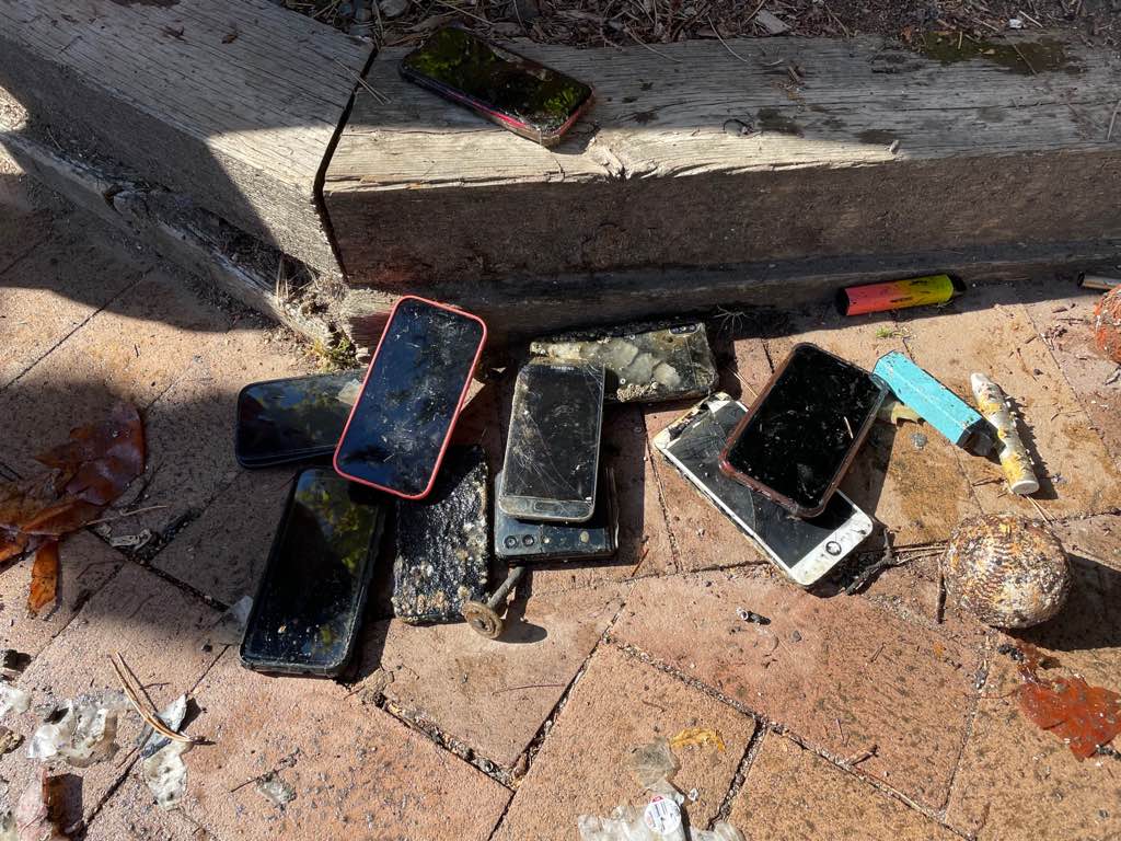
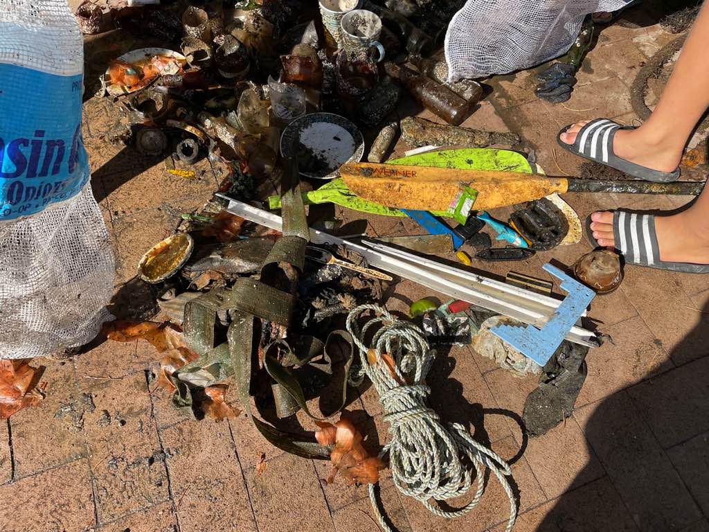
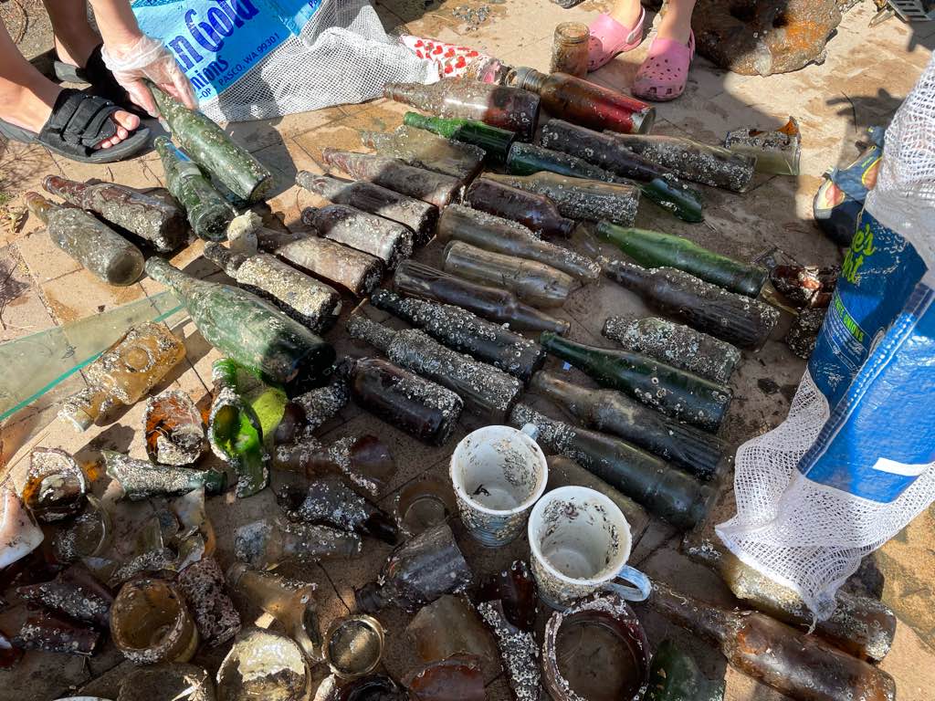
The fact that Peristera is an unihabited island and the small bay that the dive against debris was conducted is a common anchorage spot for many leisure boats, contribute to the accumulation of debris and thrash that has been found and collected. In addition there are permanent restrictions on the area for any kind of diving activities as it it declared an archaelogical site, a fact which makes any Clean Up dive more complicate logistically in terms of licencing and conducting it. For this time we had an archaeologist from the Ephorate of Underwater Antiquities together in the team, a thing that facilitate the permission we got to dive on the site.
an old Typewriter which was delivered for maintenance to the owner of Folk museum in Alonnisos, Kostas Mavrikis.
Calm weather, partly cloudy, weak southern winds. Average Water temp 24C
Skopelos Dive Center PC
Kostas Danis
2
5
2
1
6
1
2
1
7
3
1
88
4
2
50.00
55
25.00
10.00
2
estimated
4
2
500.00
2
3
pieces of plastic
plastic bottles
On
kilograms
I have debris data to report
6
Calm (glassy to rippled) for waves 0 – 0.1 meter high
5
3
2
m2
4
2
meters
seagrass
15
6
2
3
4
1
3
1
4
42
1
3
4
5
3
2
Greece
State\Province
Thessaly
City
Alonnisos
Map Help


Dive Location

If you know your survey site coordinates, enter them manually in decimal degrees using WGS84 Map Datum. Use the minus sign for latitudes south of the equator and longitudes west of the Prime Meridian to 180 degrees.

If you do not know your survey site coordinates, click the “Map Location” tab to use the map to zoom into your survey site and drop the pin on the map to fall within your survey dive site in the water (not on land or the beach). Ensure you zoom in as much as possible to ensure data accuracy.

Entangled Help


Use the vertical tabs below to record any entangled animals you found of each type.

DROC-Los Cabezos

9
65

19.75778, -70.51851

rock
Fiona
Still the same regarding item 95. on the slate.....
Waves from the north and Fiona
2
1
1
1
Electrical tape
Duck tape
Aluminium Food Tray
Tablet blister
Divecenter Merlin
Christian Harder
8
2
1
2
10.38
60
7.00
3.00
measured
2072.00
1
On
kilograms
I have debris data to report
1
Slight for waves 0.5 -1.25 meter high
23
m2
meters
coral reef
24
4
Dominican Republic
State\Province
Puerto Plata
City
Sosua
Map Help


Dive Location

If you know your survey site coordinates, enter them manually in decimal degrees using WGS84 Map Datum. Use the minus sign for latitudes south of the equator and longitudes west of the Prime Meridian to 180 degrees.

If you do not know your survey site coordinates, click the “Map Location” tab to use the map to zoom into your survey site and drop the pin on the map to fall within your survey dive site in the water (not on land or the beach). Ensure you zoom in as much as possible to ensure data accuracy.

Entangled Help


Use the vertical tabs below to record any entangled animals you found of each type.

DROC - The Charamicos Wall

14

19.75565, -70.52336

coral
1
1
Fiona
Waves from the nnorth and Fiona.......
Divecenter Merlin
Christian Harder
3
1
2
4
0.11
60
18.00
8.00
measured
4560.00
On
kilograms
I have debris data to report
Slight for waves 0.5 -1.25 meter high
2
m2
meters
coral reef
Dominican Republic
State\Province
Puerto Plata
City
Sosua
Map Help


Dive Location

If you know your survey site coordinates, enter them manually in decimal degrees using WGS84 Map Datum. Use the minus sign for latitudes south of the equator and longitudes west of the Prime Meridian to 180 degrees.

If you do not know your survey site coordinates, click the “Map Location” tab to use the map to zoom into your survey site and drop the pin on the map to fall within your survey dive site in the water (not on land or the beach). Ensure you zoom in as much as possible to ensure data accuracy.

Entangled Help


Use the vertical tabs below to record any entangled animals you found of each type.

Deep Cove government dock

0
36
0
6

49.3270454246, -122.94686891051

0
0
0
silt
0
0
0
0
0
No
Sunny
1
15
1
3
1
1
Anchour
Sunglasses
Bicycle
Dog leash
Safety pylon
Bike saddle
Divers for Cleaner Lakes and Oceans
Henry Wang
0
0
0
0
0
0
0
0
0
0
0
0
0
6
0
0
0
0
0
7
0
0
0
0
0
0
0
0
0
0
0
0
7
0
0
0
325.00
51
43.00
10.00
18
measured
0
0
44244.50
0
5
0
0
0
Bottles
0
On
pounds
0
I have debris data to report
41
0
0
Calm (glassy to rippled) for waves 0 – 0.1 meter high
0
0
1
0
0
0
0
ft2
0
0
feet
other
37
0
0
0
0
0
0
0
0
23
17
0
0
0
0
0
0
0
0
0
0
0
73
0
0
0
0
0
0
Canada
State\Province
British Columbia
City
North Vancouver
Map Help


Dive Location

If you know your survey site coordinates, enter them manually in decimal degrees using WGS84 Map Datum. Use the minus sign for latitudes south of the equator and longitudes west of the Prime Meridian to 180 degrees.

If you do not know your survey site coordinates, click the “Map Location” tab to use the map to zoom into your survey site and drop the pin on the map to fall within your survey dive site in the water (not on land or the beach). Ensure you zoom in as much as possible to ensure data accuracy.

Entangled Help


Use the vertical tabs below to record any entangled animals you found of each type.

Ecosystem Other
Silt

Portmellon S24787

0
12
0
0
0
0
1
sand
0
1
0
2
0

50.262250661672, -4.7851088044137

East winds blowing it in
Ne winds force 6
Viewpoint diving
David skinner
0
0
0
0
0
0
0
0
0
0
0
0
0
0
0
0
0
0
0
2
0
0
0
0
0
0
0
0
0
0
0
0
0
0
0
0
0.50
45
7.00
2.00
0
estimated
0
0
3245.64
0
0
0
0
0
Plastic food wrappers
0
On
kilograms
0
I have debris data to report
1
1
0
Smooth (wavelets) for waves 0.1 - 0.5 meter high
0
0
0
0
0
0
0
m2
0
0
meters
rocky reef
0
0
0
0
0
0
0
0
0
1
0
0
0
0
0
0
0
0
0
0
0
0
0
0
0
0
0
0
0
United Kingdom
State\Province
Cornwall
City
Portmellon
Map Help


Dive Location

If you know your survey site coordinates, enter them manually in decimal degrees using WGS84 Map Datum. Use the minus sign for latitudes south of the equator and longitudes west of the Prime Meridian to 180 degrees.

If you do not know your survey site coordinates, click the “Map Location” tab to use the map to zoom into your survey site and drop the pin on the map to fall within your survey dive site in the water (not on land or the beach). Ensure you zoom in as much as possible to ensure data accuracy.

Entangled Help


Use the vertical tabs below to record any entangled animals you found of each type.

Abu Dhabi break water #647992

0
0
0
0

24.475974206363, 54.295308739416

0
0
0
sand
0
0
0
0
0
Plastic
Plastic
Calml
Abu Dhabi Diving Centre
Saeed S Majed
0
0
0
0
0
0
0
0
0
0
0
0
0
0
0
0
0
0
0
2
0
0
0
0
0
0
1
0
0
0
0
0
0
0
0
0
1.00
52
7.00
3.00
0
estimated
0
0
1500.00
0
0
0
0
0
0
On
kilograms
0
I have debris data to report
0
0
0
Smooth (wavelets) for waves 0.1 - 0.5 meter high
0
0
0
0
0
0
0
m2
0
0
meters
rocky reef
0
0
0
0
0
0
0
0
0
0
0
0
0
0
0
0
0
0
0
0
0
0
0
0
0
0
0
0
0
United Arab Emirates
State\Province
Abu Dhabi
City
Abu Dhabi
Map Help


Dive Location

If you know your survey site coordinates, enter them manually in decimal degrees using WGS84 Map Datum. Use the minus sign for latitudes south of the equator and longitudes west of the Prime Meridian to 180 degrees.

If you do not know your survey site coordinates, click the “Map Location” tab to use the map to zoom into your survey site and drop the pin on the map to fall within your survey dive site in the water (not on land or the beach). Ensure you zoom in as much as possible to ensure data accuracy.

Entangled Help


Use the vertical tabs below to record any entangled animals you found of each type.

Edmonds Underwater Park #444074

0
0
0
0

47.81435, -122.381549

0
0
0
sand
0
0
0
0
0
Weird car thing
Calm
Tro Ota
0
0
0
0
0
0
0
0
0
0
0
0
0
0
0
0
0
0
0
2
0
0
0
0
0
0
0
0
0
0
0
0
0
0
0
0
5.70
47
33.00
30.00
0
measured
0
0
0
0
453.43
0
0
0
0
0
Metal fragments
Glass
Plastic sheet
0
On
pounds
0
I have debris data to report
0
0
0
Calm (glassy to rippled) for waves 0 – 0.1 meter high
1
0
0
0
0
0
0
ft2
0
0
feet
rocky reef
0
0
4
0
0
0
1
0
0
0
0
0
0
0
0
1
0
0
0
0
0
0
0
1
0
0
0
0
0
United States
State\Province
Washington
City
Edmonds
Map Help


Dive Location

If you know your survey site coordinates, enter them manually in decimal degrees using WGS84 Map Datum. Use the minus sign for latitudes south of the equator and longitudes west of the Prime Meridian to 180 degrees.

If you do not know your survey site coordinates, click the “Map Location” tab to use the map to zoom into your survey site and drop the pin on the map to fall within your survey dive site in the water (not on land or the beach). Ensure you zoom in as much as possible to ensure data accuracy.

Entangled Help


Use the vertical tabs below to record any entangled animals you found of each type.

Shark Fin

0
0
0
0

20.737553, -156.968634

0
0
0
coral
0
0
0
1
0
People suck
Snorkel
Calm and sunny
Dive Maui
Renee Street
0
0
0
0
0
0
0
0
1
0
0
0
0
0
0
0
0
0
0
3
0
0
0
0
0
0
0
0
0
0
0
0
0
0
0
0
3.50
54
67.00
25.00
0
estimated
0
0
0
3
15853.60
0
0
0
0
0
0
On
pounds
0
I have debris data to report
0
0
0
Smooth (wavelets) for waves 0.1 - 0.5 meter high
0
0
0
0
0
0
0
ft2
0
0
feet
coral reef
0
0
0
0
0
0
0
0
0
0
0
0
0
0
0
0
0
1
0
0
0
0
0
0
0
0
0
0
0
United States
State\Province
HI
City
Lanai City
Map Help


Dive Location

If you know your survey site coordinates, enter them manually in decimal degrees using WGS84 Map Datum. Use the minus sign for latitudes south of the equator and longitudes west of the Prime Meridian to 180 degrees.

If you do not know your survey site coordinates, click the “Map Location” tab to use the map to zoom into your survey site and drop the pin on the map to fall within your survey dive site in the water (not on land or the beach). Ensure you zoom in as much as possible to ensure data accuracy.

Entangled Help


Use the vertical tabs below to record any entangled animals you found of each type.

Marsa Bareika

0
0
5
0

27.781054, 34.20955

0
0
0
sand
0
12
0
0
0
Good
Elite Diving
Valeria
0
0
0
11
0
0
0
0
0
0
0
0
0
0
0
0
0
0
0
2
0
0
0
0
0
0
0
5
0
0
0
0
0
0
0
0
0.80
50
12.00
6.00
0
estimated
0
0
0
0
17585.50
0
0
0
0
0
2
On
kilograms
0
I have debris data to report
0
0
0
Calm (glassy to rippled) for waves 0 – 0.1 meter high
0
0
1
0
0
0
0
m2
0
0
meters
coral reef
0
0
0
0
0
0
0
0
0
0
0
0
0
0
0
0
0
0
0
0
0
0
0
0
0
0
0
0
0
Egypt
Map Help


Dive Location

If you know your survey site coordinates, enter them manually in decimal degrees using WGS84 Map Datum. Use the minus sign for latitudes south of the equator and longitudes west of the Prime Meridian to 180 degrees.

If you do not know your survey site coordinates, click the “Map Location” tab to use the map to zoom into your survey site and drop the pin on the map to fall within your survey dive site in the water (not on land or the beach). Ensure you zoom in as much as possible to ensure data accuracy.

Entangled Help


Use the vertical tabs below to record any entangled animals you found of each type.

DROC - Matthew's Reef

7

19.3659508, -68.8488826

coral
two propellers
Fiona hurrican
Coral Point Diving
Edmund Settle
2
10.00
50
13.00
10.00
estimated
100.00
On
kilograms
I have debris data to report
Smooth (wavelets) for waves 0.1 - 0.5 meter high
4
m2
meters
coral reef
2
1
Dominican Republic
State\Province
La Altagracia
City
Bayahibe (La Romana)
Map Help


Dive Location

If you know your survey site coordinates, enter them manually in decimal degrees using WGS84 Map Datum. Use the minus sign for latitudes south of the equator and longitudes west of the Prime Meridian to 180 degrees.

If you do not know your survey site coordinates, click the “Map Location” tab to use the map to zoom into your survey site and drop the pin on the map to fall within your survey dive site in the water (not on land or the beach). Ensure you zoom in as much as possible to ensure data accuracy.

Entangled Help


Use the vertical tabs below to record any entangled animals you found of each type.

Subscribe to