Menu

Kai Iwi Lakes

25
sand

-35.808909053113, 173.65915725717

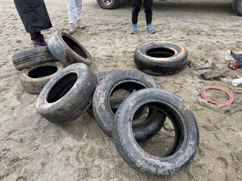
Dive 1 we tried to lift a huge tyre, have to go back 4X lift bags could not get it free from the silt/sand
Perfect day, +- 5Kph wind form the West
1
3
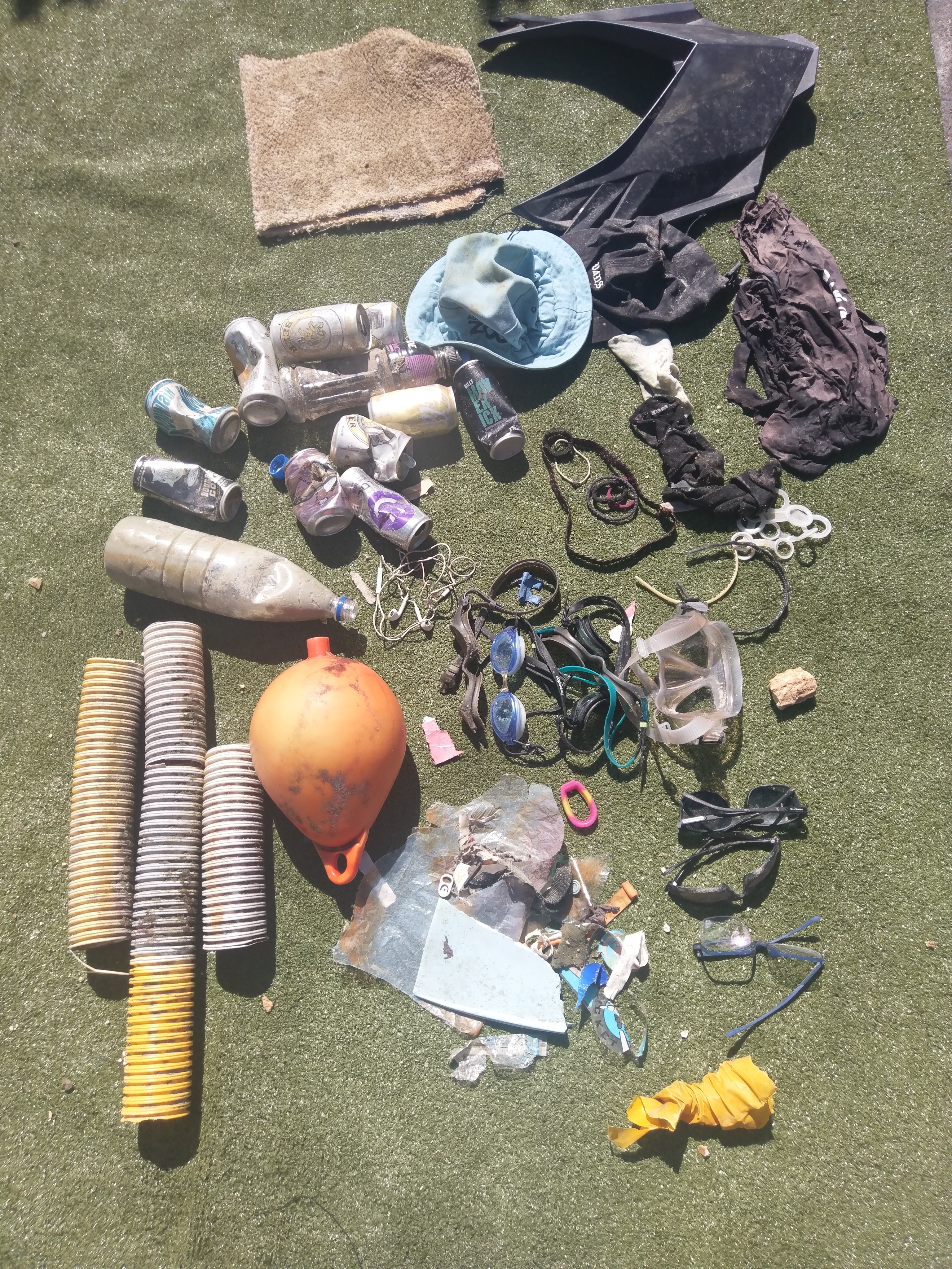
Jetski plastic cover
glasses
Martin Ruddy
3
14
8
1
2
2
2
1
5.00
51
16.00
13.00
estimated
1500.00
2
On
kilograms
I have debris data to report
Smooth (wavelets) for waves 0.1 - 0.5 meter high m2
meters
other
3
9
New Zealand
Map Help


Dive Location

If you know your survey site coordinates, enter them manually in decimal degrees using WGS84 Map Datum. Use the minus sign for latitudes south of the equator and longitudes west of the Prime Meridian to 180 degrees.

If you do not know your survey site coordinates, click the “Map Location” tab to use the map to zoom into your survey site and drop the pin on the map to fall within your survey dive site in the water (not on land or the beach). Ensure you zoom in as much as possible to ensure data accuracy.

Entangled Help


Use the vertical tabs below to record any entangled animals you found of each type.

Ecosystem Other
Fresh water lake

ADS305 - House Reef

1
6
rock

28.1421475674, -16.439441525769

No
Snack tray
Calm
Tenerife Diving Academy
Kim Timmers
1
1
3
3
4
0.20
35
12.00
2.00
estimated
200.00
Plastic
Cigarette ends
Cans
On
kilograms
I have debris data to report
Calm (glassy to rippled) for waves 0 – 0.1 meter high m2
meters
rocky reef
2
Spain
State\Province
Santa Cruz de Tenerife
City
Abades, Arico
Map Help


Dive Location

If you know your survey site coordinates, enter them manually in decimal degrees using WGS84 Map Datum. Use the minus sign for latitudes south of the equator and longitudes west of the Prime Meridian to 180 degrees.

If you do not know your survey site coordinates, click the “Map Location” tab to use the map to zoom into your survey site and drop the pin on the map to fall within your survey dive site in the water (not on land or the beach). Ensure you zoom in as much as possible to ensure data accuracy.

Entangled Help


Use the vertical tabs below to record any entangled animals you found of each type.

Mae Haad Reef North

89
369
2
sand
14

10.08600063733, 99.824556535201

2 snorkelers assisted the clean up
Airbed
calm and sunny
1
Airbed
Black Turtle Dive
Dorothy Lee
16
3
30
3
9
7
5
1
4
2
191
17
3
103.00
65
4.00
1.00
measured
300.00
1
Plastic
On
kilograms
I have debris data to report
24
Calm (glassy to rippled) for waves 0 – 0.1 meter high
1
1
Plastic wrappers
Crabs
Released Unharmed
15
2
12
33
m2
1
meters
coral reef
11
7
1
5
23
5
19
5
70
Thailand
State\Province
Surat Thani
City
Koh Tao
Map Help


Dive Location

If you know your survey site coordinates, enter them manually in decimal degrees using WGS84 Map Datum. Use the minus sign for latitudes south of the equator and longitudes west of the Prime Meridian to 180 degrees.

If you do not know your survey site coordinates, click the “Map Location” tab to use the map to zoom into your survey site and drop the pin on the map to fall within your survey dive site in the water (not on land or the beach). Ensure you zoom in as much as possible to ensure data accuracy.

Entangled Help


Use the vertical tabs below to record any entangled animals you found of each type.

ADS305 - House Reef

150
rock
3

28.14197167987, -16.439748273511

No
Tire
Windy
Tenerife Diving Academy
Kim Timmers
4
2
5
2
5.00
45
5.00
1.00
estimated
1
400.00
1
3
Plastic
Metal
Cloth
On
kilograms
I have debris data to report
Calm (glassy to rippled) for waves 0 – 0.1 meter high
1
30
m2
meters
rocky reef
5
1
7
19
Spain
State\Province
Santa Cruz de Tenerife
City
Abades, Arico
Map Help


Dive Location

If you know your survey site coordinates, enter them manually in decimal degrees using WGS84 Map Datum. Use the minus sign for latitudes south of the equator and longitudes west of the Prime Meridian to 180 degrees.

If you do not know your survey site coordinates, click the “Map Location” tab to use the map to zoom into your survey site and drop the pin on the map to fall within your survey dive site in the water (not on land or the beach). Ensure you zoom in as much as possible to ensure data accuracy.

Entangled Help


Use the vertical tabs below to record any entangled animals you found of each type.

Albert Dyck Lake

4
7
0

49.026068557057, -122.34528153484

0
0
0
silt
0
3
3
0
0
No
Mixed
1
1
1
1
0
0
0
0
0
0
0
0
0
0
0
0
0
0
0
0
Vape
Sunglasses
Skateboard
Boat paddle
Divers for Cleaner Lakes and Oceans
Henry Wang
0
0
0
4
0
0
0
0
1
0
0
0
0
0
0
0
0
0
0
4
0
0
2
0
0
0
0
2
0
0
4
0
0
0
262.90
54
54.00
3.00
1
measured
0
0
11982.00
0
8
1
0
0
Bee cans
0
On
pounds
0
I have debris data to report
6
0
0
Calm (glassy to rippled) for waves 0 – 0.1 meter high
0
0
0
0
0
0
0
ft2
0
1
feet
other
2
0
0
0
0
0
0
0
0
2
0
0
0
0
0
0
58
0
0
0
0
0
0
0
0
0
0
0
Canada
State\Province
British Columbia
City
Abbotsford
Map Help


Dive Location

If you know your survey site coordinates, enter them manually in decimal degrees using WGS84 Map Datum. Use the minus sign for latitudes south of the equator and longitudes west of the Prime Meridian to 180 degrees.

If you do not know your survey site coordinates, click the “Map Location” tab to use the map to zoom into your survey site and drop the pin on the map to fall within your survey dive site in the water (not on land or the beach). Ensure you zoom in as much as possible to ensure data accuracy.

Entangled Help


Use the vertical tabs below to record any entangled animals you found of each type.

Sosua Beach

28
81

19.760916666667, -70.518583333333

sand
6
Rain and waves
Brooom
Mostly sunny
Some waves from north
5
4
1
Fiberglas parts
Sponge
Brooom
Divecenter Merlin
Claudio Brandileone
1
26
13
2
4
58
1
29.00
56
7.00
1.50
estimated
10000.00
6
Plastic bottles
cans alu
7
On
pounds
I have debris data to report
Smooth (wavelets) for waves 0.1 - 0.5 meter high
2
sponge
Released Unharmed
Soldier fish
crab
Released Unharmed
2
2
bottle
43
m2
4
meters
other
47
21
1
2
34
1
Dominican Republic
State\Province
Puerto Plata
City
Sosua
Map Help


Dive Location

If you know your survey site coordinates, enter them manually in decimal degrees using WGS84 Map Datum. Use the minus sign for latitudes south of the equator and longitudes west of the Prime Meridian to 180 degrees.

If you do not know your survey site coordinates, click the “Map Location” tab to use the map to zoom into your survey site and drop the pin on the map to fall within your survey dive site in the water (not on land or the beach). Ensure you zoom in as much as possible to ensure data accuracy.

Entangled Help


Use the vertical tabs below to record any entangled animals you found of each type.

Ecosystem Other
SAND

Edmonds Underwater Park

0
24
0
0

47.815363, -122.381055

0
0
0
sand
0
0
0
1
1
Went out to the boundary with the intent to gather bottles but were still surprised by how many are left
Boaters tying up to our buoys and throwing bottles overboard
Fun clean up today!
Brass fitting of some sort
Windy and rainy
Tro Ota
0
4
0
0
0
0
0
0
0
0
0
0
0
0
0
0
0
0
0
3
0
0
0
0
0
0
0
0
0
0
0
0
0
0
0
0
70.00
35
42.00
35.00
0
estimated
0
0
0
1
4597.94
0
0
0
2
0
Broken glass beer bottles
Screws
Fishing line
0
On
pounds
0
I have debris data to report
20
0
0
Slight for waves 0.5 -1.25 meter high
2
0
0
0
0
0
0
ft2
0
0
feet
rocky reef
34
0
0
0
0
0
2
0
1
0
0
0
0
0
0
1
0
0
0
0
0
0
40
0
0
0
0
0
0
United States
State\Province
WA
City
Edmonds
Map Help


Dive Location

If you know your survey site coordinates, enter them manually in decimal degrees using WGS84 Map Datum. Use the minus sign for latitudes south of the equator and longitudes west of the Prime Meridian to 180 degrees.

If you do not know your survey site coordinates, click the “Map Location” tab to use the map to zoom into your survey site and drop the pin on the map to fall within your survey dive site in the water (not on land or the beach). Ensure you zoom in as much as possible to ensure data accuracy.

Entangled Help


Use the vertical tabs below to record any entangled animals you found of each type.

Churchill Barrier 1

0
0
0
0

58.89513, -2.897541

0
0
0
sand
0
0
0
7
0
Windy
Kraken Diving
Rob Slight
0
0
0
0
0
0
0
0
0
0
0
0
0
0
0
0
0
0
0
4
0
0
0
0
0
0
0
0
0
0
0
0
0
0
0
0
0.90
30
7.00
3.00
1
measured
0
0
0
0
448.91
0
0
0
0
0
0
On
kilograms
0
I have debris data to report
0
0
0
Smooth (wavelets) for waves 0.1 - 0.5 meter high
1
0
0
0
0
0
0
m2
0
0
meters
rocky reef
0
0
0
0
0
0
0
0
0
0
0
0
0
0
0
0
0
0
0
0
0
0
0
0
0
0
0
0
0
United Kingdom
State\Province
Orkney
City
St Marys
Map Help


Dive Location

If you know your survey site coordinates, enter them manually in decimal degrees using WGS84 Map Datum. Use the minus sign for latitudes south of the equator and longitudes west of the Prime Meridian to 180 degrees.

If you do not know your survey site coordinates, click the “Map Location” tab to use the map to zoom into your survey site and drop the pin on the map to fall within your survey dive site in the water (not on land or the beach). Ensure you zoom in as much as possible to ensure data accuracy.

Entangled Help


Use the vertical tabs below to record any entangled animals you found of each type.

Churchill Barrier 1

1
0
0
0

58.894994, -2.897456

0
0
0
sand
0
3
0
0
0
Windy and wet
Kraken Diving
Rob Slight
0
0
0
0
0
0
0
0
0
0
0
0
0
2
0
0
1
0
0
4
0
0
0
0
0
0
0
0
0
0
0
0
0
0
0
0
2.50
30
6.00
2.00
1
estimated
0
0
0
0
354.56
0
0
0
0
0
0
On
kilograms
0
I have debris data to report
0
0
0
Smooth (wavelets) for waves 0.1 - 0.5 meter high
0
0
0
0
0
0
0
m2
0
0
meters
rocky reef
0
0
0
0
0
0
0
0
0
0
0
0
0
0
0
0
0
0
0
0
0
0
2
0
0
0
0
0
0
United Kingdom
State\Province
Orkney
City
St Marys
Map Help


Dive Location

If you know your survey site coordinates, enter them manually in decimal degrees using WGS84 Map Datum. Use the minus sign for latitudes south of the equator and longitudes west of the Prime Meridian to 180 degrees.

If you do not know your survey site coordinates, click the “Map Location” tab to use the map to zoom into your survey site and drop the pin on the map to fall within your survey dive site in the water (not on land or the beach). Ensure you zoom in as much as possible to ensure data accuracy.

Entangled Help


Use the vertical tabs below to record any entangled animals you found of each type.

ADS598 - Caldè Fornaci

1
10
0

45.948238682946, 8.6609318345404

0
0
0
silt
0
0
0
2
0
Grill party
Filtro olio
Cloudy
1
1
0
0
0
0
0
0
0
0
0
0
0
0
0
0
0
0
0
0
Oil Filter
Clock
Acqua Club Varese
Jessica Cipolla
1
0
0
0
0
0
0
0
0
0
0
0
0
0
0
0
0
0
0
7
0
0
0
0
0
1
0
0
0
0
0
0
3
0
8.00
40
20.00
5.00
0
measured
0
0
1500.00
0
0
0
2
0
Glass
Plastic
3
On
kilograms
0
I have debris data to report
4
0
0
Calm (glassy to rippled) for waves 0 – 0.1 meter high
0
0
0
0
7
0
0
m2
0
0
meters
other
1
0
0
0
1
5
0
3
0
0
0
0
0
0
5
0
0
0
0
0
0
9
0
0
0
0
1
0
Italy
State\Province
Va
City
Varese
Map Help


Dive Location

If you know your survey site coordinates, enter them manually in decimal degrees using WGS84 Map Datum. Use the minus sign for latitudes south of the equator and longitudes west of the Prime Meridian to 180 degrees.

If you do not know your survey site coordinates, click the “Map Location” tab to use the map to zoom into your survey site and drop the pin on the map to fall within your survey dive site in the water (not on land or the beach). Ensure you zoom in as much as possible to ensure data accuracy.

Entangled Help


Use the vertical tabs below to record any entangled animals you found of each type.

Ecosystem Other
lake
Subscribe to