This survey was completed in tandem with the 40th Annual Avalon Underwater Harbour Cleanup event, with the help of our partners at Seiko!
The tradition started in the 1970s in a community effort to clean the harbor, and this year, USC's Catalina Hyperbaric Chamber and Wrigley Institute for Environmental Studies–Catalina Conservation Divers are proud to our part in protecting the health of one of Catalina's coastal treasures by hosting the 40th Annual Avalon Harbor Underwater Cleanup.
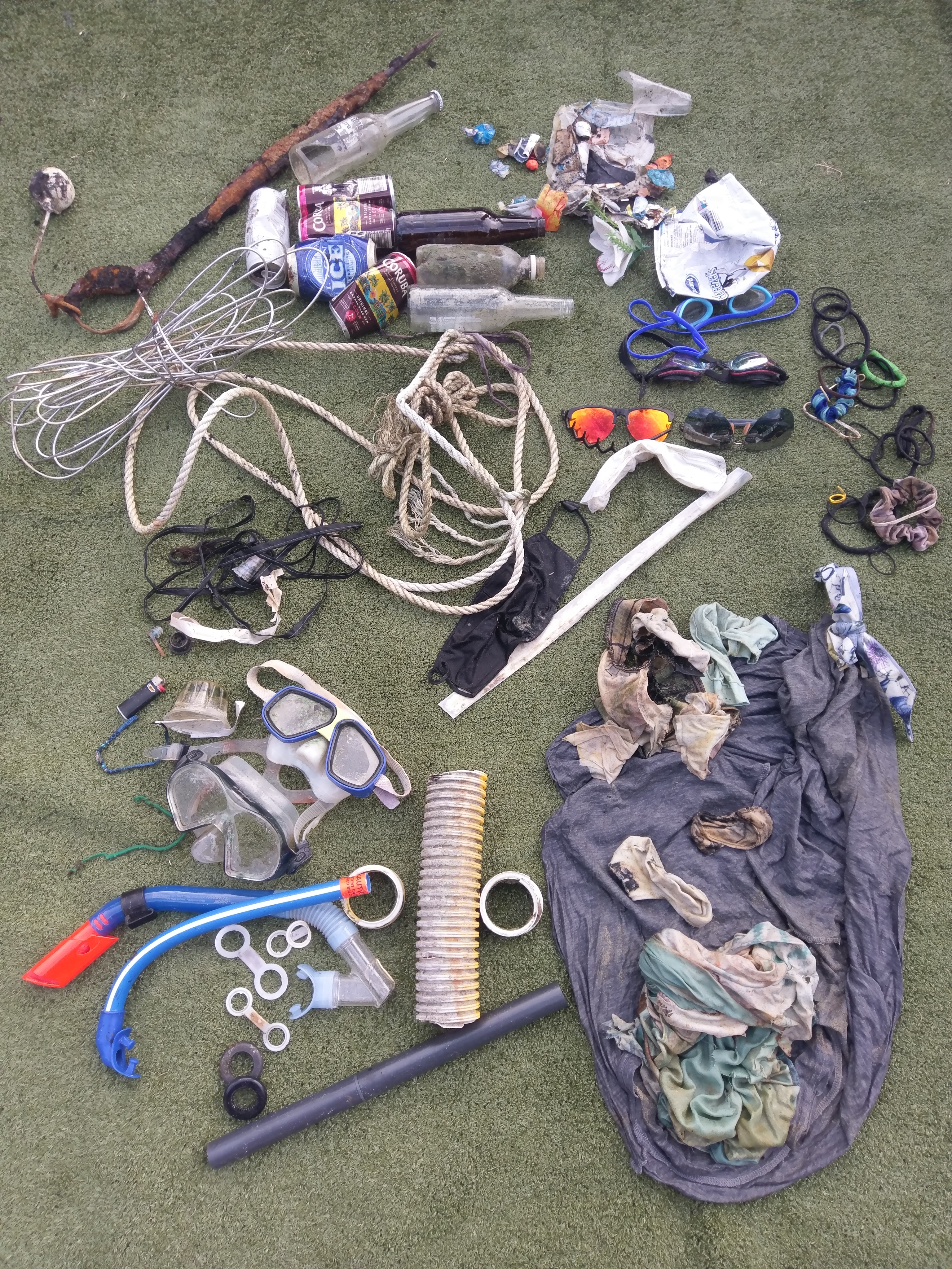
This dive site was next to Green Pier. Most of the debris is commonly found near fishing sites and frequent human activity.
All crabs were sorted and released unharmed!
The most unusual item was the helm of a small boating craft!
These animals were found inside of plastic debris and removed safely back to the ocean.
The octopus was inside a bottle and released safely.
Calm
1
3
54
Achor
Boat Pieces/motor Prop/Helm
Sunglasses
PADI AWARE/Wrigley Institute
Jack Fishman
1
3
44
7
14
211
2
32
6
65
2
2
1126.00
90
18.00
2.00
estimated
130
29541.10
2
21
Fishing gear
Glass Bottles
Plastic Fragments
On
pounds
I have debris data to report
111
Calm (glassy to rippled) for waves 0 – 0.1 meter high
14
2
Fishing Gear/Plastic Debris
Crabs
Released Unharmed
11
51
ft2
15
22
11
Fishing Gear/plastic
Brittle Stars + 1 Octopus
Released Unharmed
feet
other
79
22
11
20
15
1
50
111
130
3
3
United States
State\Province
California
City
Avalon
Map Help
Dive Location
If you know your survey site coordinates, enter them manually in decimal degrees using WGS84 Map Datum. Use the minus sign for latitudes south of the equator and longitudes west of the Prime Meridian to 180 degrees.
If you do not know your survey site coordinates, click the “Map Location” tab to use the map to zoom into your survey site and drop the pin on the map to fall within your survey dive site in the water (not on land or the beach). Ensure you zoom in as much as possible to ensure data accuracy.
Entangled Help
Use the vertical tabs below to record any entangled animals you found of each type.
Calm (glassy to rippled) for waves 0 – 0.1 meter high
11
m2
meters
coral reef
27
2
1
Language
English
Indonesia
State\Province
Bali
City
Klungkung
Map Help
Dive Location
If you know your survey site coordinates, enter them manually in decimal degrees using WGS84 Map Datum. Use the minus sign for latitudes south of the equator and longitudes west of the Prime Meridian to 180 degrees.
If you do not know your survey site coordinates, click the “Map Location” tab to use the map to zoom into your survey site and drop the pin on the map to fall within your survey dive site in the water (not on land or the beach). Ensure you zoom in as much as possible to ensure data accuracy.
Entangled Help
Use the vertical tabs below to record any entangled animals you found of each type.
Current kicked up so badly during the dive we had to abort trying to lift and will return to gather more debris later (many more bottles for sure)
Ferry debris
Screwdriver handle
Trapped inside the glove
Rainy
Tro Ota
0
0
0
0
0
0
0
0
0
0
0
0
0
0
0
0
0
0
0
2
0
0
0
0
0
0
0
0
0
0
0
0
0
0
0
0
3.00
35
34.00
25.00
0
estimated
0
0
0
0
695.90
0
0
0
0
0
Glove
Broken bottle piece
Wire
0
On
pounds
0
I have debris data to report
0
0
0
Smooth (wavelets) for waves 0.1 - 0.5 meter high
0
0
0
Released Unharmed
Gunnel
1
Glove
0
0
0
0
ft2
1
0
feet
rocky reef
1
0
0
0
0
0
0
0
0
0
0
0
0
0
0
1
0
0
0
0
0
0
1
0
0
0
0
0
0
Language
English
United States
State\Province
WA
City
Edmonds
Map Help
Dive Location
If you know your survey site coordinates, enter them manually in decimal degrees using WGS84 Map Datum. Use the minus sign for latitudes south of the equator and longitudes west of the Prime Meridian to 180 degrees.
If you do not know your survey site coordinates, click the “Map Location” tab to use the map to zoom into your survey site and drop the pin on the map to fall within your survey dive site in the water (not on land or the beach). Ensure you zoom in as much as possible to ensure data accuracy.
Entangled Help
Use the vertical tabs below to record any entangled animals you found of each type.
Previous adverse weather from couple of months prior
satellite dish!
Calm
1
3
1
1
1
1
5
1
Spectacles
PPE Mask
Umbrella
Shower Hose
Kettle
Satellite Dish
CD's
Pens
Black Turtle Dive
Dan Summerfield
33
10
45
6
8
3
1
10
11
62
6
257.00
45
3.00
1.00
9
measured
300.00
Plastic Fragments
Plastic Bags
On
kilograms
I have debris data to report
83
Calm (glassy to rippled) for waves 0 – 0.1 meter high
2
7
5
14
48
m2
3
meters
coral reef
73
4
3
11
22
19
4
29
58
486
Language
English
Thailand
State\Province
Surat Thani
City
Koh Tao
Map Help
Dive Location
If you know your survey site coordinates, enter them manually in decimal degrees using WGS84 Map Datum. Use the minus sign for latitudes south of the equator and longitudes west of the Prime Meridian to 180 degrees.
If you do not know your survey site coordinates, click the “Map Location” tab to use the map to zoom into your survey site and drop the pin on the map to fall within your survey dive site in the water (not on land or the beach). Ensure you zoom in as much as possible to ensure data accuracy.
Entangled Help
Use the vertical tabs below to record any entangled animals you found of each type.
More to go and collect, found a large tire. Will take lift bags next time
Calm day
24
Hair Ties
Private
Martin Ruddy
1
1
8
2
1
1
4.00
60
13.00
5.00
1
estimated
6300.00
3
Hair ties (bands)
2
On
kilograms
I have debris data to report
3
Calm (glassy to rippled) for waves 0 – 0.1 meter high
1
2
m2
1
3
meters
other
1
1
1
5
Language
English
New Zealand
State\Province
North Island
City
Auckland
Map Help
Dive Location
If you know your survey site coordinates, enter them manually in decimal degrees using WGS84 Map Datum. Use the minus sign for latitudes south of the equator and longitudes west of the Prime Meridian to 180 degrees.
If you do not know your survey site coordinates, click the “Map Location” tab to use the map to zoom into your survey site and drop the pin on the map to fall within your survey dive site in the water (not on land or the beach). Ensure you zoom in as much as possible to ensure data accuracy.
Entangled Help
Use the vertical tabs below to record any entangled animals you found of each type.