Cleanup was done in conjunction with the SXM Coastal Cleanup Project, sponsored by R4CR and World Bank funding, in conjunction with The Scuba Shop. Boat and surface support was provided by SXM Divers, Ocean Explorers, and Aqua Mania Dive Adventures.
N/A
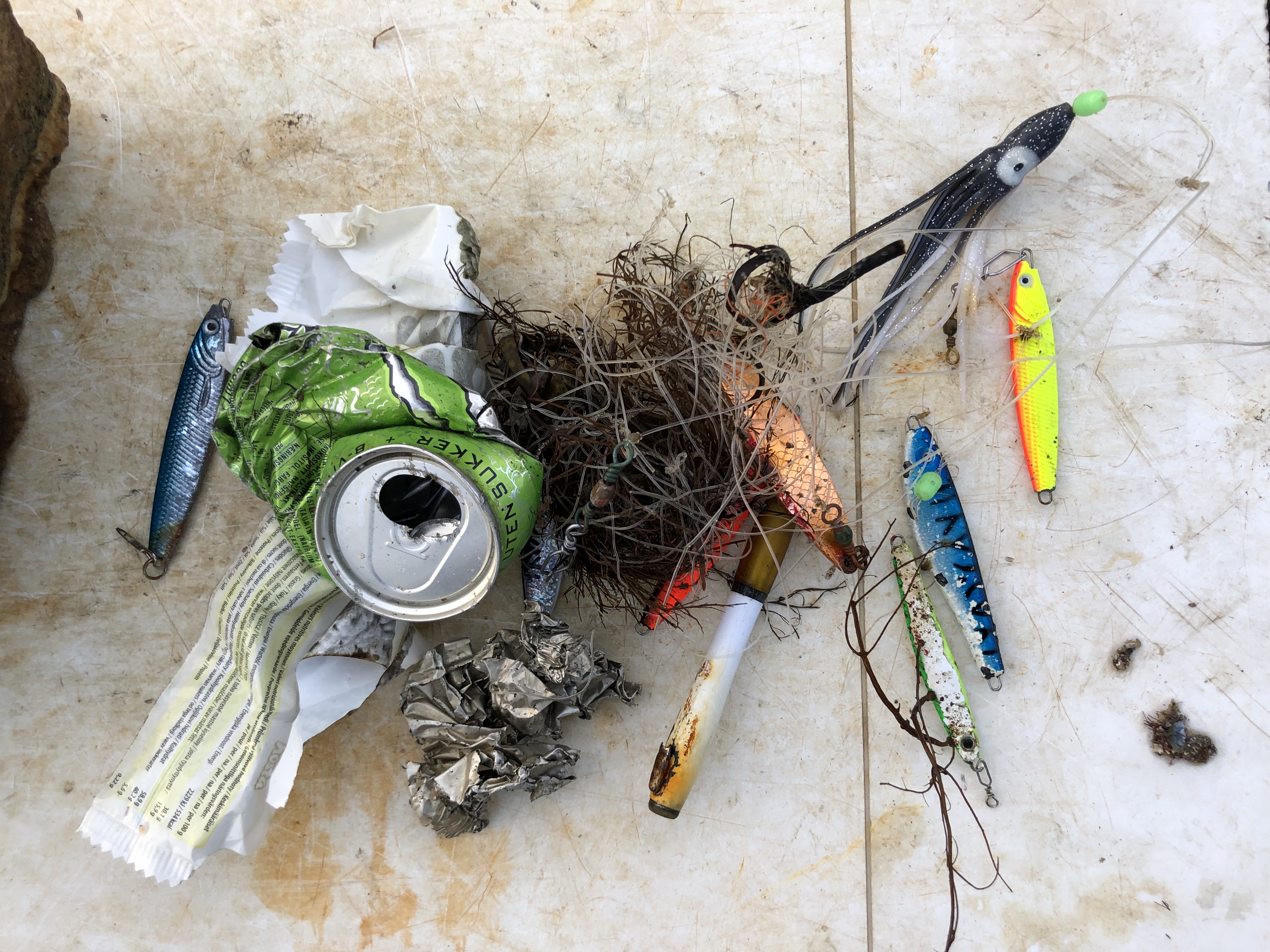
Beach Umbrella, whole, in working condition
Generally calm, high temperatures avg. 85°F, low temperatures avg. 77°F. Daily light showers.
Ryan Downey
10
50
1
4
1
15
19
4
1
2
1
527.00
96
18.00
4.00
7
measured
160000.00
5
Plastic cups
Plastic bags
Zinc roofing sheets
On
pounds
I have debris data to report
6
Calm (glassy to rippled) for waves 0 – 0.1 meter high
9
0
0
0
0
0
25
ft2
0
feet
seagrass
0
250
5
7
75
Netherlands Antilles
Map Help
Dive Location
If you know your survey site coordinates, enter them manually in decimal degrees using WGS84 Map Datum. Use the minus sign for latitudes south of the equator and longitudes west of the Prime Meridian to 180 degrees.
If you do not know your survey site coordinates, click the “Map Location” tab to use the map to zoom into your survey site and drop the pin on the map to fall within your survey dive site in the water (not on land or the beach). Ensure you zoom in as much as possible to ensure data accuracy.
Entangled Help
Use the vertical tabs below to record any entangled animals you found of each type.
Calm (glassy to rippled) for waves 0 – 0.1 meter high
2
3
m2
5
1
meters
coral reef
2
1
1
Language
English
Indonesia
City
Nusa Penida, Bali
Map Help
Dive Location
If you know your survey site coordinates, enter them manually in decimal degrees using WGS84 Map Datum. Use the minus sign for latitudes south of the equator and longitudes west of the Prime Meridian to 180 degrees.
If you do not know your survey site coordinates, click the “Map Location” tab to use the map to zoom into your survey site and drop the pin on the map to fall within your survey dive site in the water (not on land or the beach). Ensure you zoom in as much as possible to ensure data accuracy.
Entangled Help
Use the vertical tabs below to record any entangled animals you found of each type.
Smooth (wavelets) for waves 0.1 - 0.5 meter high
m2
meters
coral reef
3
1
Language
English
Netherlands Antilles
City
Kralendijk
Map Help
Dive Location
If you know your survey site coordinates, enter them manually in decimal degrees using WGS84 Map Datum. Use the minus sign for latitudes south of the equator and longitudes west of the Prime Meridian to 180 degrees.
If you do not know your survey site coordinates, click the “Map Location” tab to use the map to zoom into your survey site and drop the pin on the map to fall within your survey dive site in the water (not on land or the beach). Ensure you zoom in as much as possible to ensure data accuracy.
Entangled Help
Use the vertical tabs below to record any entangled animals you found of each type.
Smooth (wavelets) for waves 0.1 - 0.5 meter high
m2
meters
kelp
1
Language
English
Norway
City
Saltstraumen
Map Help
Dive Location
If you know your survey site coordinates, enter them manually in decimal degrees using WGS84 Map Datum. Use the minus sign for latitudes south of the equator and longitudes west of the Prime Meridian to 180 degrees.
If you do not know your survey site coordinates, click the “Map Location” tab to use the map to zoom into your survey site and drop the pin on the map to fall within your survey dive site in the water (not on land or the beach). Ensure you zoom in as much as possible to ensure data accuracy.
Entangled Help
Use the vertical tabs below to record any entangled animals you found of each type.
Smooth (wavelets) for waves 0.1 - 0.5 meter high
m2
meters
kelp
Language
English
Norway
City
Saltstraumen
Map Help
Dive Location
If you know your survey site coordinates, enter them manually in decimal degrees using WGS84 Map Datum. Use the minus sign for latitudes south of the equator and longitudes west of the Prime Meridian to 180 degrees.
If you do not know your survey site coordinates, click the “Map Location” tab to use the map to zoom into your survey site and drop the pin on the map to fall within your survey dive site in the water (not on land or the beach). Ensure you zoom in as much as possible to ensure data accuracy.
Entangled Help
Use the vertical tabs below to record any entangled animals you found of each type.
My adopted dive site can I get a new certificate in my name please?
Hair tie
Mild wind and waves
0
0
0
0
0
0
0
0
0
0
0
0
0
0
0
0
0
0
0
0
Erika Sullivan
Erika Sullivan
0
0
0
0
0
0
0
0
0
0
0
0
0
0
0
0
0
0
0
2
0
0
0
0
0
0
0
0
0
0
0
0
0
0
0.00
56
10.00
5.00
0
estimated
0
0
656.16
0
0
0
0
0
Lack of rubbish removal
Irresponsible fisherman
Irresponsible day visitors
0
On
kilograms
0
I have debris data to report
0
0
0
Calm (glassy to rippled) for waves 0 – 0.1 meter high
0
0
0
0
0
0
0
m2
0
0
meters
seagrass
0
0
0
0
0
0
0
0
0
0
0
0
0
0
0
1
0
0
0
0
0
0
0
0
0
0
0
0
Language
English
Australia
State\Province
South Australia
City
Rapid Bay
Map Help
Dive Location
If you know your survey site coordinates, enter them manually in decimal degrees using WGS84 Map Datum. Use the minus sign for latitudes south of the equator and longitudes west of the Prime Meridian to 180 degrees.
If you do not know your survey site coordinates, click the “Map Location” tab to use the map to zoom into your survey site and drop the pin on the map to fall within your survey dive site in the water (not on land or the beach). Ensure you zoom in as much as possible to ensure data accuracy.
Entangled Help
Use the vertical tabs below to record any entangled animals you found of each type.
The site was surprisingly clean today, we think local divers have been tidying up - hurrah!
Knife
Windy but not raining.
1
1
knife
chewing gum
Adelaide Scuba
Jen Will
2
0.25
29
7.00
4.00
measured
1
1000.00
fishing hooks
1
On
kilograms
I have debris data to report
1
Smooth (wavelets) for waves 0.1 - 0.5 meter high
m2
meters
other
Language
English
Australia
State\Province
South Australia
City
Adelaide
Map Help
Dive Location
If you know your survey site coordinates, enter them manually in decimal degrees using WGS84 Map Datum. Use the minus sign for latitudes south of the equator and longitudes west of the Prime Meridian to 180 degrees.
If you do not know your survey site coordinates, click the “Map Location” tab to use the map to zoom into your survey site and drop the pin on the map to fall within your survey dive site in the water (not on land or the beach). Ensure you zoom in as much as possible to ensure data accuracy.
Entangled Help
Use the vertical tabs below to record any entangled animals you found of each type.