Menu

Sharp Island

4

22.3573726, 114.2943703

0
sand
0
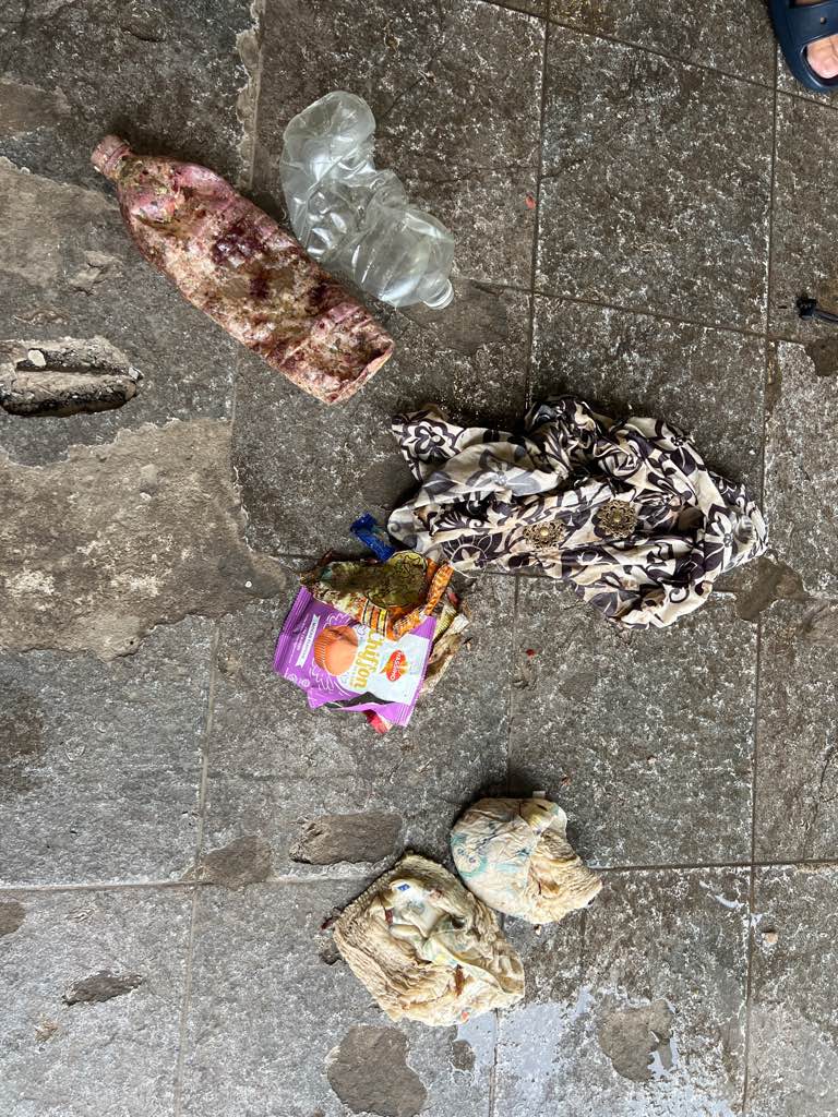
Not too much rubbish was found in the dive site as Sharp Island is the most common dive site in HK diving training. Little rubbish will be clean up every dive by diving instructor and stusents.

However, sometimes fisherman will be there putting the net to catch fishes that can explain why there is fishing net in the site.
Moji Dive HK
Matthew Tung
2
5
2
0
4
5.00
46
8.00
3.00
estimated
0
300.00
On
kilograms
I have debris data to report
Calm (glassy to rippled) for waves 0 – 0.1 meter high m2
3
meters
coral reef
0
3
Hong Kong S.A.R., China
Map Help


Dive Location

If you know your survey site coordinates, enter them manually in decimal degrees using WGS84 Map Datum. Use the minus sign for latitudes south of the equator and longitudes west of the Prime Meridian to 180 degrees.

If you do not know your survey site coordinates, click the “Map Location” tab to use the map to zoom into your survey site and drop the pin on the map to fall within your survey dive site in the water (not on land or the beach). Ensure you zoom in as much as possible to ensure data accuracy.

Entangled Help


Use the vertical tabs below to record any entangled animals you found of each type.

Pulau Adal

0
4
0
0

4.7488652808681, 118.5205554718

0
0
0
coral
0
0
0
0
0
Yes
Cloth
Windy
Scuba Gen Dive Center
Liau Jyh Torng
0
0
0
0
0
0
0
0
0
0
0
0
0
0
2
0
0
0
0
2
0
0
0
0
0
0
2
0
0
0
0
0
0
0
0
0
2.00
42
16.00
10.00
0
estimated
0
0
8366.52
0
0
0
0
0
Plastic debris
Diaper
Beverage bottle
0
On
kilograms
0
I have debris data to report
0
0
0
Calm (glassy to rippled) for waves 0 – 0.1 meter high
0
0
0
0
1
0
0
m2
0
0
meters
coral reef
0
0
0
0
0
0
0
0
0
0
0
0
0
0
0
0
0
0
0
0
0
0
0
0
0
0
0
0
0
Malaysia
State\Province
Sabah
City
City
Map Help


Dive Location

If you know your survey site coordinates, enter them manually in decimal degrees using WGS84 Map Datum. Use the minus sign for latitudes south of the equator and longitudes west of the Prime Meridian to 180 degrees.

If you do not know your survey site coordinates, click the “Map Location” tab to use the map to zoom into your survey site and drop the pin on the map to fall within your survey dive site in the water (not on land or the beach). Ensure you zoom in as much as possible to ensure data accuracy.

Entangled Help


Use the vertical tabs below to record any entangled animals you found of each type.

Oinousses

38.514878, 26.215383

sand

-3.4613326238844, -24.581565856934

The cleanup was conducted in collaboration with Garnier
1
Car speaker
All For Blue
Katerina Topouzoglou
2
3
5
12.00
45
5.00
1.00
measured
183.00
On
kilograms
I have debris data to report
4
Calm (glassy to rippled) for waves 0 – 0.1 meter high
1
m2
meters
seagrass
4
7
3
1
Greece
State\Province
Attiki
City
Athens
Map Help


Dive Location

If you know your survey site coordinates, enter them manually in decimal degrees using WGS84 Map Datum. Use the minus sign for latitudes south of the equator and longitudes west of the Prime Meridian to 180 degrees.

If you do not know your survey site coordinates, click the “Map Location” tab to use the map to zoom into your survey site and drop the pin on the map to fall within your survey dive site in the water (not on land or the beach). Ensure you zoom in as much as possible to ensure data accuracy.

Entangled Help


Use the vertical tabs below to record any entangled animals you found of each type.

Doljo C

0
0
0
0

9.5923370887857, 123.72954665896

0
0
0
coral
0
0
0
0
0
Epic Dive
Kunwoo An
0
0
0
0
0
0
0
0
0
0
0
0
0
0
0
0
0
0
0
3
0
0
0
0
0
0
0
0
0
0
0
0
0
0
0
0
0.00
20
16.00
4.00
0
measured
0
0
50.00
0
0
0
0
0
bottles
plastics
0
On
kilograms
0
Our Survey Site was free of debris
0
0
0
Smooth (wavelets) for waves 0.1 - 0.5 meter high
0
0
0
0
0
0
0
m2
0
0
meters
coral reef
0
0
0
0
0
0
0
0
0
0
0
0
0
0
0
0
0
0
0
0
0
0
0
0
0
0
0
0
0
Philippines
State\Province
Bohol
City
Panglao
Map Help


Dive Location

If you know your survey site coordinates, enter them manually in decimal degrees using WGS84 Map Datum. Use the minus sign for latitudes south of the equator and longitudes west of the Prime Meridian to 180 degrees.

If you do not know your survey site coordinates, click the “Map Location” tab to use the map to zoom into your survey site and drop the pin on the map to fall within your survey dive site in the water (not on land or the beach). Ensure you zoom in as much as possible to ensure data accuracy.

Entangled Help


Use the vertical tabs below to record any entangled animals you found of each type.

Bonita Cove

3
13
silt
1

32.769024501194, -117.24770710457

Storm drain pipe empties in area.
Clear, sunny. No storms.
1
1
1
1
1
1
Hub cap
Plastic Razor
Pen
Nylon/plastic bag
Credit card
Round rubber flask bottom
Individual
Douglas E. Baxter
3
1
1
1
2
2
1
2.75
64
21.00
7.00
measured
5000.00
Plastic
On
pounds
I have debris data to report
Calm (glassy to rippled) for waves 0 – 0.1 meter high
1
ft2
feet
seagrass
1
8
United States
State\Province
CA
City
San Diego
Map Help


Dive Location

If you know your survey site coordinates, enter them manually in decimal degrees using WGS84 Map Datum. Use the minus sign for latitudes south of the equator and longitudes west of the Prime Meridian to 180 degrees.

If you do not know your survey site coordinates, click the “Map Location” tab to use the map to zoom into your survey site and drop the pin on the map to fall within your survey dive site in the water (not on land or the beach). Ensure you zoom in as much as possible to ensure data accuracy.

Entangled Help


Use the vertical tabs below to record any entangled animals you found of each type.

Amwaj Beach, Halfmoon, Al Khobar, SA

2
10
3
0

26.127818, 49.994884

1
0
1
silt
1
7
0
0
0
Yes
RMDivers / RDADivenet / FISH / SQUID / PSME-SA
R Jay R. Dela Cruz
0
0
0
4
0
0
0
0
0
0
6
0
0
0
0
2
0
4
0
18
0
0
0
0
2
2
23
1
0
0
1
1
0
0
0
0
30.00
25
6.00
4.00
1
estimated
0
0
0
1
700.00
1
0
0
0
0
Plastic Bottles
0
On
kilograms
0
I have debris data to report
1
0
0
Calm (glassy to rippled) for waves 0 – 0.1 meter high
0
0
0
1
0
1
0
m2
0
1
meters
seagrass
0
0
0
0
0
7
0
1
0
1
0
0
0
1
0
0
7
0
0
0
0
0
0
0
0
0
0
0
2
Saudi Arabia
State\Province
Eastern Region
City
Al Khobar
Map Help


Dive Location

If you know your survey site coordinates, enter them manually in decimal degrees using WGS84 Map Datum. Use the minus sign for latitudes south of the equator and longitudes west of the Prime Meridian to 180 degrees.

If you do not know your survey site coordinates, click the “Map Location” tab to use the map to zoom into your survey site and drop the pin on the map to fall within your survey dive site in the water (not on land or the beach). Ensure you zoom in as much as possible to ensure data accuracy.

Entangled Help


Use the vertical tabs below to record any entangled animals you found of each type.

Playa Piskado

0
0
0
2

12.368939, -69.154132

1
0
0
sand
0
4
0
5
0
Organized clean up event
Beach bed
Sunny, calm
Go West Diving
Charlie Krueger
0
0
0
4
0
0
0
0
0
0
2
0
0
0
0
0
0
8
0
12
0
0
0
0
0
0
2
2
0
0
0
0
0
0
0
0
28.00
45
15.00
1.00
3
measured
0
0
0
1
12804.20
0
0
0
0
0
Tourism
Bars using plastic
Fishing lines
0
On
kilograms
0
I have debris data to report
1
0
0
Calm (glassy to rippled) for waves 0 – 0.1 meter high
0
0
0
0
0
0
0
m2
2
0
meters
coral reef
0
0
0
0
0
2
0
0
1
0
0
0
0
0
0
0
0
7
0
0
0
0
0
0
0
0
0
0
0
Netherlands Antilles
State\Province
Curaçao
City
Westpunt
Map Help


Dive Location

If you know your survey site coordinates, enter them manually in decimal degrees using WGS84 Map Datum. Use the minus sign for latitudes south of the equator and longitudes west of the Prime Meridian to 180 degrees.

If you do not know your survey site coordinates, click the “Map Location” tab to use the map to zoom into your survey site and drop the pin on the map to fall within your survey dive site in the water (not on land or the beach). Ensure you zoom in as much as possible to ensure data accuracy.

Entangled Help


Use the vertical tabs below to record any entangled animals you found of each type.

Shallow Nursery

0
0
0
0

-4.630026, 55.377552

0
0
0
sand
0
0
0
1
0
Calm & Sunny
GVI Seychelles
Gabriella Thomas
0
0
0
0
0
0
0
0
0
0
0
0
0
0
0
0
0
0
0
5
0
0
0
0
0
0
1
0
0
0
0
0
0
0
0
0
0.10
43
8.00
5.00
0
estimated
0
0
0
0
100.00
0
0
0
0
0
0
On
kilograms
0
I have debris data to report
0
0
0
Calm (glassy to rippled) for waves 0 – 0.1 meter high
0
0
0
0
0
0
0
m2
0
0
meters
coral reef
0
0
0
0
0
0
0
0
0
0
0
0
0
0
0
0
0
0
0
0
0
0
0
0
0
0
0
0
0
Seychelles
State\Province
Mahe
City
Mahe
Map Help


Dive Location

If you know your survey site coordinates, enter them manually in decimal degrees using WGS84 Map Datum. Use the minus sign for latitudes south of the equator and longitudes west of the Prime Meridian to 180 degrees.

If you do not know your survey site coordinates, click the “Map Location” tab to use the map to zoom into your survey site and drop the pin on the map to fall within your survey dive site in the water (not on land or the beach). Ensure you zoom in as much as possible to ensure data accuracy.

Entangled Help


Use the vertical tabs below to record any entangled animals you found of each type.

Boat Harbour Beach

0
0
0
0

-40.926808, 145.620282

0
0
0
sand
0
1
0
1
0
DAD campaign
We are very lucky that this area has been well maintained and looked after by locals and the visiting public
Fishing line
Windy
Tasmanian Divers
Tarma
0
0
0
0
0
0
0
0
0
0
0
0
0
0
0
0
0
0
0
19
0
0
0
0
0
0
0
0
0
0
0
0
0
0
0
0
0.10
45
11.00
3.00
0
estimated
0
0
200.00
0
0
0
0
0
Plastic
0
On
kilograms
0
I have debris data to report
0
0
0
Smooth (wavelets) for waves 0.1 - 0.5 meter high
0
0
0
0
0
0
0
m2
0
0
meters
rocky reef
0
0
0
0
0
0
0
0
0
0
0
0
0
0
0
0
0
0
0
0
0
0
0
0
0
0
0
0
0
Australia
State\Province
Tasmania
City
Boat Harbour
Map Help


Dive Location

If you know your survey site coordinates, enter them manually in decimal degrees using WGS84 Map Datum. Use the minus sign for latitudes south of the equator and longitudes west of the Prime Meridian to 180 degrees.

If you do not know your survey site coordinates, click the “Map Location” tab to use the map to zoom into your survey site and drop the pin on the map to fall within your survey dive site in the water (not on land or the beach). Ensure you zoom in as much as possible to ensure data accuracy.

Entangled Help


Use the vertical tabs below to record any entangled animals you found of each type.

Hin Ngam

1
4
coral

10.070997961188, 99.839340452099

Partially cloudy
Th Coral Tribe
Jennifer Dowling
1
5
0.10
20
8.00
5.00
8
estimated
100.00
strings
ropes
On
kilograms
I have debris data to report
Calm (glassy to rippled) for waves 0 – 0.1 meter high m2
meters
coral reef
Thailand
State\Province
Surat Thani
City
Koh Tao
Map Help


Dive Location

If you know your survey site coordinates, enter them manually in decimal degrees using WGS84 Map Datum. Use the minus sign for latitudes south of the equator and longitudes west of the Prime Meridian to 180 degrees.

If you do not know your survey site coordinates, click the “Map Location” tab to use the map to zoom into your survey site and drop the pin on the map to fall within your survey dive site in the water (not on land or the beach). Ensure you zoom in as much as possible to ensure data accuracy.

Entangled Help


Use the vertical tabs below to record any entangled animals you found of each type.

Subscribe to