Menu

YANG-YANG DONG HORI

8

38.062125114581, 128.681293439

rock

38.062125114581, 128.681293439

SUNNY
FLEXDIVINGCENTER
JINSUK PARK
6
75
2
20
10
40
4
4
200.00
70
20.00
5.00
40
estimated
2000.00
5
4
ROPE
FISH NET
On
kilograms
I have debris data to report
7
Calm (glassy to rippled) for waves 0 – 0.1 meter high
14
8
m2
25
meters
rocky reef
2
30
South Korea
State\Province
GANGWONDO
City
CHUNCHONSI
Map Help


Dive Location

If you know your survey site coordinates, enter them manually in decimal degrees using WGS84 Map Datum. Use the minus sign for latitudes south of the equator and longitudes west of the Prime Meridian to 180 degrees.

If you do not know your survey site coordinates, click the “Map Location” tab to use the map to zoom into your survey site and drop the pin on the map to fall within your survey dive site in the water (not on land or the beach). Ensure you zoom in as much as possible to ensure data accuracy.

Entangled Help


Use the vertical tabs below to record any entangled animals you found of each type.

Bai Nhau - Whale Island

0
0
0
0

12.594696, 109.395464

0
0
0
coral
0
17
0
0
0
No
Good
Rainbow Divers Vietnam
Thong Le
0
0
0
0
0
0
0
0
0
0
0
0
0
0
0
0
0
2
4
4
0
0
2
0
8
0
9
0
0
0
0
0
0
0
0
0
10.00
45
15.00
3.00
0
estimated
0
0
0
0
450.81
0
0
0
0
0
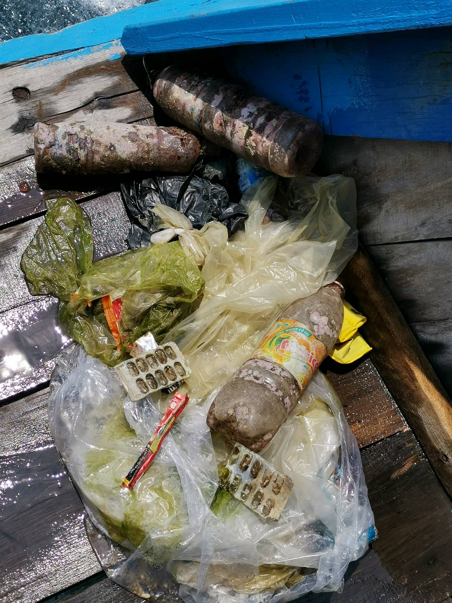
Plastic bottle
Plastic bag
0
On
kilograms
0
I have debris data to report
0
0
0
Calm (glassy to rippled) for waves 0 – 0.1 meter high
0
0
0
0
0
0
2
m2
0
0
meters
rocky reef
0
0
0
0
0
0
0
0
0
0
0
0
0
0
0
0
0
0
0
0
0
0
0
0
0
0
0
0
0
Vietnam
State\Province
Khanh Hoa
City
Van Ninh
Map Help


Dive Location

If you know your survey site coordinates, enter them manually in decimal degrees using WGS84 Map Datum. Use the minus sign for latitudes south of the equator and longitudes west of the Prime Meridian to 180 degrees.

If you do not know your survey site coordinates, click the “Map Location” tab to use the map to zoom into your survey site and drop the pin on the map to fall within your survey dive site in the water (not on land or the beach). Ensure you zoom in as much as possible to ensure data accuracy.
Entangled Help


Use the vertical tabs below to record any entangled animals you found of each type.

Junk Yard

4
15
3
sand
8
1

10.08720717509, 99.823197672398

3
1
Hair Ties
Jewelry
Eco Koh Tao - Crystal Dive
Jennifer Dowling
1
4
1
4
7
1
1
1.50
51
14.00
6.00
estimated
1
200.00
Plastic Fragments
Fishing Line
Metal Fragments
On
kilograms
I have debris data to report
Calm (glassy to rippled) for waves 0 – 0.1 meter high
5
m2
5
meters
coral reef
7
1
3
1
Thailand
State\Province
Suratthani
City
Koh Tao
Map Help


Dive Location

If you know your survey site coordinates, enter them manually in decimal degrees using WGS84 Map Datum. Use the minus sign for latitudes south of the equator and longitudes west of the Prime Meridian to 180 degrees.

If you do not know your survey site coordinates, click the “Map Location” tab to use the map to zoom into your survey site and drop the pin on the map to fall within your survey dive site in the water (not on land or the beach). Ensure you zoom in as much as possible to ensure data accuracy.
Entangled Help


Use the vertical tabs below to record any entangled animals you found of each type.

Pottery

5
6
sand
2

10.082356821898, 99.818266805857

Rain and Sun
2
Cleaning Sponges
Eco Koh Tao - Crystal Dive
Jennifer Dowling
2
1
3
7
2.50
45
12.00
6.00
estimated
3
200.00
2
1
Food wrappers
Plastic fragments
Metal fragments
On
kilograms
I have debris data to report
Calm (glassy to rippled) for waves 0 – 0.1 meter high
1
4
m2
meters
coral reef
5
1
1
1
1
Thailand
State\Province
Suratthani
City
Koh Tao
Map Help


Dive Location

If you know your survey site coordinates, enter them manually in decimal degrees using WGS84 Map Datum. Use the minus sign for latitudes south of the equator and longitudes west of the Prime Meridian to 180 degrees.

If you do not know your survey site coordinates, click the “Map Location” tab to use the map to zoom into your survey site and drop the pin on the map to fall within your survey dive site in the water (not on land or the beach). Ensure you zoom in as much as possible to ensure data accuracy.

Entangled Help


Use the vertical tabs below to record any entangled animals you found of each type.

Kerma Darat, Perhentian Island

5.937928, 102.7251888

sand
14
1
Sea Voice Divers
Sharifah
15
20
2.00
60
16.00
12.00
measured
100.00
plastic bottles
On
kilograms
I have debris data to report
Calm (glassy to rippled) for waves 0 – 0.1 meter high
1
m2
meters
rocky reef
1
Malaysia
State\Province
Terengganu
City
Perhentian Island
Map Help


Dive Location

If you know your survey site coordinates, enter them manually in decimal degrees using WGS84 Map Datum. Use the minus sign for latitudes south of the equator and longitudes west of the Prime Meridian to 180 degrees.

If you do not know your survey site coordinates, click the “Map Location” tab to use the map to zoom into your survey site and drop the pin on the map to fall within your survey dive site in the water (not on land or the beach). Ensure you zoom in as much as possible to ensure data accuracy.

Entangled Help


Use the vertical tabs below to record any entangled animals you found of each type.

Hin Wong Bay

8
19
26
sand
15

10.102019, 99.8494744

Shoes
Eco Koh Tao - Crystal Dive
Jennifer Dowling
1
6
6
18
36
2
20.00
60
16.00
8.00
7
estimated
250.00
2
Plastic bottles
Plastic fragments
Fishing Nets
1
On
kilograms
I have debris data to report
Calm (glassy to rippled) for waves 0 – 0.1 meter high
1
1
4
m2
meters
coral reef
8
3
7
2
2
6
5
Thailand
State\Province
Suratthani
City
Koh Tao
Map Help


Dive Location

If you know your survey site coordinates, enter them manually in decimal degrees using WGS84 Map Datum. Use the minus sign for latitudes south of the equator and longitudes west of the Prime Meridian to 180 degrees.

If you do not know your survey site coordinates, click the “Map Location” tab to use the map to zoom into your survey site and drop the pin on the map to fall within your survey dive site in the water (not on land or the beach). Ensure you zoom in as much as possible to ensure data accuracy.

Entangled Help


Use the vertical tabs below to record any entangled animals you found of each type.

Hin Wong Bay

10
26
2
31
2
sand
22

10.102019, 99.8494744

light bulbs
Eco Koh Tao - Cyrstal Dive
Jennifer Dowling
1
5
1
1
1
7
18
67
1
1
30.00
55
16.00
8.00
9
estimated
1
3
250.00
4
Plastic bottles
plastic fragments
fishing line
2
On
kilograms
I have debris data to report
Calm (glassy to rippled) for waves 0 – 0.1 meter high
1
5
m2
meters
coral reef
4
3
5
3
4
3
2
Thailand
State\Province
Suratthani
City
Koh Tao
Map Help


Dive Location

If you know your survey site coordinates, enter them manually in decimal degrees using WGS84 Map Datum. Use the minus sign for latitudes south of the equator and longitudes west of the Prime Meridian to 180 degrees.

If you do not know your survey site coordinates, click the “Map Location” tab to use the map to zoom into your survey site and drop the pin on the map to fall within your survey dive site in the water (not on land or the beach). Ensure you zoom in as much as possible to ensure data accuracy.

Entangled Help


Use the vertical tabs below to record any entangled animals you found of each type.

ADS548 - Sandals Reef

0
0
0

18.10754, -77.993869

0
0
1
coral
0
6
1
2
1
0
0
0
0
0
0
0
0
0
0
0
0
0
0
0
0
0
0
0
0
Sandals Southcoast
Nicholas
3
0
0
0
2
0
2
0
2
0
0
1
0
0
0
0
1
0
0
8
0
0
0
0
3
1
2
2
0
2
3
0
0
0
0.00
30
50.00
40.00
1
estimated
0
0
4290.00
0
0
0
0
0
0
On
pounds
0
I have debris data to report
0
0
0
Slight for waves 0.5 -1.25 meter high
0
0
0
0
0
0
0
ft2
0
0
feet
coral reef
0
0
0
0
0
0
0
0
0
0
0
0
0
0
0
0
0
0
0
0
0
0
0
0
0
0
0
0
Jamaica
State\Province
Westmoreland
City
Whitehouse
Map Help


Dive Location

If you know your survey site coordinates, enter them manually in decimal degrees using WGS84 Map Datum. Use the minus sign for latitudes south of the equator and longitudes west of the Prime Meridian to 180 degrees.

If you do not know your survey site coordinates, click the “Map Location” tab to use the map to zoom into your survey site and drop the pin on the map to fall within your survey dive site in the water (not on land or the beach). Ensure you zoom in as much as possible to ensure data accuracy.

Entangled Help


Use the vertical tabs below to record any entangled animals you found of each type.

ADS535 - Bigth Reef

3
0
0

21.786222, -72.212212085724

0
0
0
coral
0
7
0
0
2
0
0
0
0
0
0
0
0
0
0
0
0
0
0
0
0
0
0
0
0
Beaches Turks and Caicos
Mark Healey
3
0
3
3
0
0
0
0
0
0
0
0
0
0
0
0
0
0
0
2
0
0
0
0
4
1
3
1
0
0
0
0
0
0
0.00
30
35.00
30.00
0
estimated
0
0
100.00
0
0
0
0
0
0
On
pounds
0
I have debris data to report
0
0
0
Smooth (wavelets) for waves 0.1 - 0.5 meter high
0
0
0
0
0
0
0
ft2
0
0
meters
coral reef
0
0
0
0
0
0
0
0
0
0
0
0
0
0
0
0
0
0
0
0
0
0
0
0
0
0
0
0
Turks and Caicos Islands
Map Help


Dive Location

If you know your survey site coordinates, enter them manually in decimal degrees using WGS84 Map Datum. Use the minus sign for latitudes south of the equator and longitudes west of the Prime Meridian to 180 degrees.

If you do not know your survey site coordinates, click the “Map Location” tab to use the map to zoom into your survey site and drop the pin on the map to fall within your survey dive site in the water (not on land or the beach). Ensure you zoom in as much as possible to ensure data accuracy.

Entangled Help


Use the vertical tabs below to record any entangled animals you found of each type.

ADS534 - Shallow Plane

0
0
0

18.313369, -78.366275

0
0
0
coral
0
0
0
0
0
Calm
0
0
0
0
0
0
0
0
0
0
0
0
0
0
0
0
0
0
0
0
Beaches Negril
Glenroy Graham
0
0
0
0
0
0
0
0
0
0
0
0
0
0
0
0
0
0
0
6
0
0
0
0
0
0
0
0
0
0
0
0
0
0
0.00
30
40.00
30.00
0
estimated
0
0
248.00
0
0
0
0
0
0
On
kilograms
0
Our Survey Site was free of debris
0
0
0
Calm (glassy to rippled) for waves 0 – 0.1 meter high
0
0
0
0
0
0
0
m2
0
0
meters
coral reef
0
0
0
0
0
0
0
0
0
0
0
0
0
0
0
0
0
0
0
0
0
0
0
0
0
0
0
0
Jamaica
State\Province
Westmoreland
City
Negril
Map Help


Dive Location

If you know your survey site coordinates, enter them manually in decimal degrees using WGS84 Map Datum. Use the minus sign for latitudes south of the equator and longitudes west of the Prime Meridian to 180 degrees.

If you do not know your survey site coordinates, click the “Map Location” tab to use the map to zoom into your survey site and drop the pin on the map to fall within your survey dive site in the water (not on land or the beach). Ensure you zoom in as much as possible to ensure data accuracy.

Entangled Help


Use the vertical tabs below to record any entangled animals you found of each type.

Subscribe to