Menu

Deerfield Beach Fishing Pier

22
34
5
sand
5236

26.3164522, -80.074169

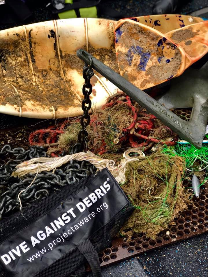
One by one by one... A world record is broken. (WORLD RECORD DIVE AGAINST DEBRIS EVENT)

633 divers. 2700lbs of fishing gear. Over 9,000 pieces of marine debris reported to Project AWARE. To say today's collaboration of The World Record Clean Up Event hosted by Dixie Divers was a success is an understatement.

Hundreds of Divers under the support of PADI, Project AWARE, many other dive centers, community members, and more, all came together to make Deerfield Beach a better place for all who live there, above and below the waves.

What an amazing day for Conservation and an amazing day for the dive community.
This was part of the successful World Record Clean Up Event in Deerfield Beach Florida
Metal Gym Weights (45lbs)
Calm, few waves in late afternoon, early morning very calm
2
6
1
12
Boat Hook
Metal Pliers
Metal Gym Weights and equipment
fishing rod METAL
Dixie Divers
Pavan Arilton
2
633
2
3
2572.20
55
20.00
2.00
measured
3
2
5126
115728.00
Fishing Sinkers
Fishing Monofilament line
Fishing Traps
On
pounds
I have debris data to report
12
Calm (glassy to rippled) for waves 0 – 0.1 meter high ft2
12
feet
rocky reef
24
13
2
13
United States
State\Province
Florida
City
Deerfield Beach
Map Help


Dive Location

If you know your survey site coordinates, enter them manually in decimal degrees using WGS84 Map Datum. Use the minus sign for latitudes south of the equator and longitudes west of the Prime Meridian to 180 degrees.

If you do not know your survey site coordinates, click the “Map Location” tab to use the map to zoom into your survey site and drop the pin on the map to fall within your survey dive site in the water (not on land or the beach). Ensure you zoom in as much as possible to ensure data accuracy.

Entangled Help


Use the vertical tabs below to record any entangled animals you found of each type.

ADS426 - House Reef Outrigger Konotta Maldives

0.46258801100945, 73.156623343355

rock
2
2
The strong winds and stormy weather could have lead to transplantation of debris from deeper ocean away from the reef. Also we are having some villa refurbishments near the location so some building material could have infiltrated into the reef environment more easily.
Some stormy weather, strong winds, white caps, slight waves.
Best Dives Maldives
Amelia Cody
2
3
3
15.00
45
20.00
5.00
estimated
250.00
Metal rods/pipes
On
kilograms
I have debris data to report
2
Slight for waves 0.5 -1.25 meter high
2
4
2
m2
3
meters
coral reef
2
1
3
4
1
1
2
2
1
Maldives
Map Help


Dive Location

If you know your survey site coordinates, enter them manually in decimal degrees using WGS84 Map Datum. Use the minus sign for latitudes south of the equator and longitudes west of the Prime Meridian to 180 degrees.

If you do not know your survey site coordinates, click the “Map Location” tab to use the map to zoom into your survey site and drop the pin on the map to fall within your survey dive site in the water (not on land or the beach). Ensure you zoom in as much as possible to ensure data accuracy.

Entangled Help


Use the vertical tabs below to record any entangled animals you found of each type.

ADS54 - Mosquito Pier

2

18.148768, -65.514533

1
sand
83
headlamp
varied: some rain, high heat, moderate winds
1
2
1
1
1
5
bullet casing
knife
sunglasses
headlamp
electric cable
spark plug
Isla Nena Scuba
Tania Puell
1
1
2
12
15.20
61
40.00
5.00
measured
279
153399.00
8
fishng line
fishing hooks
fishing sinkers
On
pounds
I have debris data to report
4
Smooth (wavelets) for waves 0.1 - 0.5 meter high
3
ft2
feet
other
5
1
1
2
United States
State\Province
PR
City
Vieques
Map Help


Dive Location

If you know your survey site coordinates, enter them manually in decimal degrees using WGS84 Map Datum. Use the minus sign for latitudes south of the equator and longitudes west of the Prime Meridian to 180 degrees.

If you do not know your survey site coordinates, click the “Map Location” tab to use the map to zoom into your survey site and drop the pin on the map to fall within your survey dive site in the water (not on land or the beach). Ensure you zoom in as much as possible to ensure data accuracy.

Entangled Help


Use the vertical tabs below to record any entangled animals you found of each type.

Ecosystem Other
man made environment: pier

ACE Wreck

2
3
24
sand
2
120
2

33.398241644125, -117.66425271646

This is an actual wreck that sunk 10 years ago. We have started the process of removing the items that were originally on the boat. But, it is apparent that the area is being fished quite a bit.
We pulled up two boat anchors from a different boat.
Fish caught on a lure and unable to release. We were able to catch him and remove the hook.
Clear with overcast. Light rains
Beach Cities Scuba
D.J. Mansfield
2
1
12
1
2
186.00
40
121.00
80.00
70
measured
3
1800.00
Fishing Line
Boat Lines
Plastic debris from fishermen
On
pounds
I have debris data to report
1
Calm (glassy to rippled) for waves 0 – 0.1 meter high
Released Unharmed
Sand Bass
1
Fishing Line
ft2
feet
other
1
2
United States
State\Province
CA
City
Dana Point
Map Help


Dive Location

If you know your survey site coordinates, enter them manually in decimal degrees using WGS84 Map Datum. Use the minus sign for latitudes south of the equator and longitudes west of the Prime Meridian to 180 degrees.

If you do not know your survey site coordinates, click the “Map Location” tab to use the map to zoom into your survey site and drop the pin on the map to fall within your survey dive site in the water (not on land or the beach). Ensure you zoom in as much as possible to ensure data accuracy.

Entangled Help


Use the vertical tabs below to record any entangled animals you found of each type.

Ecosystem Other
Wreck

ADS370 - Blue Bay The Wall & The Garden

11

12.134409, -68.985034

coral
2
1
1
5
2
4
1
3.10
49
17.00
2.00
measured
400.00
1
On
kilograms
I have debris data to report
7
Smooth (wavelets) for waves 0.1 - 0.5 meter high m2
meters
coral reef
1
3
1
3
1
Netherlands Antilles
Map Help


Dive Location

If you know your survey site coordinates, enter them manually in decimal degrees using WGS84 Map Datum. Use the minus sign for latitudes south of the equator and longitudes west of the Prime Meridian to 180 degrees.

If you do not know your survey site coordinates, click the “Map Location” tab to use the map to zoom into your survey site and drop the pin on the map to fall within your survey dive site in the water (not on land or the beach). Ensure you zoom in as much as possible to ensure data accuracy.

Entangled Help


Use the vertical tabs below to record any entangled animals you found of each type.

ADS106 - Aquarium

0
0
0

25.012948997561, -80.380714

0
0
0
coral
0
0
0
0
0
Lobster season/storms/boaters
Side wall of trap
Calm
0
0
0
0
0
0
0
0
0
0
0
0
0
0
0
0
0
0
0
0
Rainbow Reef Dive Center/Florida Keys National Marine Sanctuary
John Doud
0
0
0
0
0
0
0
0
0
0
0
0
0
0
0
0
0
0
0
1
0
0
0
0
0
0
0
0
0
0
0
0
0
0
1.00
45
30.00
20.00
0
estimated
1
0
650.00
0
0
0
0
0
0
On
kilograms
0
I have debris data to report
0
0
0
Smooth (wavelets) for waves 0.1 - 0.5 meter high
0
0
0
0
0
0
0
ft2
0
0
feet
coral reef
0
0
0
0
0
0
0
0
0
0
0
0
0
0
0
0
0
0
0
0
0
0
0
0
0
0
0
0
United States
State\Province
FL
City
Key Largo
Map Help


Dive Location

If you know your survey site coordinates, enter them manually in decimal degrees using WGS84 Map Datum. Use the minus sign for latitudes south of the equator and longitudes west of the Prime Meridian to 180 degrees.

If you do not know your survey site coordinates, click the “Map Location” tab to use the map to zoom into your survey site and drop the pin on the map to fall within your survey dive site in the water (not on land or the beach). Ensure you zoom in as much as possible to ensure data accuracy.

Entangled Help


Use the vertical tabs below to record any entangled animals you found of each type.

ADS31 - Spiegel Grove

0
0
0

25.066259, -80.311979

0
0
0
coral
0
0
0
1
0
Fishing
25 ft of fishing line
Calm
0
0
0
0
0
0
0
0
0
0
0
0
0
0
0
0
0
0
0
0
Rainbow Reef Dive Center/Florida Keys National Marine Sanctuary
Lucy Ledebach
0
0
0
0
0
0
0
0
0
0
0
0
0
0
0
0
0
0
0
1
0
0
0
0
0
0
0
0
0
0
0
0
0
0
0.30
25
100.00
80.00
0
estimated
0
0
600.00
0
0
0
0
0
0
On
kilograms
0
I have debris data to report
0
0
0
Smooth (wavelets) for waves 0.1 - 0.5 meter high
0
0
0
0
0
0
0
ft2
0
0
feet
coral reef
0
0
0
0
0
0
0
0
0
0
0
0
0
0
0
0
0
0
0
0
0
0
0
0
0
0
0
0
United States
State\Province
FL
City
Key Largo
Map Help


Dive Location

If you know your survey site coordinates, enter them manually in decimal degrees using WGS84 Map Datum. Use the minus sign for latitudes south of the equator and longitudes west of the Prime Meridian to 180 degrees.

If you do not know your survey site coordinates, click the “Map Location” tab to use the map to zoom into your survey site and drop the pin on the map to fall within your survey dive site in the water (not on land or the beach). Ensure you zoom in as much as possible to ensure data accuracy.

Entangled Help


Use the vertical tabs below to record any entangled animals you found of each type.

Exiles

0
0
0
0
0
0
0
rock
0
0
0
0
0

35.918539924497, 14.498552083969

Dive Systems
Tom
0
0
0
0
0
0
0
0
0
0
0
0
0
0
0
0
0
0
0
5
0
0
0
0
0
0
0
0
0
0
0
0
0
0
0
0
0.00
40
7.00
2.00
0
estimated
0
0
0
0
2000.00
0
0
0
0
0
Plastic
Bottles
Metal part
0
On
kilograms
0
Our Survey Site was free of debris
0
0
0
Calm (glassy to rippled) for waves 0 – 0.1 meter high
0
0
0
Released Unharmed
0
0
0
0
m2
0
0
1
Not provided
Octopus
Released Unharmed
meters
seagrass
0
0
0
0
0
0
0
0
0
0
0
0
0
0
0
0
0
0
0
0
0
0
0
0
0
0
0
0
0
Malta
City
Sliema
Map Help


Dive Location

If you know your survey site coordinates, enter them manually in decimal degrees using WGS84 Map Datum. Use the minus sign for latitudes south of the equator and longitudes west of the Prime Meridian to 180 degrees.

If you do not know your survey site coordinates, click the “Map Location” tab to use the map to zoom into your survey site and drop the pin on the map to fall within your survey dive site in the water (not on land or the beach). Ensure you zoom in as much as possible to ensure data accuracy.

Entangled Help


Use the vertical tabs below to record any entangled animals you found of each type.

ADS111 - North Star

0
0
0

25.010285, -80.373301

0
0
0
coral
0
1
0
1
0
Calm
1
0
0
0
0
0
0
0
0
0
0
0
0
0
0
0
0
0
0
0
Hair tie
Rainbow Reef Dive Center/Florida Keys National Marine Sanctuary
Hailey Metz
0
0
0
0
0
0
0
0
0
0
0
0
0
0
0
0
0
0
0
1
0
0
0
0
0
0
0
0
0
0
0
0
0
0
0.20
45
30.00
25.00
0
estimated
0
1
1000.00
0
0
0
0
0
0
On
pounds
0
I have debris data to report
0
0
0
Smooth (wavelets) for waves 0.1 - 0.5 meter high
0
0
0
0
0
0
0
ft2
0
0
feet
coral reef
0
0
0
0
0
0
0
0
0
0
0
0
0
0
0
0
0
0
0
0
0
0
0
0
0
0
0
0
United States
State\Province
florida
City
key largo
Map Help


Dive Location

If you know your survey site coordinates, enter them manually in decimal degrees using WGS84 Map Datum. Use the minus sign for latitudes south of the equator and longitudes west of the Prime Meridian to 180 degrees.

If you do not know your survey site coordinates, click the “Map Location” tab to use the map to zoom into your survey site and drop the pin on the map to fall within your survey dive site in the water (not on land or the beach). Ensure you zoom in as much as possible to ensure data accuracy.

Entangled Help


Use the vertical tabs below to record any entangled animals you found of each type.

ADS105 - French Twist

0
0
0

25.034283001091, -80.34821667

0
0
0
coral
0
0
0
0
0
Calm
0
0
0
0
0
0
0
0
0
0
0
0
0
0
0
0
0
0
0
0
Rainbow Reef Dive Center/Florida Keys National Marine Sanctuary
Kirk Mcfarlin
0
0
0
0
0
0
0
0
0
0
0
0
0
0
0
0
0
0
0
1
0
0
0
0
0
0
0
0
0
0
0
0
0
0
0.00
45
35.00
25.00
0
estimated
0
0
300.00
0
0
0
0
0
0
On
kilograms
0
Our Survey Site was free of debris
0
0
0
Smooth (wavelets) for waves 0.1 - 0.5 meter high
0
0
0
0
0
0
0
ft2
0
0
feet
coral reef
0
0
0
0
0
0
0
0
0
0
0
0
0
0
0
0
0
0
0
0
0
0
0
0
0
0
0
0
United States
State\Province
FL
City
Key Largo
Map Help


Dive Location

If you know your survey site coordinates, enter them manually in decimal degrees using WGS84 Map Datum. Use the minus sign for latitudes south of the equator and longitudes west of the Prime Meridian to 180 degrees.

If you do not know your survey site coordinates, click the “Map Location” tab to use the map to zoom into your survey site and drop the pin on the map to fall within your survey dive site in the water (not on land or the beach). Ensure you zoom in as much as possible to ensure data accuracy.

Entangled Help


Use the vertical tabs below to record any entangled animals you found of each type.

Subscribe to