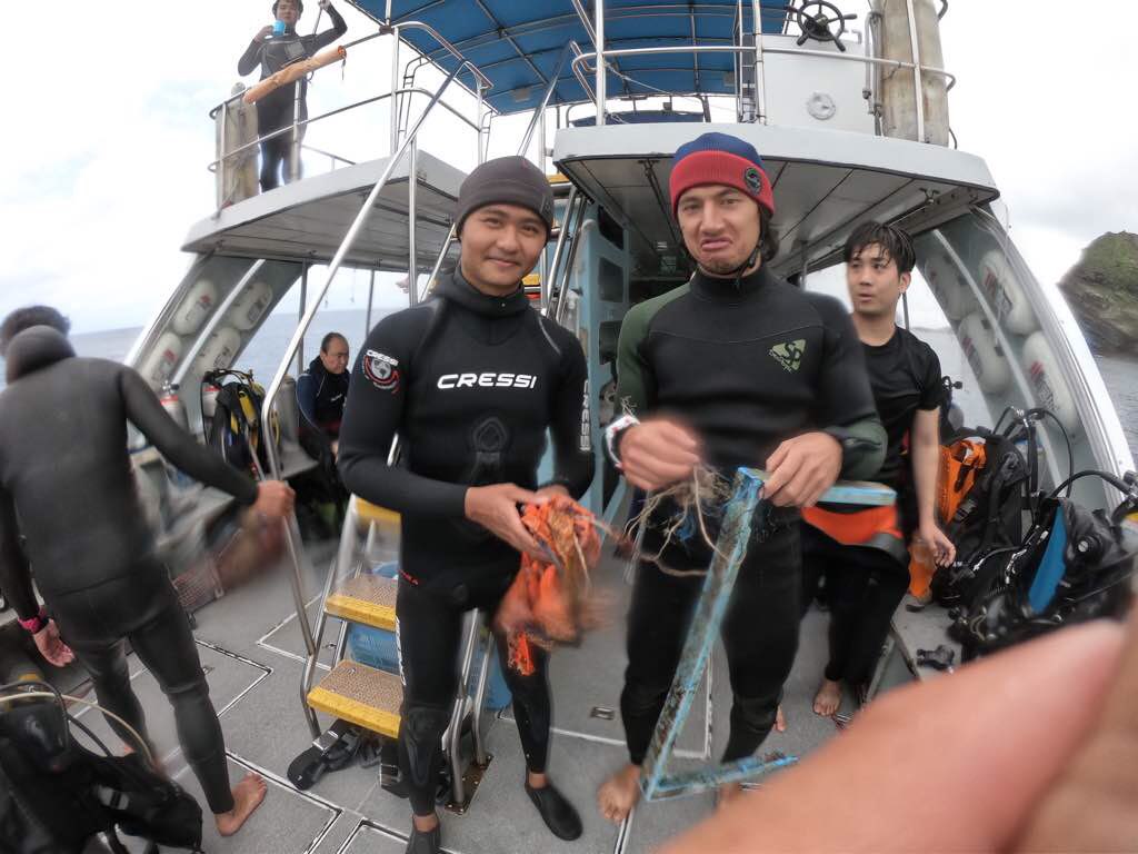
All the debris was found caught on the walls of the cave/tunnel.
Debris being trapped in a cave. Rope, fishing line, pieces of plastic entering through a current.
Broken piece of plastic from what looks like a basket.
0
0
0
0
0
0
0
0
0
0
0
0
0
0
0
0
0
0
0
0
SEASIR
Nolan Cobin
0
0
0
0
0
0
0
0
0
0
0
0
0
0
0
0
0
0
0
2
0
0
0
0
0
0
0
0
1
0
0
0
0
0
0.50
35
10.00
5.00
3
estimated
0
0
86.37
0
0
0
0
0
Rope
Fishing net/line
0
On
kilograms
0
I have debris data to report
0
0
0
Smooth (wavelets) for waves 0.1 - 0.5 meter high
0
0
0
0
0
0
0
m2
0
0
meters
coral reef
0
0
0
0
0
0
0
0
0
0
0
0
0
0
0
0
0
0
0
0
0
0
0
0
0
0
0
0
Japan
State\Province
Okinawa
Map Help
Dive Location
If you know your survey site coordinates, enter them manually in decimal degrees using WGS84 Map Datum. Use the minus sign for latitudes south of the equator and longitudes west of the Prime Meridian to 180 degrees.
If you do not know your survey site coordinates, click the “Map Location” tab to use the map to zoom into your survey site and drop the pin on the map to fall within your survey dive site in the water (not on land or the beach). Ensure you zoom in as much as possible to ensure data accuracy.
Entangled Help
Use the vertical tabs below to record any entangled animals you found of each type.
Calm (glassy to rippled) for waves 0 – 0.1 meter high
0
0
0
0
0
0
0
m2
0
0
feet
rocky reef
0
0
0
0
0
0
0
0
0
0
0
0
0
0
0
0
0
0
0
0
0
0
0
0
0
0
0
0
0
Language
English
United States
State\Province
Washington
City
Hoodsport
Map Help
Dive Location
If you know your survey site coordinates, enter them manually in decimal degrees using WGS84 Map Datum. Use the minus sign for latitudes south of the equator and longitudes west of the Prime Meridian to 180 degrees.
If you do not know your survey site coordinates, click the “Map Location” tab to use the map to zoom into your survey site and drop the pin on the map to fall within your survey dive site in the water (not on land or the beach). Ensure you zoom in as much as possible to ensure data accuracy.
Entangled Help
Use the vertical tabs below to record any entangled animals you found of each type.
Calm (glassy to rippled) for waves 0 – 0.1 meter high
0
0
0
0
0
0
0
ft2
0
0
feet
other
0
0
0
0
0
0
0
0
0
0
0
0
0
0
0
0
0
0
0
0
0
0
0
0
0
0
0
0
0
Language
English
United States
State\Province
UT
City
Orangeville
Map Help
Dive Location
If you know your survey site coordinates, enter them manually in decimal degrees using WGS84 Map Datum. Use the minus sign for latitudes south of the equator and longitudes west of the Prime Meridian to 180 degrees.
If you do not know your survey site coordinates, click the “Map Location” tab to use the map to zoom into your survey site and drop the pin on the map to fall within your survey dive site in the water (not on land or the beach). Ensure you zoom in as much as possible to ensure data accuracy.
Entangled Help
Use the vertical tabs below to record any entangled animals you found of each type.
We found a lot of rubber pipe/hose. We suggest adding that as a category of debris. We logged it as rubber fragments as they were fragmented pieces of pipe.
very old Schick electric razor; baby doll face
1
1
Tennis Racquet
Traffic Cone
Seattle Dive Tours
Scot Flaherty
1
5
4
7
1
9
1
1
9
2
1
1
94.00
45
75.00
20.00
measured
2
2386.00
1
1
17
Tire
On
pounds
I have debris data to report
3
Smooth (wavelets) for waves 0.1 - 0.5 meter high
1
4
4
m2
2
1
feet
rocky reef
3
7
3
2
1
2
1
10
1
2
Language
English
United States
State\Province
Washington
City
Seattle
Map Help
Dive Location
If you know your survey site coordinates, enter them manually in decimal degrees using WGS84 Map Datum. Use the minus sign for latitudes south of the equator and longitudes west of the Prime Meridian to 180 degrees.
If you do not know your survey site coordinates, click the “Map Location” tab to use the map to zoom into your survey site and drop the pin on the map to fall within your survey dive site in the water (not on land or the beach). Ensure you zoom in as much as possible to ensure data accuracy.
Entangled Help
Use the vertical tabs below to record any entangled animals you found of each type.
The site is immediately down stream from the dam. I expect there will be much to clean up as the water subsides.
Flooding is happening around the area.
Plastic Patio Umbrella stand
Lots of rain
1
Patio umbrella stand
Dive Kawartha
Kristopher T. Reynolds
1
0
0
0
0
0
0
0
0
0
4
0
0
0
0
0
0
4
0
2
0
0
1
0
0
0
5
0
0
0
0
0
0
0
0
0
68.00
68
39.00
6.00
0
measured
0
0
0
0
2535.00
0
1
0
0
0
Plastic bottles
Fishing line & lures
Tires
0
On
pounds
0
I have debris data to report
1
0
0
Slight for waves 0.5 -1.25 meter high
0
0
1
0
0
0
0
m2
0
0
feet
other
1
0
0
0
0
1
0
0
0
2
0
0
0
0
0
0
0
0
0
0
0
0
2
0
2
0
0
0
0
Language
English
Canada
State\Province
Ontario
City
Marmora
Map Help
Dive Location
If you know your survey site coordinates, enter them manually in decimal degrees using WGS84 Map Datum. Use the minus sign for latitudes south of the equator and longitudes west of the Prime Meridian to 180 degrees.
If you do not know your survey site coordinates, click the “Map Location” tab to use the map to zoom into your survey site and drop the pin on the map to fall within your survey dive site in the water (not on land or the beach). Ensure you zoom in as much as possible to ensure data accuracy.
Entangled Help
Use the vertical tabs below to record any entangled animals you found of each type.