Menu

Kubbar Island

19

29.070418, 48.489498

coral
1

29.0719656, 48.492609

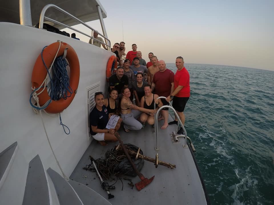
Our dive center in cooperation with american military base in Kuwait scheduled net clean up event on 30th of december 2018.
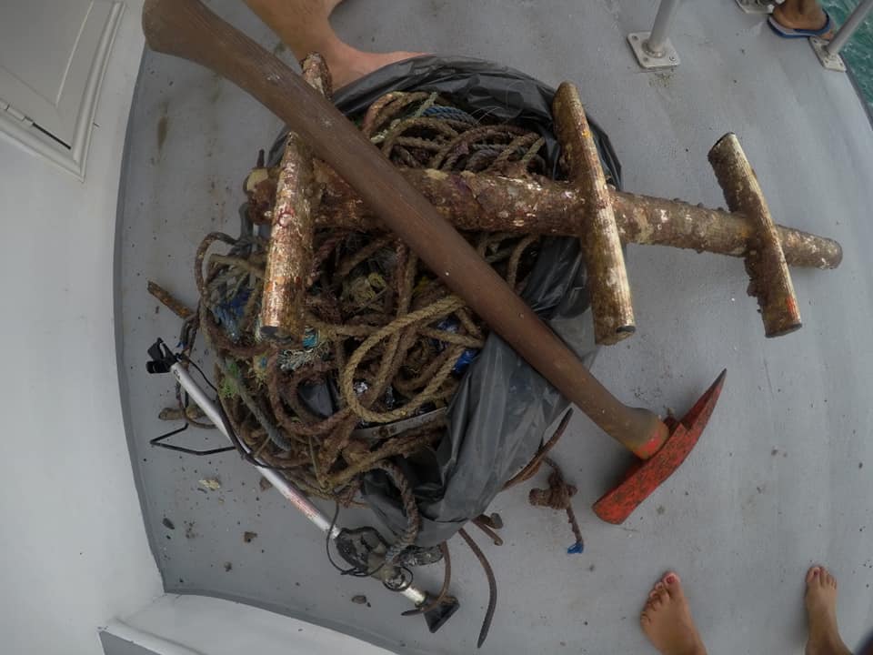
Firefighter Ax, boat leader, spearfishing gun
31 degrees C air
28 degrees C water
wind 6 knots
no waves/currents/surf
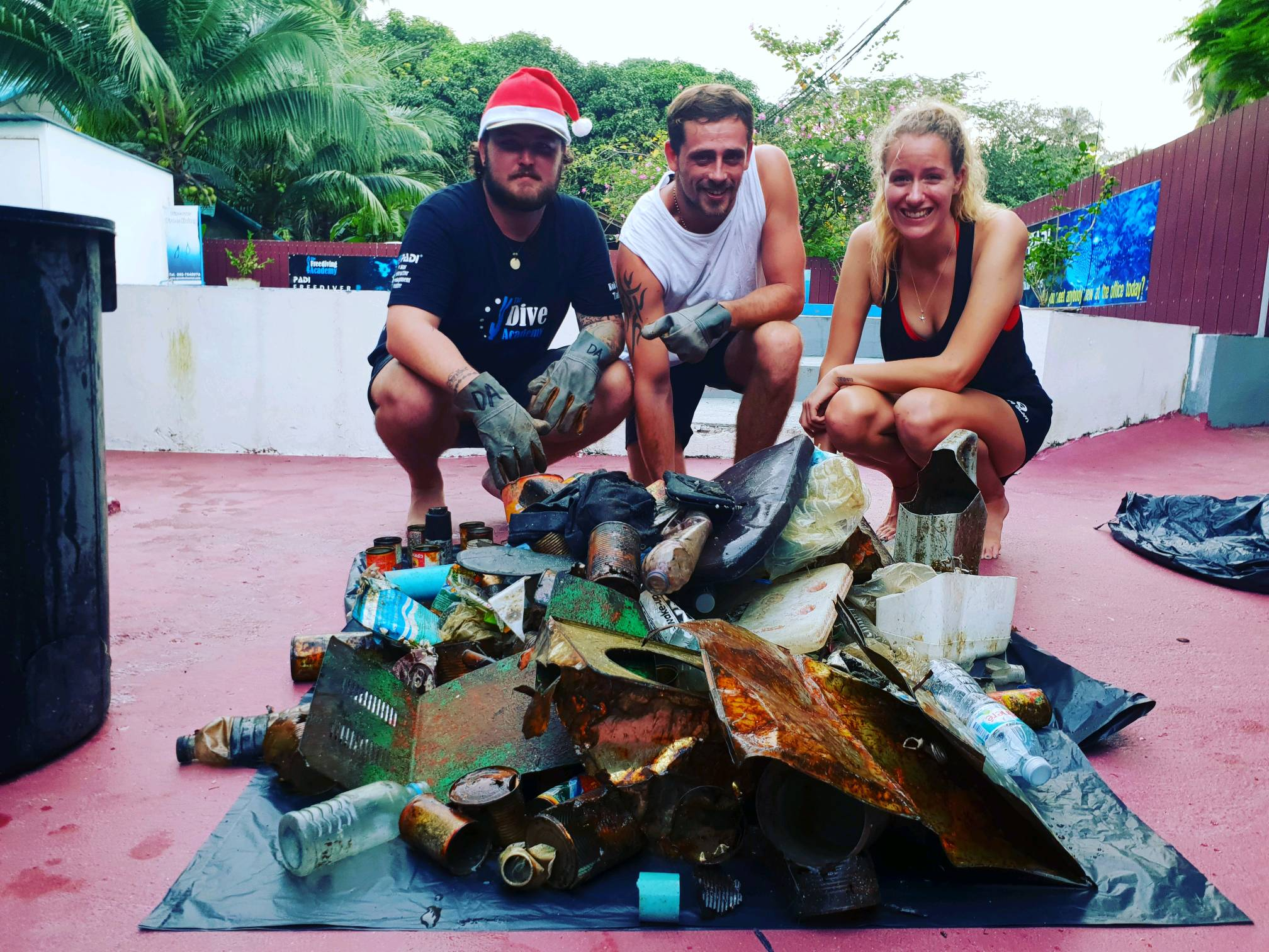
The Palms Dive center
Zhanyla Noruzbaeva
4
5
1
21
3
7
25.00
51
10.00
5.00
measured
29
4
2500.00
Fishing lines, robes, hooks
Plastic bottels and bags
Glass bottles and fast food packeging
On
kilograms
I have debris data to report
7
Calm (glassy to rippled) for waves 0 – 0.1 meter high
1
1
m2
31
meters
coral reef
14
3
1
10
Kuwait
City
kuwait
Map Help


Dive Location

If you know your survey site coordinates, enter them manually in decimal degrees using WGS84 Map Datum. Use the minus sign for latitudes south of the equator and longitudes west of the Prime Meridian to 180 degrees.

If you do not know your survey site coordinates, click the “Map Location” tab to use the map to zoom into your survey site and drop the pin on the map to fall within your survey dive site in the water (not on land or the beach). Ensure you zoom in as much as possible to ensure data accuracy.

Entangled Help


Use the vertical tabs below to record any entangled animals you found of each type.

ADS440 - Bulcock Beach

2
14
0
1

-26.806313, 153.130415

47
0
0
rock
0
2
0
0
0
No
Slinky toy
1
2
1
1
Half scissors
Hair tie
Gas stove lighter
Camping knife
Sunshine Coast Clean Up Divers
Elliot Peters
0
0
0
1
0
0
0
0
0
0
0
0
0
0
0
0
0
0
0
6
0
0
2
0
0
0
2
0
59
0
0
0
0
0
0
0
18.60
60
8.00
1.00
1
measured
0
0
0
288
8167.47
0
0
0
0
0
Fishing line
Casting net
Fishing tackle
1
On
kilograms
0
I have debris data to report
1
0
0
Calm (glassy to rippled) for waves 0 – 0.1 meter high
1
0
1
Casting net
Released Unharmed
No idea
Unknown
Released Unharmed
3
6
Casting net
0
6
0
0
m2
34
0
meters
rocky reef
0
0
0
0
0
0
0
1
0
0
1
0
0
0
0
14
0
3
0
0
1
0
0
0
1
0
0
0
0
Australia
State\Province
Queensland
City
Caloundra
Map Help


Dive Location

If you know your survey site coordinates, enter them manually in decimal degrees using WGS84 Map Datum. Use the minus sign for latitudes south of the equator and longitudes west of the Prime Meridian to 180 degrees.

If you do not know your survey site coordinates, click the “Map Location” tab to use the map to zoom into your survey site and drop the pin on the map to fall within your survey dive site in the water (not on land or the beach). Ensure you zoom in as much as possible to ensure data accuracy.

Entangled Help


Use the vertical tabs below to record any entangled animals you found of each type.

Japanese Garden

5
5
7
0

10.118571, 99.814548

0
1
0
coral
0
37
1
3
2
We all had great fun!!
No
The participants: Shannon Witter, Jack Morten and Corey Roulent were completing DAD Specialty Instructor training
Monsoon Rain
The Dive Academy
Paul Meredith
3
6
2
0
0
0
0
0
3
0
0
0
0
0
0
0
1
3
0
4
0
0
0
0
0
0
18
0
0
2
0
0
0
0
0
0
18.00
80
7.00
3.00
0
measured
0
0
0
2
11668.20
0
0
0
0
0
Food Cans
Plastic bottles
Plastic bags
0
On
kilograms
0
I have debris data to report
1
0
0
Calm (glassy to rippled) for waves 0 – 0.1 meter high
4
0
3
0
0
3
0
m2
6
0
meters
coral reef
1
0
3
5
0
0
0
0
0
2
2
0
0
0
0
1
118
0
0
5
10
0
13
0
0
0
7
0
0
Thailand
State\Province
Suratthani
City
Koh Tao
Map Help


Dive Location

If you know your survey site coordinates, enter them manually in decimal degrees using WGS84 Map Datum. Use the minus sign for latitudes south of the equator and longitudes west of the Prime Meridian to 180 degrees.

If you do not know your survey site coordinates, click the “Map Location” tab to use the map to zoom into your survey site and drop the pin on the map to fall within your survey dive site in the water (not on land or the beach). Ensure you zoom in as much as possible to ensure data accuracy.

Entangled Help


Use the vertical tabs below to record any entangled animals you found of each type.

ADS203 - Desnogorsk

54.153811, 33.252289

sand
Akvanavt
German G Gurskiy
6
0.00
24
6.00
1.50
estimated
2000.00
On
kilograms
Our Survey Site was free of debris
Calm (glassy to rippled) for waves 0 – 0.1 meter high m2
meters
seagrass
Russia
Map Help


Dive Location

If you know your survey site coordinates, enter them manually in decimal degrees using WGS84 Map Datum. Use the minus sign for latitudes south of the equator and longitudes west of the Prime Meridian to 180 degrees.

If you do not know your survey site coordinates, click the “Map Location” tab to use the map to zoom into your survey site and drop the pin on the map to fall within your survey dive site in the water (not on land or the beach). Ensure you zoom in as much as possible to ensure data accuracy.

Entangled Help


Use the vertical tabs below to record any entangled animals you found of each type.

Na'ama Bay House Reef

109
sand
7

27.909270685559, 34.327167238626

We were lucky to welcome this fantastic group of divers from the UAE, who were partly sponsored by their employer HSBC, for their trip which sole purpose was to help clean underwater in Sharm el Sheikh.

The amazing multinational group enjoyed three days of diving, including a trip to the SS Thistlegorm (where no debris was collected :)).

In total they collected over 50 kg of debris from the Red Sea.

Camel Dive Club enjoyed this extremely unique trip and we look forward to welcoming them back soon for more clean up adventures.
Camel Dive Club & Hotel
Beth Sanders
9
28
17
65
47.50
60
18.00
2.00
measured
500.00
On
kilograms
I have debris data to report
18
Moderate to rough for waves greater than 1.25 meters m2
7
meters
coral reef
18
3
13
5
Egypt
State\Province
Sinai
City
Sharm el Sheikh
Map Help


Dive Location

If you know your survey site coordinates, enter them manually in decimal degrees using WGS84 Map Datum. Use the minus sign for latitudes south of the equator and longitudes west of the Prime Meridian to 180 degrees.

If you do not know your survey site coordinates, click the “Map Location” tab to use the map to zoom into your survey site and drop the pin on the map to fall within your survey dive site in the water (not on land or the beach). Ensure you zoom in as much as possible to ensure data accuracy.

Entangled Help


Use the vertical tabs below to record any entangled animals you found of each type.

Temple

2
50
4
coral
1
4

27.789440545272, 34.261013605846

We were lucky to welcome this fantastic group of divers from the UAE, who were partly sponsored by their employer HSBC, for their trip which sole purpose was to help clean underwater in Sharm el Sheikh.

The amazing multinational group enjoyed three days of diving, including a trip to the SS Thistlegorm (where no debris was collected :)).

In total, they collected over 50 kg of debris from the Red Sea.

Camel Dive Club enjoyed this extremely unique trip and we look forward to welcoming them back soon for more clean up adventures.


a hairbrush and a nose clip
Calm and sunny
Camel Dive Club & Hotel
Beth Sanders
3
9
17
9
2
16
1
3.50
60
24.00
2.00
measured
200.00
2
Plastic fragments
On
kilograms
I have debris data to report
Smooth (wavelets) for waves 0.1 - 0.5 meter high
18
12
m2
1
meters
coral reef
1
1
Egypt
State\Province
Sinai
City
Sharm el Sheikh
Map Help


Dive Location

If you know your survey site coordinates, enter them manually in decimal degrees using WGS84 Map Datum. Use the minus sign for latitudes south of the equator and longitudes west of the Prime Meridian to 180 degrees.

If you do not know your survey site coordinates, click the “Map Location” tab to use the map to zoom into your survey site and drop the pin on the map to fall within your survey dive site in the water (not on land or the beach). Ensure you zoom in as much as possible to ensure data accuracy.

Entangled Help


Use the vertical tabs below to record any entangled animals you found of each type.

ADS426 - House Reef Outrigger Konotta Maldives

4
4

0.46258801100945, 73.156623343355

sand
Another one is released unharmed
sunny
Bestdives Maldives, Konotta
Joan Li
25
1
67
7
1
14
7
65.00
60
5.00
1.00
2
estimated
100.00
1
3
On
kilograms
I have debris data to report
32
Calm (glassy to rippled) for waves 0 – 0.1 meter high
1
2
Dead
Sargassum Frogfish
1
Plastic strappings
3
1
m2
meters
coral reef
15
2
6
3
Maldives
Map Help


Dive Location

If you know your survey site coordinates, enter them manually in decimal degrees using WGS84 Map Datum. Use the minus sign for latitudes south of the equator and longitudes west of the Prime Meridian to 180 degrees.

If you do not know your survey site coordinates, click the “Map Location” tab to use the map to zoom into your survey site and drop the pin on the map to fall within your survey dive site in the water (not on land or the beach). Ensure you zoom in as much as possible to ensure data accuracy.

Entangled Help


Use the vertical tabs below to record any entangled animals you found of each type.

ADS432 - Laem Thian

7
7
sand
2
27
4

10.088037983773, 99.853762240467

Storms
Master Divers
Charlie
3
2
11
1
25
1
1
6.00
50
18.00
7.00
13
measured
30.00
1
1
On
kilograms
I have debris data to report
2
Smooth (wavelets) for waves 0.1 - 0.5 meter high
3
m2
2
meters
coral reef
1
4
1
1
1
Thailand
State\Province
Surat Thani
City
Koh Tao
Map Help


Dive Location

If you know your survey site coordinates, enter them manually in decimal degrees using WGS84 Map Datum. Use the minus sign for latitudes south of the equator and longitudes west of the Prime Meridian to 180 degrees.

If you do not know your survey site coordinates, click the “Map Location” tab to use the map to zoom into your survey site and drop the pin on the map to fall within your survey dive site in the water (not on land or the beach). Ensure you zoom in as much as possible to ensure data accuracy.

Entangled Help


Use the vertical tabs below to record any entangled animals you found of each type.

ADS487 - Hin Yetti

4
13
5

11.63, 102.54

sand
7
13
1
Calm, no rain, no waves
BB divers Koh Kood
Manu
1
2
1
3
6
2
1
10.00
270
7.00
3.00
9
estimated
20.00
1
plasic
fishing ner
On
kilograms
I have debris data to report
4
Calm (glassy to rippled) for waves 0 – 0.1 meter high
0
0
3
m2
meters
coral reef
3
1
3
1
2
Thailand
State\Province
Trat
City
Ngamkgo Koh Kood
Map Help


Dive Location

If you know your survey site coordinates, enter them manually in decimal degrees using WGS84 Map Datum. Use the minus sign for latitudes south of the equator and longitudes west of the Prime Meridian to 180 degrees.

If you do not know your survey site coordinates, click the “Map Location” tab to use the map to zoom into your survey site and drop the pin on the map to fall within your survey dive site in the water (not on land or the beach). Ensure you zoom in as much as possible to ensure data accuracy.

Entangled Help


Use the vertical tabs below to record any entangled animals you found of each type.

ADS54 - Mosquito Pier

3
1

18.148768, -65.514533

seagrass
32

18.148451957473, -65.514195098583

none
nothing unusual
variegated
3
5
Electrical Cable
Spark Plugs
Isla Nena Scuba
Tania Puell
11
9.00
51
40.00
10.00
1
measured
244
60518.80
fishing line
fishing tackle
On
pounds
I have debris data to report
1
Calm (glassy to rippled) for waves 0 – 0.1 meter high
1
ft2
3
feet
other
9
2
1
United States
State\Province
PR
City
Vieques
Map Help


Dive Location

If you know your survey site coordinates, enter them manually in decimal degrees using WGS84 Map Datum. Use the minus sign for latitudes south of the equator and longitudes west of the Prime Meridian to 180 degrees.

If you do not know your survey site coordinates, click the “Map Location” tab to use the map to zoom into your survey site and drop the pin on the map to fall within your survey dive site in the water (not on land or the beach). Ensure you zoom in as much as possible to ensure data accuracy.

Entangled Help


Use the vertical tabs below to record any entangled animals you found of each type.

Ecosystem Other
manmade pier
Subscribe to