Menu

ADS466 - Hin Wong Bay

1
6
2
11

10.103623, 99.846103

sand
2
9
3
1
Due to monsoon it will be difficult to access this dive site as regularly as we would like.
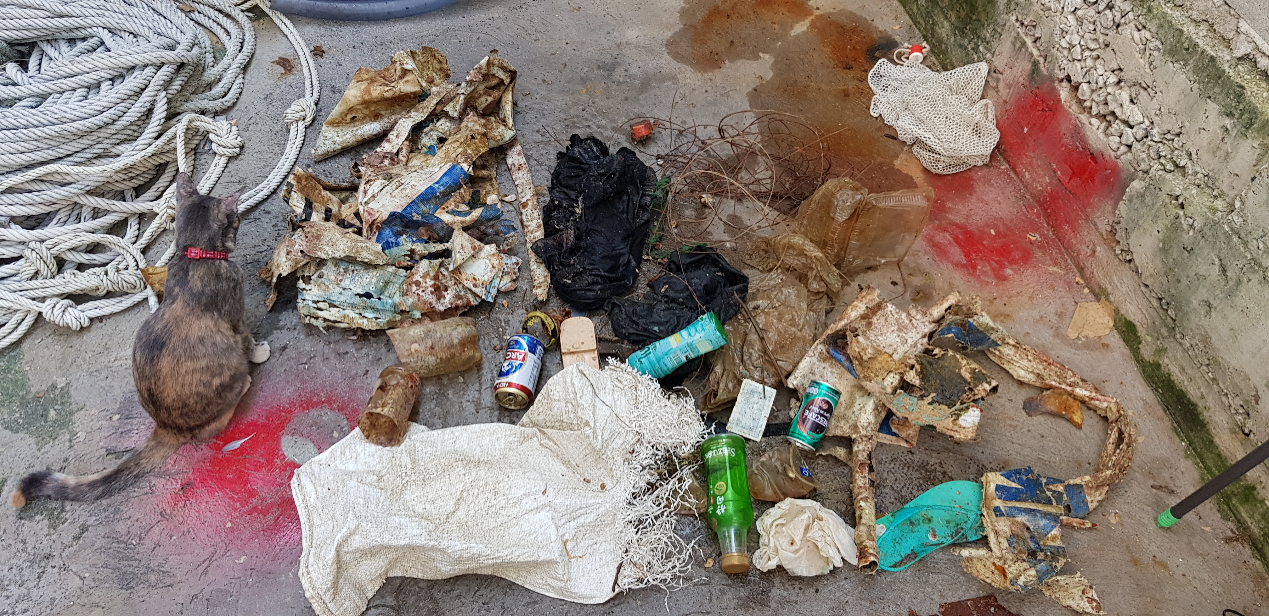
Fishermen
The crabs lived in the nets and were released
Piece of carbon fibre sheeting from a boat, about 7 kgs
Calm, sunny
Davy Jones Locker
Gregory Fresquet
1
1
11
9
27
4
11.20
58
12.00
3.00
2
measured
900.00
1
1
Fishing net
fishing line
plastic bottles.
On
kilograms
I have debris data to report
3
7
Smooth (wavelets) for waves 0.1 - 0.5 meter high
baby crabs
Dead
parrot fish
crabs
Released Unharmed
10
1
none
0
0
0
3
m2
0
meters
coral reef
0
1
3
1
2
1
10
Thailand
State\Province
Surat Thani
City
Koh Tao
Map Help


Dive Location

If you know your survey site coordinates, enter them manually in decimal degrees using WGS84 Map Datum. Use the minus sign for latitudes south of the equator and longitudes west of the Prime Meridian to 180 degrees.

If you do not know your survey site coordinates, click the “Map Location” tab to use the map to zoom into your survey site and drop the pin on the map to fall within your survey dive site in the water (not on land or the beach). Ensure you zoom in as much as possible to ensure data accuracy.

Entangled Help


Use the vertical tabs below to record any entangled animals you found of each type.

tamblli beach

sand

10.287249266768, 124.00580965339

good
skuldive center
sangwon lee
6
2
5
8
20.00
50
10.00
5.00
estimated
1
2
500.00
On
kilograms
I have debris data to report
Calm (glassy to rippled) for waves 0 – 0.1 meter high m2
meters
coral reef
1
8
7
Philippines
State\Province
cebu
City
lapulapucity
Map Help


Dive Location

If you know your survey site coordinates, enter them manually in decimal degrees using WGS84 Map Datum. Use the minus sign for latitudes south of the equator and longitudes west of the Prime Meridian to 180 degrees.

If you do not know your survey site coordinates, click the “Map Location” tab to use the map to zoom into your survey site and drop the pin on the map to fall within your survey dive site in the water (not on land or the beach). Ensure you zoom in as much as possible to ensure data accuracy.

Entangled Help


Use the vertical tabs below to record any entangled animals you found of each type.

Sea Horse Sanctuary

1
sand
6
1

12.900649558754, 100.78101172981

flipflop
Sunny with no rain.
Real Divers
James Easingwood
1
2
1
1
5
4
2.00
40
16.00
8.00
estimated
100.00
plastic bags-many in area. given from 7/11 with everything
plastic bottles- many on bottom
fishing line- area is over fished. no one stopping fishing on the reef
On
kilograms
I have debris data to report
Smooth (wavelets) for waves 0.1 - 0.5 meter high
2
1
1
m2
meters
other
2
2
Thailand
State\Province
Chonburi
City
Pattaya
Map Help


Dive Location

If you know your survey site coordinates, enter them manually in decimal degrees using WGS84 Map Datum. Use the minus sign for latitudes south of the equator and longitudes west of the Prime Meridian to 180 degrees.

If you do not know your survey site coordinates, click the “Map Location” tab to use the map to zoom into your survey site and drop the pin on the map to fall within your survey dive site in the water (not on land or the beach). Ensure you zoom in as much as possible to ensure data accuracy.

Entangled Help


Use the vertical tabs below to record any entangled animals you found of each type.

Ecosystem Other
Artificial cement block reef

ADS481 - Laplight

0
0
0

11.3443058, 124.1076441

0
0
0
sand
0
8
0
0
0
Training site for courses
No
Night dive adventure
Plastic
Good
0
0
0
0
0
0
0
0
0
0
0
0
0
0
0
0
0
0
0
0
Devocean divers
Walter
0
0
0
0
0
0
0
0
0
0
0
0
0
0
2
0
0
0
0
3
0
0
0
0
1
0
0
0
0
0
0
0
0
0
1.00
60
15.00
3.00
0
estimated
0
0
27574.70
0
0
0
0
0
Fishing line
Plastic
Diapers
0
On
kilograms
0
I have debris data to report
0
0
0
Calm (glassy to rippled) for waves 0 – 0.1 meter high
0
0
0
Coca Cola can
Anemone Fish
Crab
Released Unharmed
1
2
na
0
0
0
0
m2
0
0
meters
coral reef
0
0
0
0
0
0
0
0
0
0
0
0
0
0
0
0
2
0
0
0
0
0
0
1
0
0
0
0
Philippines
State\Province
Cebu
City
Malapascua
Map Help


Dive Location

If you know your survey site coordinates, enter them manually in decimal degrees using WGS84 Map Datum. Use the minus sign for latitudes south of the equator and longitudes west of the Prime Meridian to 180 degrees.

If you do not know your survey site coordinates, click the “Map Location” tab to use the map to zoom into your survey site and drop the pin on the map to fall within your survey dive site in the water (not on land or the beach). Ensure you zoom in as much as possible to ensure data accuracy.

Entangled Help


Use the vertical tabs below to record any entangled animals you found of each type.

ADS120 - Praia Vermelha Red Beach

73

-22.955263618689, -43.164148628712

1
sand
17
23
nublado com chuva e vento leste forte
Projeto Verde Mar
Caio Salles
6
1
1
2
1
10
1
1
9.58
60
9.00
2.00
2
measured
116
5500.00
1
1
fishing acessories
plastic bags
2
On
kilograms
I have debris data to report
3
Slight for waves 0.5 -1.25 meter high
Injured
baiacu
1
hook
1
m2
meters
rocky reef
1
1
1
2
3
2
Brazil
State\Province
RJ
City
Rio de Janeiro
Map Help


Dive Location

If you know your survey site coordinates, enter them manually in decimal degrees using WGS84 Map Datum. Use the minus sign for latitudes south of the equator and longitudes west of the Prime Meridian to 180 degrees.

If you do not know your survey site coordinates, click the “Map Location” tab to use the map to zoom into your survey site and drop the pin on the map to fall within your survey dive site in the water (not on land or the beach). Ensure you zoom in as much as possible to ensure data accuracy.

Entangled Help


Use the vertical tabs below to record any entangled animals you found of each type.

ADS116 - Tunnelen

67.234674, 14.604692

8
rock
6
1
fishing rod piece
Saltstraumen DykkeCamp
Fredric Ihrsen
1
1.80
56
28.00
3.00
measured
29
4500.00
On
kilograms
I have debris data to report
Smooth (wavelets) for waves 0.1 - 0.5 meter high m2
meters
kelp
Norway
Map Help


Dive Location

If you know your survey site coordinates, enter them manually in decimal degrees using WGS84 Map Datum. Use the minus sign for latitudes south of the equator and longitudes west of the Prime Meridian to 180 degrees.

If you do not know your survey site coordinates, click the “Map Location” tab to use the map to zoom into your survey site and drop the pin on the map to fall within your survey dive site in the water (not on land or the beach). Ensure you zoom in as much as possible to ensure data accuracy.

Entangled Help


Use the vertical tabs below to record any entangled animals you found of each type.

Ersvika

67.282847, 14.729083

10
rock
2
8
Saltstraumen DykkeCamp
Fredric Ihrsen
1
0.50
50
18.00
3.00
measured
8
2000.00
On
kilograms
I have debris data to report
Calm (glassy to rippled) for waves 0 – 0.1 meter high m2
meters
kelp
Norway
Map Help


Dive Location

If you know your survey site coordinates, enter them manually in decimal degrees using WGS84 Map Datum. Use the minus sign for latitudes south of the equator and longitudes west of the Prime Meridian to 180 degrees.

If you do not know your survey site coordinates, click the “Map Location” tab to use the map to zoom into your survey site and drop the pin on the map to fall within your survey dive site in the water (not on land or the beach). Ensure you zoom in as much as possible to ensure data accuracy.

Entangled Help


Use the vertical tabs below to record any entangled animals you found of each type.

ADS394 - Sirens

0
0
0

35.949264083388, 14.404710174877

0
0
0
rock
0
2
0
0
0
Windy
0
0
0
0
0
0
0
0
0
0
0
0
0
0
0
0
0
0
0
0
Buddies Dive Cove
Rachel E. Watts
0
0
0
0
0
0
0
0
0
0
0
0
0
0
0
0
0
0
0
4
0
0
0
0
1
0
0
2
0
0
0
0
0
0
2.00
41
6.00
0.50
0
estimated
0
0
2611.06
0
0
0
0
0
Plastic bottles
0
On
kilograms
0
I have debris data to report
0
0
0
Smooth (wavelets) for waves 0.1 - 0.5 meter high
0
0
0
0
0
0
0
m2
0
0
meters
seagrass
0
0
0
0
0
0
0
0
0
0
0
0
0
0
0
0
0
0
0
0
0
0
0
0
0
0
0
0
Malta
Map Help


Dive Location

If you know your survey site coordinates, enter them manually in decimal degrees using WGS84 Map Datum. Use the minus sign for latitudes south of the equator and longitudes west of the Prime Meridian to 180 degrees.

If you do not know your survey site coordinates, click the “Map Location” tab to use the map to zoom into your survey site and drop the pin on the map to fall within your survey dive site in the water (not on land or the beach). Ensure you zoom in as much as possible to ensure data accuracy.

Entangled Help


Use the vertical tabs below to record any entangled animals you found of each type.

Twins

1
1
sand
9

10.118497874152, 99.811174085122

Calm
Master Divers
Hayley
4
0.20
58
12.00
5.00
1
estimated
30.00
On
kilograms
I have debris data to report
Smooth (wavelets) for waves 0.1 - 0.5 meter high m2
1
meters
coral reef
Thailand
State\Province
Surat Thani
City
Koh Tao
Map Help


Dive Location

If you know your survey site coordinates, enter them manually in decimal degrees using WGS84 Map Datum. Use the minus sign for latitudes south of the equator and longitudes west of the Prime Meridian to 180 degrees.

If you do not know your survey site coordinates, click the “Map Location” tab to use the map to zoom into your survey site and drop the pin on the map to fall within your survey dive site in the water (not on land or the beach). Ensure you zoom in as much as possible to ensure data accuracy.

Entangled Help


Use the vertical tabs below to record any entangled animals you found of each type.

Bare Island, Sydney, Australia

4
2
9
sand
1
6

-33.991211024376, 151.23172957808

Kite & Mobile Phone
Sunny, small swell.
1
1
1
1
1
1
1
Screw Driver
Golf Ball
Cable Tie
Sunglasses
Anchor
Lobster Pot
Kite
Dive Centre Bondi
Emma Taylor
1
3
1
1
20
1
3
1
27.10
60
13.00
1.90
2
measured
7
660.42
Fishing line and hooks
On
kilograms
I have debris data to report
10
Smooth (wavelets) for waves 0.1 - 0.5 meter high m2
1
meters
kelp
4
1
2
2
1
309
Australia
State\Province
NSW
City
Sydney
Map Help


Dive Location

If you know your survey site coordinates, enter them manually in decimal degrees using WGS84 Map Datum. Use the minus sign for latitudes south of the equator and longitudes west of the Prime Meridian to 180 degrees.

If you do not know your survey site coordinates, click the “Map Location” tab to use the map to zoom into your survey site and drop the pin on the map to fall within your survey dive site in the water (not on land or the beach). Ensure you zoom in as much as possible to ensure data accuracy.

Entangled Help


Use the vertical tabs below to record any entangled animals you found of each type.

Subscribe to