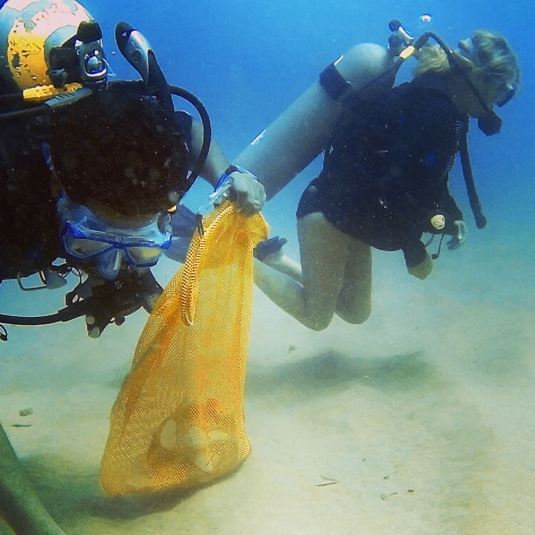
finally removed a large netting we have been working on for a few week. This is an area where a lot of divers visit so we have always been careful not to touch the net in case of spoiling the viz for others, but we had the site to ourselves and discovered the net was a lot larger than expected.
Cds
Calm
3
CD
Blue Season Bali
Samuel Norton
1
2
8
3
1
1
8
2
5
67.00
45
15.00
12.00
42
measured
45
63.45
Fishing Nets
Fishing Line
Sinkers
On
kilograms
I have debris data to report
5
Calm (glassy to rippled) for waves 0 – 0.1 meter high
3
29
9
m2
2
meters
coral reef
1
4
3
Indonesia
Map Help
Dive Location
If you know your survey site coordinates, enter them manually in decimal degrees using WGS84 Map Datum. Use the minus sign for latitudes south of the equator and longitudes west of the Prime Meridian to 180 degrees.
If you do not know your survey site coordinates, click the “Map Location” tab to use the map to zoom into your survey site and drop the pin on the map to fall within your survey dive site in the water (not on land or the beach). Ensure you zoom in as much as possible to ensure data accuracy.
Entangled Help
Use the vertical tabs below to record any entangled animals you found of each type.
Calm (glassy to rippled) for waves 0 – 0.1 meter high
m2
4
meters
rocky reef
2
1
Language
English
Malaysia
State\Province
Sabah
City
Mabul
Map Help
Dive Location
If you know your survey site coordinates, enter them manually in decimal degrees using WGS84 Map Datum. Use the minus sign for latitudes south of the equator and longitudes west of the Prime Meridian to 180 degrees.
If you do not know your survey site coordinates, click the “Map Location” tab to use the map to zoom into your survey site and drop the pin on the map to fall within your survey dive site in the water (not on land or the beach). Ensure you zoom in as much as possible to ensure data accuracy.
Entangled Help
Use the vertical tabs below to record any entangled animals you found of each type.
We did not just dive but cleaned the surrounding park area
Rain, was in to the water, dumped by informal squatters in the region
Informal settlers created are big mess across the road from the dive site this was reported to the council consequently the area has been cleared and restored clean! I believe they dump lots of debris into the water.
Trolley
Great
0
0
0
0
0
0
0
0
0
0
0
0
0
0
0
0
0
0
0
0
Dive Den Scuba
Pierre Brits
1
2
2
18
0
26
0
6
1
0
0
0
0
0
0
0
3
41
0
12
0
0
0
0
30
0
0
8
12
0
6
0
0
0
60.00
42
10.00
6.00
4
estimated
0
3
1000.00
0
1
0
0
0
Bicycle parts
Chair
wheels
0
On
kilograms
0
I have debris data to report
4
0
0
Smooth (wavelets) for waves 0.1 - 0.5 meter high
0
0
0
0
0
0
0
0
m2
0
0
meters
rocky reef
2
0
0
0
0
2
0
0
1
0
0
0
0
3
0
7
16
0
0
2
0
0
0
0
1
3
2
0
Language
English
Australia
State\Province
NSW
City
Tweed Heads
Map Help
Dive Location
If you know your survey site coordinates, enter them manually in decimal degrees using WGS84 Map Datum. Use the minus sign for latitudes south of the equator and longitudes west of the Prime Meridian to 180 degrees.
If you do not know your survey site coordinates, click the “Map Location” tab to use the map to zoom into your survey site and drop the pin on the map to fall within your survey dive site in the water (not on land or the beach). Ensure you zoom in as much as possible to ensure data accuracy.
Entangled Help
Use the vertical tabs below to record any entangled animals you found of each type.
If you know your survey site coordinates, enter them manually in decimal degrees using WGS84 Map Datum. Use the minus sign for latitudes south of the equator and longitudes west of the Prime Meridian to 180 degrees.
If you do not know your survey site coordinates, click the “Map Location” tab to use the map to zoom into your survey site and drop the pin on the map to fall within your survey dive site in the water (not on land or the beach). Ensure you zoom in as much as possible to ensure data accuracy.
Entangled Help
Use the vertical tabs below to record any entangled animals you found of each type.
Calm (glassy to rippled) for waves 0 – 0.1 meter high
the whole fishing net
Dead
Fish
2 Crabs and 3 Conch
Injured
5
8
the whole fishing net
m2
meters
other
Language
English
Sri Lanka
City
Trincomalee
Map Help
Dive Location
If you know your survey site coordinates, enter them manually in decimal degrees using WGS84 Map Datum. Use the minus sign for latitudes south of the equator and longitudes west of the Prime Meridian to 180 degrees.
If you do not know your survey site coordinates, click the “Map Location” tab to use the map to zoom into your survey site and drop the pin on the map to fall within your survey dive site in the water (not on land or the beach). Ensure you zoom in as much as possible to ensure data accuracy.
Entangled Help
Use the vertical tabs below to record any entangled animals you found of each type.
Calm (glassy to rippled) for waves 0 – 0.1 meter high
m2
meters
rocky reef
Language
English
China
City
Shimei Bay, Wanning
Map Help
Dive Location
If you know your survey site coordinates, enter them manually in decimal degrees using WGS84 Map Datum. Use the minus sign for latitudes south of the equator and longitudes west of the Prime Meridian to 180 degrees.
If you do not know your survey site coordinates, click the “Map Location” tab to use the map to zoom into your survey site and drop the pin on the map to fall within your survey dive site in the water (not on land or the beach). Ensure you zoom in as much as possible to ensure data accuracy.
Entangled Help
Use the vertical tabs below to record any entangled animals you found of each type.
Calm (glassy to rippled) for waves 0 – 0.1 meter high
m2
meters
coral reef
1
Language
English
China
City
Shinmei Bay, Wanning
Map Help
Dive Location
If you know your survey site coordinates, enter them manually in decimal degrees using WGS84 Map Datum. Use the minus sign for latitudes south of the equator and longitudes west of the Prime Meridian to 180 degrees.
If you do not know your survey site coordinates, click the “Map Location” tab to use the map to zoom into your survey site and drop the pin on the map to fall within your survey dive site in the water (not on land or the beach). Ensure you zoom in as much as possible to ensure data accuracy.
Entangled Help
Use the vertical tabs below to record any entangled animals you found of each type.
Calm (glassy to rippled) for waves 0 – 0.1 meter high
6
10
8
m2
10
3
meters
other
5
10
Language
English
China
Map Help
Dive Location
If you know your survey site coordinates, enter them manually in decimal degrees using WGS84 Map Datum. Use the minus sign for latitudes south of the equator and longitudes west of the Prime Meridian to 180 degrees.
If you do not know your survey site coordinates, click the “Map Location” tab to use the map to zoom into your survey site and drop the pin on the map to fall within your survey dive site in the water (not on land or the beach). Ensure you zoom in as much as possible to ensure data accuracy.
Entangled Help
Use the vertical tabs below to record any entangled animals you found of each type.