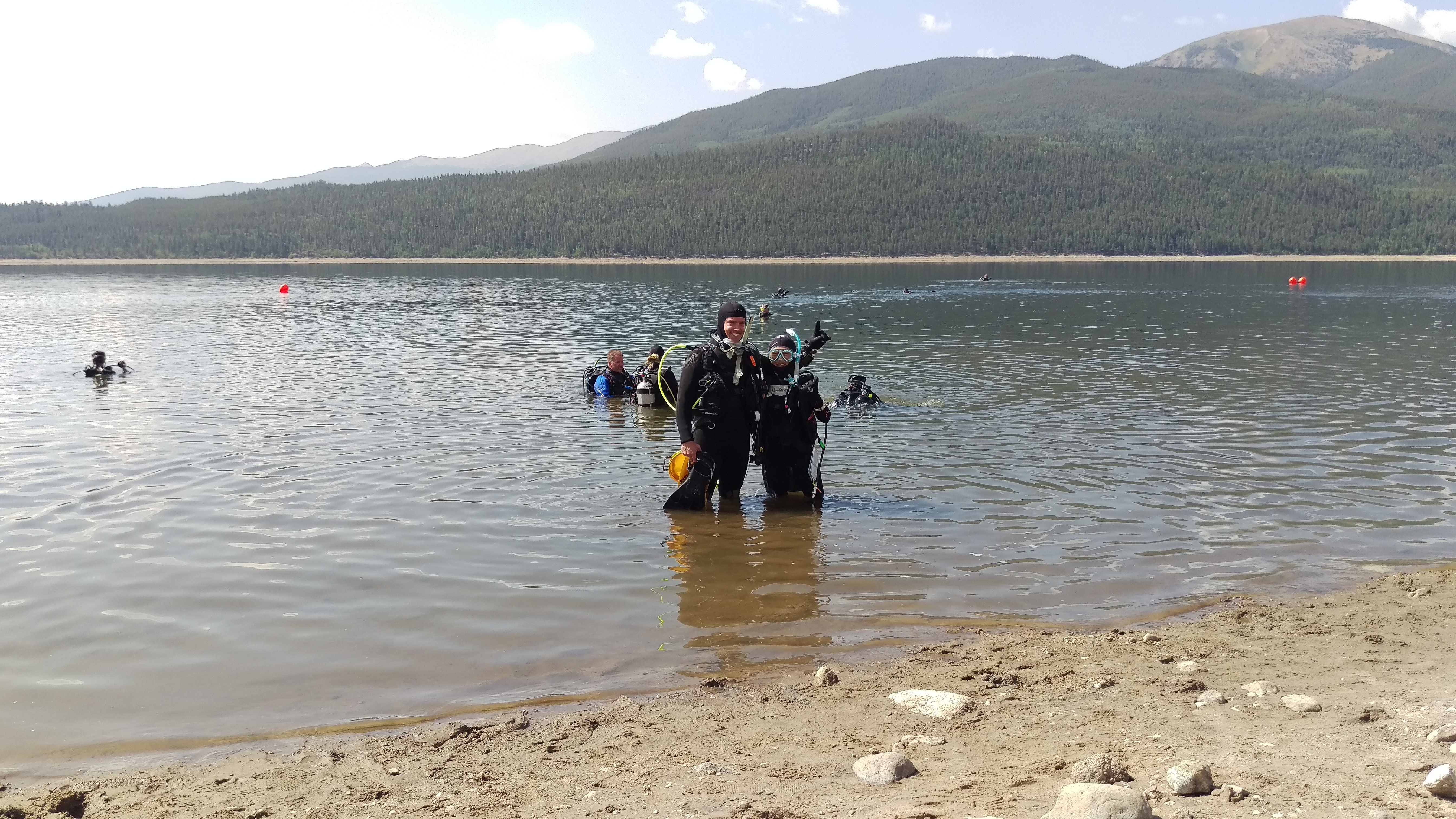
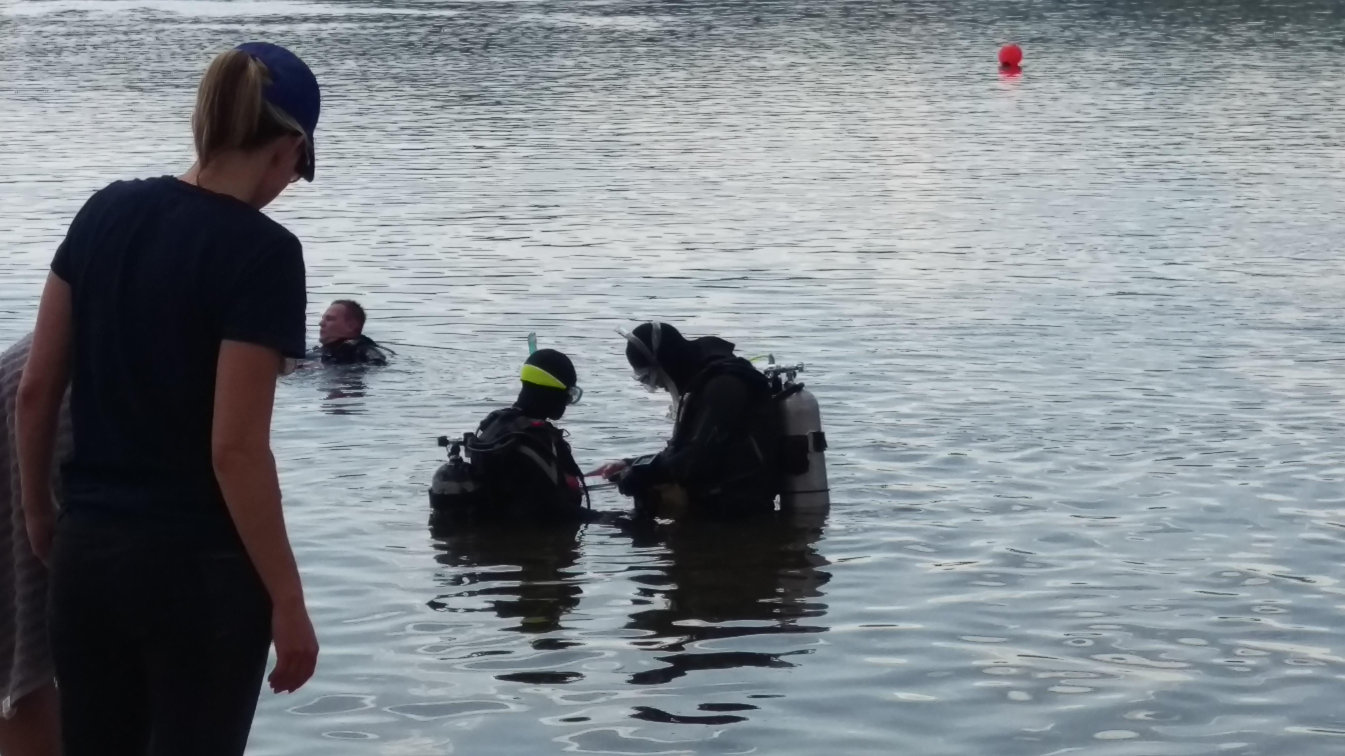
Menu

Twin Lakes

silt
1

39.090120853589, -106.32531132492

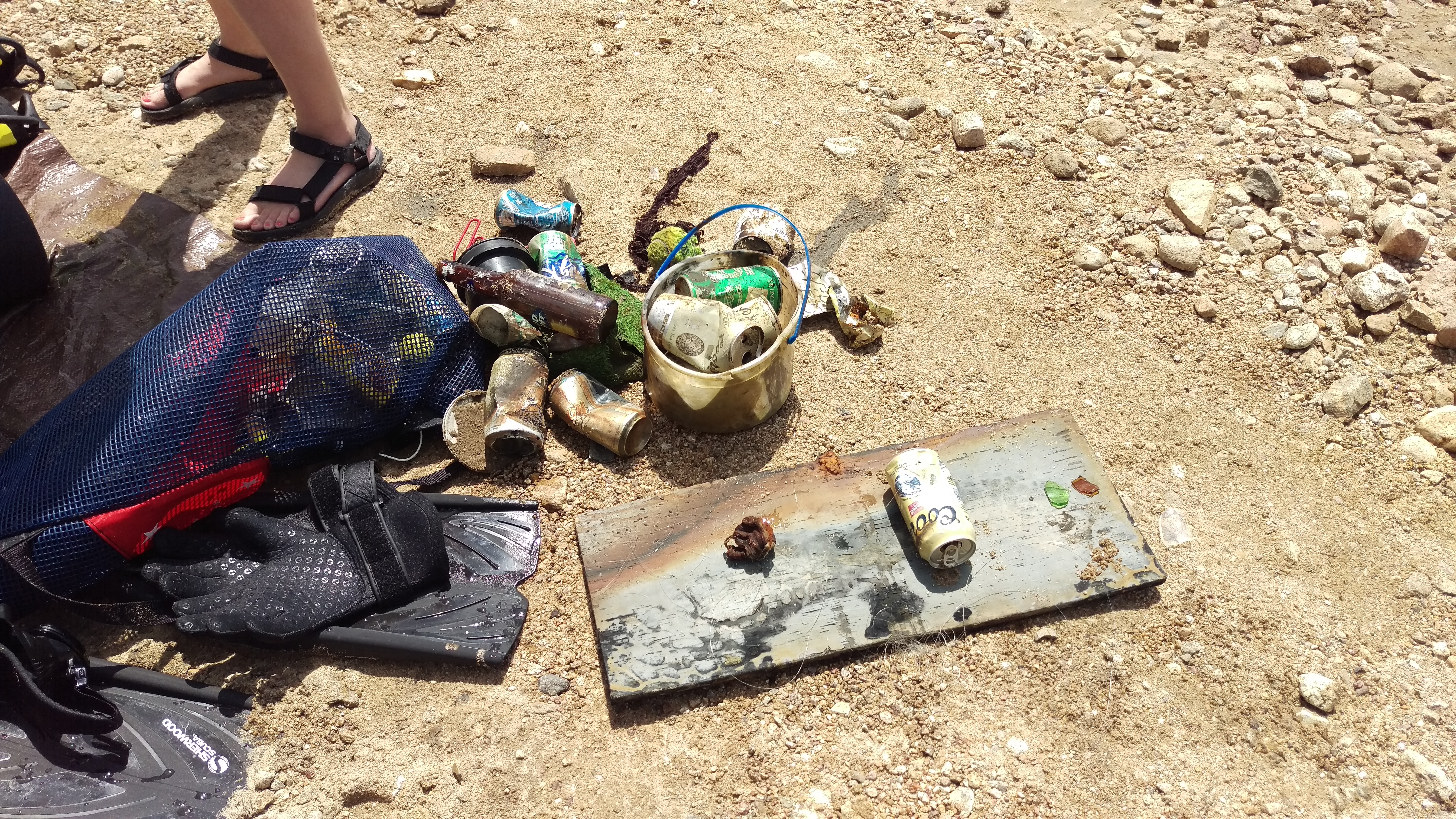
Beer cans "Coors Light" with pop tops & shooter tops, circa 1975.
Normal
Kaleb Matlack
1
1
1
42
20.00
90
30.00
0.00
estimated
1
22000.00
On
pounds
I have debris data to report
2
Calm (glassy to rippled) for waves 0 – 0.1 meter high
0
ft2
feet
other
3
12
United States
State\Province
CO
City
Twin Lakes
Map Help


Dive Location

If you know your survey site coordinates, enter them manually in decimal degrees using WGS84 Map Datum. Use the minus sign for latitudes south of the equator and longitudes west of the Prime Meridian to 180 degrees.

If you do not know your survey site coordinates, click the “Map Location” tab to use the map to zoom into your survey site and drop the pin on the map to fall within your survey dive site in the water (not on land or the beach). Ensure you zoom in as much as possible to ensure data accuracy.

Entangled Help


Use the vertical tabs below to record any entangled animals you found of each type.

Ecosystem Other
Mountain Lake - upstream

Labyrinth

0
0
0
0

24.48013, -80.41118

1
0
0
coral
0
2
0
21
0
Hurricane Irma
Bandaid
Moderate wind
1
2
Bandaid
Anchor
Key Dives/FKNMS
Cortney Benson
0
0
0
1
0
0
0
0
0
0
0
0
0
0
0
0
0
0
0
21
0
0
0
0
0
0
0
0
0
0
0
0
0
0
0
4
80.00
50
50.00
40.00
42
measured
0
3
0
2
150.00
0
0
0
0
0
Anchor lines
Lobster lines
Fishing line
0
On
pounds
0
I have debris data to report
0
0
0
Smooth (wavelets) for waves 0.1 - 0.5 meter high
0
0
0
0
0
0
0
m2
0
0
feet
coral reef
0
0
0
0
0
0
0
0
1
0
0
0
0
0
0
0
0
0
0
0
0
0
0
0
0
0
0
0
0
United States
State\Province
Florida
City
Islamorada
Map Help


Dive Location

If you know your survey site coordinates, enter them manually in decimal degrees using WGS84 Map Datum. Use the minus sign for latitudes south of the equator and longitudes west of the Prime Meridian to 180 degrees.

If you do not know your survey site coordinates, click the “Map Location” tab to use the map to zoom into your survey site and drop the pin on the map to fall within your survey dive site in the water (not on land or the beach). Ensure you zoom in as much as possible to ensure data accuracy.

Entangled Help


Use the vertical tabs below to record any entangled animals you found of each type.

Fossens Camping - Gullmarsfjorden

58.321482727104, 11.559505295008

silt
5
Released from being stuck, but could not remove all fishing line from legs
Calm
Oxygene Diving
Josefin Rydström
10
0.60
42
30.00
5.00
measured
5
4598.01
1
Fishing line
On
kilograms
I have debris data to report
Calm (glassy to rippled) for waves 0 – 0.1 meter high
Fishing line
Cancer pagurus
Released Unharmed
1
m2
meters
rocky reef
3
Sweden
City
Göteborg
Map Help


Dive Location

If you know your survey site coordinates, enter them manually in decimal degrees using WGS84 Map Datum. Use the minus sign for latitudes south of the equator and longitudes west of the Prime Meridian to 180 degrees.

If you do not know your survey site coordinates, click the “Map Location” tab to use the map to zoom into your survey site and drop the pin on the map to fall within your survey dive site in the water (not on land or the beach). Ensure you zoom in as much as possible to ensure data accuracy.

Entangled Help


Use the vertical tabs below to record any entangled animals you found of each type.

Secret Bay

0
0
0

13.686108486322, 120.89690670098

0
0
0
sand
0
7
0
0
0
None
Monsoon
None
None
Southwest Monsoon
0
0
0
0
0
0
0
0
0
0
0
0
0
0
0
0
0
0
0
0
divers.ph
Suratwadee Ngamsong
0
0
0
0
0
0
0
0
0
0
0
0
0
0
0
0
0
2
0
1
0
0
0
0
0
0
0
0
0
0
0
0
0
0
0.20
30
12.00
3.00
0
estimated
0
0
30.00
0
0
0
0
0
Plastics
None
None
0
On
kilograms
0
I have debris data to report
0
0
0
Slight for waves 0.5 -1.25 meter high
0
0
0
0
0
0
0
m2
0
0
meters
other
0
0
0
0
0
0
0
0
0
0
0
0
0
0
0
0
0
0
0
0
0
0
0
0
0
0
0
0
Philippines
State\Province
Batangas
City
Mabini
Map Help


Dive Location

If you know your survey site coordinates, enter them manually in decimal degrees using WGS84 Map Datum. Use the minus sign for latitudes south of the equator and longitudes west of the Prime Meridian to 180 degrees.

If you do not know your survey site coordinates, click the “Map Location” tab to use the map to zoom into your survey site and drop the pin on the map to fall within your survey dive site in the water (not on land or the beach). Ensure you zoom in as much as possible to ensure data accuracy.

Entangled Help


Use the vertical tabs below to record any entangled animals you found of each type.

Looe Key SPA East and Adjacent Area

24.324925, -81.240068

1
coral
4
Hurricane Irma, 2017
10 stone crabs were also released unharmed.
Concrete Bollard
Partly sunny
1
Concrete Bollard
DiveN2Life/Looe Key Dive Center/FKNMS/
Kama Cannon
1
1
16
2
9
1
1500.00
360
80.00
30.00
measured
19
1
0.20
Derelict traps
Ropes and Buoys
Pieces of wood from traps
On
pounds
I have debris data to report
1
Smooth (wavelets) for waves 0.1 - 0.5 meter high
22
derelict traps
Lobster
Released Unharmed
66
ft2
1800
feet
coral reef
3
6
1
1
United States
State\Province
Florida
City
Big Torch Key
Map Help


Dive Location

If you know your survey site coordinates, enter them manually in decimal degrees using WGS84 Map Datum. Use the minus sign for latitudes south of the equator and longitudes west of the Prime Meridian to 180 degrees.

If you do not know your survey site coordinates, click the “Map Location” tab to use the map to zoom into your survey site and drop the pin on the map to fall within your survey dive site in the water (not on land or the beach). Ensure you zoom in as much as possible to ensure data accuracy.

Entangled Help


Use the vertical tabs below to record any entangled animals you found of each type.

Seaward Looe Key SPA SW

1
coral
1
2

24.600279825655, -81.343376899045

Hurricane Irma, 2017
Metal construction grate
Sunny and clear
1
Metal Construction Grate
DiveN2Life/Looe Key Dive Center/FKNMS/
Kama Cannon
16
6
490.00
120
55.00
30.00
2
measured
5
4
0.10
Derelict traps
Rope and Buoys
Pieces of wood from traps
On
pounds
I have debris data to report
Smooth (wavelets) for waves 0.1 - 0.5 meter high
29
ft2
9
feet
coral reef
2
United States
State\Province
FLorida
City
Big Torch Key
Map Help


Dive Location

If you know your survey site coordinates, enter them manually in decimal degrees using WGS84 Map Datum. Use the minus sign for latitudes south of the equator and longitudes west of the Prime Meridian to 180 degrees.

If you do not know your survey site coordinates, click the “Map Location” tab to use the map to zoom into your survey site and drop the pin on the map to fall within your survey dive site in the water (not on land or the beach). Ensure you zoom in as much as possible to ensure data accuracy.

Entangled Help


Use the vertical tabs below to record any entangled animals you found of each type.

ADS88 - Dive Bus House Reef

0
50
0
0

12.090354, -68.905073

0
0
0
coral
0
0
0
100
0
Cd's and phone
Windy
The Dive Bus
Bor
0
2
0
14
0
0
0
0
0
0
0
0
0
0
0
0
0
0
5
6
0
0
0
0
0
0
5
0
0
0
0
0
0
0
0
0
25.00
60
21.00
2.00
0
measured
0
0
0
57
4206.00
0
0
0
4
0
Phishing line
Sinkers
0
On
pounds
0
I have debris data to report
12
0
0
Calm (glassy to rippled) for waves 0 – 0.1 meter high
0
0
0
0
0
0
0
m2
0
0
meters
coral reef
0
0
0
0
0
0
0
0
0
24
13
0
0
0
0
0
10
0
0
0
0
0
18
0
0
0
0
0
0
Netherlands Antilles
State\Province
Curacao
City
Willemstad
Map Help


Dive Location

If you know your survey site coordinates, enter them manually in decimal degrees using WGS84 Map Datum. Use the minus sign for latitudes south of the equator and longitudes west of the Prime Meridian to 180 degrees.

If you do not know your survey site coordinates, click the “Map Location” tab to use the map to zoom into your survey site and drop the pin on the map to fall within your survey dive site in the water (not on land or the beach). Ensure you zoom in as much as possible to ensure data accuracy.

Entangled Help


Use the vertical tabs below to record any entangled animals you found of each type.

Cedar Point

4
14
1
1
2
sand
2

44.811476276629, -80.118462890814

We were collecting adjacent to the Christian Island ferry harbour.
Toy gun
Fair, sunny and light winds.
1 toy gun
Georgian Bay Divers
Lee Munson
4
1
1
5
2
0
13
1
1
10.00
66
15.00
5.00
estimated
50.00
Cans
Plastic bottles
On
pounds
I have debris data to report
1
Calm (glassy to rippled) for waves 0 – 0.1 meter high m2
meters
other
1
2
41
Canada
State\Province
Ontario
City
Tiny
Map Help


Dive Location

If you know your survey site coordinates, enter them manually in decimal degrees using WGS84 Map Datum. Use the minus sign for latitudes south of the equator and longitudes west of the Prime Meridian to 180 degrees.

If you do not know your survey site coordinates, click the “Map Location” tab to use the map to zoom into your survey site and drop the pin on the map to fall within your survey dive site in the water (not on land or the beach). Ensure you zoom in as much as possible to ensure data accuracy.

Entangled Help


Use the vertical tabs below to record any entangled animals you found of each type.

Ecosystem Other
Sandy bottom

ADS240 - Ricardo Wreck

4

33.81666, 11.14999

sand
26
Very nice ! sun, sun, and sun !
Archimede Diving Center
Abdelaziz Aissine
4
2
11
18.60
21
27.00
24.00
2
measured
56
220.00
On
kilograms
I have debris data to report
Smooth (wavelets) for waves 0.1 - 0.5 meter high m2
meters
seagrass
1
1
1
2
Tunisia
State\Province
Djerba Island
City
Midoun
Map Help


Dive Location

If you know your survey site coordinates, enter them manually in decimal degrees using WGS84 Map Datum. Use the minus sign for latitudes south of the equator and longitudes west of the Prime Meridian to 180 degrees.

If you do not know your survey site coordinates, click the “Map Location” tab to use the map to zoom into your survey site and drop the pin on the map to fall within your survey dive site in the water (not on land or the beach). Ensure you zoom in as much as possible to ensure data accuracy.

Entangled Help


Use the vertical tabs below to record any entangled animals you found of each type.

ADS241 - Ras Taguermess Rocks

1

33.83473, 11.07443

rock
21
Good !
Archimede Diving Center
Abdelaziz Aissine
5
1
4
2.90
42
12.00
9.00
1
measured
36
600.00
Fishing lines
Fishing sinkers, lures and hooks
Fishing nets and pieces of nets
On
kilograms
I have debris data to report
Calm (glassy to rippled) for waves 0 – 0.1 meter high m2
meters
seagrass
Tunisia
State\Province
Djerba Island
City
Midoun
Map Help


Dive Location

If you know your survey site coordinates, enter them manually in decimal degrees using WGS84 Map Datum. Use the minus sign for latitudes south of the equator and longitudes west of the Prime Meridian to 180 degrees.

If you do not know your survey site coordinates, click the “Map Location” tab to use the map to zoom into your survey site and drop the pin on the map to fall within your survey dive site in the water (not on land or the beach). Ensure you zoom in as much as possible to ensure data accuracy.

Entangled Help


Use the vertical tabs below to record any entangled animals you found of each type.

Subscribe to