Menu

Pink rocks

0
0
0
0

-35.855107780598, 150.1856073057

0
0
0
sand
0
0
0
0
0
Dive site was free of debris, didn’t see anything unusual
No
No visible marks of collision or attach
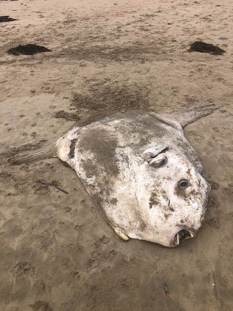
A dead sunfish !
No rain, standard winds and swell
Drawn2Water
Mick
0
0
0
0
0
0
0
0
0
0
0
0
0
0
0
0
0
0
0
12
0
0
0
0
0
0
0
0
0
0
0
0
0
0
0
0
0.00
30
4.00
1.00
0
measured
0
0
5480.56
0
0
0
0
0
Washed up sun fish
Plastic bag
Nil
0
On
kilograms
0
Our Survey Site was free of debris
0
0
0
Calm (glassy to rippled) for waves 0 – 0.1 meter high
0
0
0
0
0
0
0
m2
0
0
meters
other
0
0
0
0
0
0
0
0
0
0
0
0
0
0
0
0
0
0
0
0
0
0
0
0
0
0
0
0
0
Australia
State\Province
Nsw
City
Broulee
Map Help


Dive Location

If you know your survey site coordinates, enter them manually in decimal degrees using WGS84 Map Datum. Use the minus sign for latitudes south of the equator and longitudes west of the Prime Meridian to 180 degrees.

If you do not know your survey site coordinates, click the “Map Location” tab to use the map to zoom into your survey site and drop the pin on the map to fall within your survey dive site in the water (not on land or the beach). Ensure you zoom in as much as possible to ensure data accuracy.

Entangled Help


Use the vertical tabs below to record any entangled animals you found of each type.

Ecosystem Other
Sand

Kahe Beach Park

0
1
0
0

21.356149906083, -158.13113794706

1
0
0
sand
0
0
0
6
0
Beach camping, shore fishing
Whole spool of line
Clear
HMAR
Jace Reinken
0
0
0
0
0
0
0
0
0
0
0
0
0
0
0
0
0
0
0
5
0
0
0
0
0
0
0
0
0
0
0
0
0
0
0
0
23.00
60
11.00
4.00
0
estimated
0
14
3454.89
0
0
0
0
0
Fishing line
Sinkers
Snorkel equipment
0
On
pounds
0
I have debris data to report
0
0
0
Slight for waves 0.5 -1.25 meter high
0
0
0
0
1
0
0
ft2
0
0
feet
coral reef
0
0
0
0
0
0
0
0
0
0
0
0
0
0
0
0
0
0
0
0
0
0
0
0
0
0
0
0
0
United States
State\Province
Hawaii
City
Honolulu
Map Help


Dive Location

If you know your survey site coordinates, enter them manually in decimal degrees using WGS84 Map Datum. Use the minus sign for latitudes south of the equator and longitudes west of the Prime Meridian to 180 degrees.

If you do not know your survey site coordinates, click the “Map Location” tab to use the map to zoom into your survey site and drop the pin on the map to fall within your survey dive site in the water (not on land or the beach). Ensure you zoom in as much as possible to ensure data accuracy.

Entangled Help


Use the vertical tabs below to record any entangled animals you found of each type.

Shelter Island

0
0
0
12

22.33110110444, 114.29345203783

0
0
0
sand
0
0
0
6
0
Windy
A Plastic Ocean Foundation
Kevin Suen
0
0
0
0
0
0
0
0
0
0
0
0
0
0
0
0
0
0
0
6
0
0
0
0
0
0
0
0
0
0
0
0
0
0
0
0
196.70
45
6.00
3.10
6
measured
0
0
1912.21
0
0
0
0
0
Fishing net
0
On
kilograms
0
I have debris data to report
0
0
0
Smooth (wavelets) for waves 0.1 - 0.5 meter high
0
0
0
0
0
0
0
m2
0
0
meters
coral reef
0
0
0
0
0
0
0
0
0
0
0
0
0
0
0
0
0
0
0
0
0
0
0
0
0
0
0
0
0
Hong Kong S.A.R., China
State\Province
Hong Kong
City
Hong Kong
Map Help


Dive Location

If you know your survey site coordinates, enter them manually in decimal degrees using WGS84 Map Datum. Use the minus sign for latitudes south of the equator and longitudes west of the Prime Meridian to 180 degrees.

If you do not know your survey site coordinates, click the “Map Location” tab to use the map to zoom into your survey site and drop the pin on the map to fall within your survey dive site in the water (not on land or the beach). Ensure you zoom in as much as possible to ensure data accuracy.

Entangled Help


Use the vertical tabs below to record any entangled animals you found of each type.

susami #832675

2
0
3
0

33.547603, 135.485352

0
0
0
sand
0
0
0
0
0
プラスチックゴミ
calm
cocomo
riho fukushima
0
0
0
0
0
0
0
0
0
0
0
0
0
0
0
0
0
0
0
3
0
0
0
0
0
0
0
0
0
0
0
0
0
0
0
0
1.00
30
12.00
7.00
0
measured
0
0
0
0
6865.00
0
0
0
0
0
ビン
プラスチック製容器
お菓子包装のビニール袋
0
On
kilograms
0
I have debris data to report
2
0
0
Calm (glassy to rippled) for waves 0 – 0.1 meter high
0
0
0
0
0
0
0
m2
0
0
meters
coral reef
0
0
0
0
0
0
0
0
0
0
0
0
0
0
0
0
0
0
0
0
0
0
0
0
0
0
0
0
0
Japan
State\Province
wakayama
City
susami
Map Help


Dive Location

If you know your survey site coordinates, enter them manually in decimal degrees using WGS84 Map Datum. Use the minus sign for latitudes south of the equator and longitudes west of the Prime Meridian to 180 degrees.

If you do not know your survey site coordinates, click the “Map Location” tab to use the map to zoom into your survey site and drop the pin on the map to fall within your survey dive site in the water (not on land or the beach). Ensure you zoom in as much as possible to ensure data accuracy.

Entangled Help


Use the vertical tabs below to record any entangled animals you found of each type.

otomi

0
0
0
0

35.539614, 135.500954

0
0
0
sand
0
0
0
0
0
台風等の自然災害
屋根の破片
calm
4
トタン屋根の残骸
cocomo
riho fukushima
0
0
0
0
0
0
0
0
0
0
0
0
0
0
0
0
0
0
0
4
0
0
0
0
0
0
0
0
0
2
0
0
0
0
0
0
1.00
40
7.00
5.00
0
measured
0
0
0
0
5573.23
0
0
0
0
0
屋根破片
0
On
kilograms
0
I have debris data to report
2
0
0
Calm (glassy to rippled) for waves 0 – 0.1 meter high
0
0
0
0
0
0
0
m2
0
0
meters
rocky reef
0
0
0
0
0
0
0
0
0
0
0
0
0
0
0
0
0
0
0
0
0
0
0
4
0
0
0
0
0
Japan
State\Province
otomi
City
takahama
Map Help


Dive Location

If you know your survey site coordinates, enter them manually in decimal degrees using WGS84 Map Datum. Use the minus sign for latitudes south of the equator and longitudes west of the Prime Meridian to 180 degrees.

If you do not know your survey site coordinates, click the “Map Location” tab to use the map to zoom into your survey site and drop the pin on the map to fall within your survey dive site in the water (not on land or the beach). Ensure you zoom in as much as possible to ensure data accuracy.

Entangled Help


Use the vertical tabs below to record any entangled animals you found of each type.

outside cold lake fuelling jetty

1
16
sand
10

54.464555362988, -110.16664570945

no
6” nail
cloudy -3c
1
3
steel bar
money coins
Dunnill’s Diving Services
Stuart Dunnill
1
4
2
2
7.10
30
17.00
5.00
measured
4
300.00
rebar
tires
On
pounds
I have debris data to report
4
Calm (glassy to rippled) for waves 0 – 0.1 meter high
1
ft2
feet
other
1
5
2
6
1
Canada
State\Province
Alberta
City
Cold Lake
Map Help


Dive Location

If you know your survey site coordinates, enter them manually in decimal degrees using WGS84 Map Datum. Use the minus sign for latitudes south of the equator and longitudes west of the Prime Meridian to 180 degrees.

If you do not know your survey site coordinates, click the “Map Location” tab to use the map to zoom into your survey site and drop the pin on the map to fall within your survey dive site in the water (not on land or the beach). Ensure you zoom in as much as possible to ensure data accuracy.

Entangled Help


Use the vertical tabs below to record any entangled animals you found of each type.

Shelter Island

0
0
0
20

22.33180045171, 114.294159862

0
0
0
sand
0
0
0
20
0
No
No
Sunny
A Plastic Ocean Foundation
Kevin Suen
0
0
0
0
0
0
0
0
0
0
0
0
0
0
0
0
0
0
0
6
0
0
0
0
0
0
0
0
20
0
0
0
0
0
0
0
200.00
45
5.00
3.10
10
measured
0
0
7287.12
0
0
0
0
0
Fishing gear
0
On
kilograms
0
I have debris data to report
0
0
0
Smooth (wavelets) for waves 0.1 - 0.5 meter high
0
0
0
0
0
0
0
m2
0
0
meters
coral reef
0
0
0
0
0
0
0
0
0
0
0
0
0
0
0
0
0
0
0
0
0
0
0
0
0
0
0
0
0
Hong Kong S.A.R., China
State\Province
Hong Kong
City
Hong Kong
Map Help


Dive Location

If you know your survey site coordinates, enter them manually in decimal degrees using WGS84 Map Datum. Use the minus sign for latitudes south of the equator and longitudes west of the Prime Meridian to 180 degrees.

If you do not know your survey site coordinates, click the “Map Location” tab to use the map to zoom into your survey site and drop the pin on the map to fall within your survey dive site in the water (not on land or the beach). Ensure you zoom in as much as possible to ensure data accuracy.

Entangled Help


Use the vertical tabs below to record any entangled animals you found of each type.

North Point Reef Rottness Island

sand

-31.9888889, 115.5

Calm, mild wind and mild swell
Perth Scuba
Ana
1
0.00
37
17.30
-44.00
estimated
300.00
On
kilograms
Our Survey Site was free of debris
Calm (glassy to rippled) for waves 0 – 0.1 meter high m2
meters
other
Australia
State\Province
WA
City
Perth
Map Help


Dive Location

If you know your survey site coordinates, enter them manually in decimal degrees using WGS84 Map Datum. Use the minus sign for latitudes south of the equator and longitudes west of the Prime Meridian to 180 degrees.

If you do not know your survey site coordinates, click the “Map Location” tab to use the map to zoom into your survey site and drop the pin on the map to fall within your survey dive site in the water (not on land or the beach). Ensure you zoom in as much as possible to ensure data accuracy.

Entangled Help


Use the vertical tabs below to record any entangled animals you found of each type.

Ecosystem Other
Limestone reef

Dauin North

0
62
30
0

9.1876427111748, 123.26545233784

0
0
0
sand
6
45
0
0
8
Party weekend
Condom
Good
Bongo Bongo Divers
Dylan
0
1
0
28
35
0
0
2
1
19
3
0
3
2
0
0
0
15
18
8
0
0
0
8
0
0
6
0
2
11
0
0
0
1
1
0
25.00
45
3.00
1.00
2
estimated
0
0
4052.24
0
0
0
0
1
Plastic bottle
Plastic wrappers
Plastic bags
0
On
kilograms
0
I have debris data to report
0
0
0
Calm (glassy to rippled) for waves 0 – 0.1 meter high
8
0
1
0
7
0
0
m2
0
0
meters
coral reef
6
0
0
0
1
15
0
0
0
0
0
0
0
0
1
1
2
10
0
0
0
0
13
0
0
0
0
2
0
Philippines
State\Province
Negros Oriental
City
Dauin
Map Help


Dive Location

If you know your survey site coordinates, enter them manually in decimal degrees using WGS84 Map Datum. Use the minus sign for latitudes south of the equator and longitudes west of the Prime Meridian to 180 degrees.

If you do not know your survey site coordinates, click the “Map Location” tab to use the map to zoom into your survey site and drop the pin on the map to fall within your survey dive site in the water (not on land or the beach). Ensure you zoom in as much as possible to ensure data accuracy.

Entangled Help


Use the vertical tabs below to record any entangled animals you found of each type.

Tabourie island

0
0
0
0

-35.439390779037, 150.4107181056

0
0
0
sand
0
0
0
0
0
Sea urchin population is moderate
No
No smaller beach fish in close. No whiting or bream. Some health fish species out wider.
No
Medium swell, moderate variable winds
Drawn2Water
Mick
0
0
0
0
0
0
0
0
0
0
0
0
0
0
0
0
0
0
0
8
0
0
0
0
0
0
0
0
0
0
0
0
0
0
0
0
0.00
25
6.00
1.00
0
measured
0
0
7980.55
0
0
0
0
0
0
On
kilograms
0
Our Survey Site was free of debris
0
0
0
Calm (glassy to rippled) for waves 0 – 0.1 meter high
0
0
0
0
0
0
0
m2
0
0
meters
other
0
0
0
0
0
0
0
0
0
0
0
0
0
0
0
0
0
0
0
0
0
0
0
0
0
0
0
0
0
Australia
State\Province
Nsw
City
Lake Tabourie
Map Help


Dive Location

If you know your survey site coordinates, enter them manually in decimal degrees using WGS84 Map Datum. Use the minus sign for latitudes south of the equator and longitudes west of the Prime Meridian to 180 degrees.

If you do not know your survey site coordinates, click the “Map Location” tab to use the map to zoom into your survey site and drop the pin on the map to fall within your survey dive site in the water (not on land or the beach). Ensure you zoom in as much as possible to ensure data accuracy.

Entangled Help


Use the vertical tabs below to record any entangled animals you found of each type.

Ecosystem Other
Other
Subscribe to