Menu

Avalon Dive Park

sand

33.349261204259, -118.32503914833

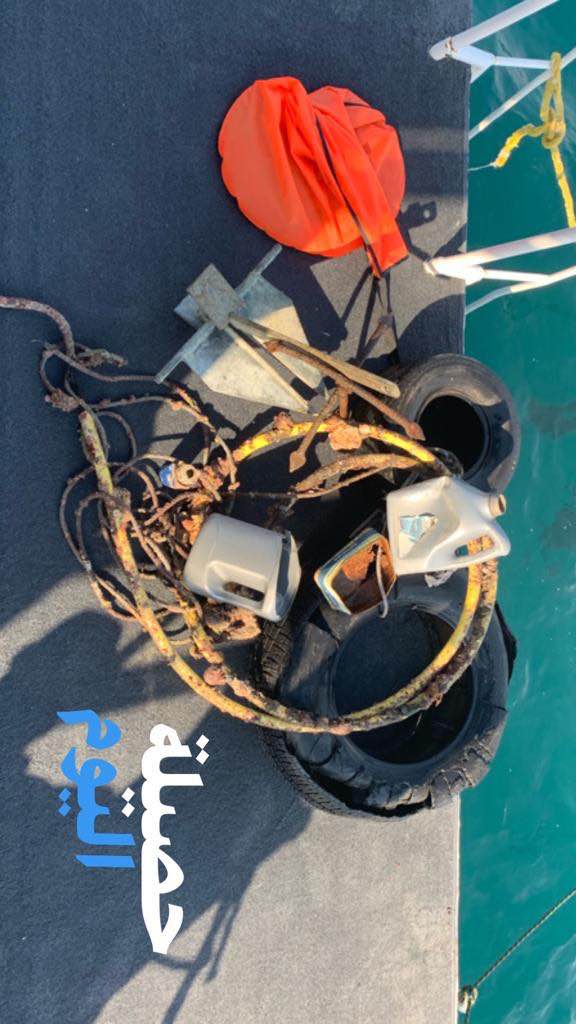
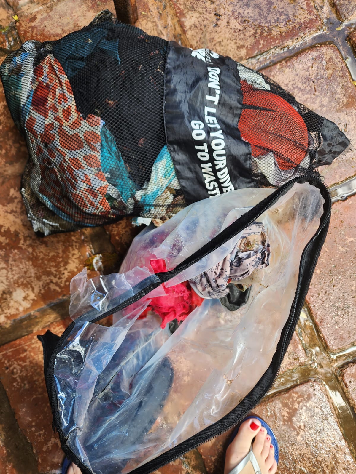
More items in this location. Trash pit. I couldn't carry anything more safely
Heavy winds and swells
1
Fiberglass boat hook
Liquid Adrenaline Divers
Larry harris
1
2
5.00
60
28.00
10.00
estimated
800.00
On
pounds
I have debris data to report
Slight for waves 0.5 -1.25 meter high ft2
feet
other
United States
State\Province
CA
City
Avalon
Map Help


Dive Location

If you know your survey site coordinates, enter them manually in decimal degrees using WGS84 Map Datum. Use the minus sign for latitudes south of the equator and longitudes west of the Prime Meridian to 180 degrees.

If you do not know your survey site coordinates, click the “Map Location” tab to use the map to zoom into your survey site and drop the pin on the map to fall within your survey dive site in the water (not on land or the beach). Ensure you zoom in as much as possible to ensure data accuracy.

Entangled Help


Use the vertical tabs below to record any entangled animals you found of each type.

Ecosystem Other
Sandy

Rig 1

0
0
0
1

5.018699316267, 114.88608241081

0
0
0
sand
0
0
0
1
0
Oceanic Quest
Janice
0
0
0
0
0
0
0
0
0
0
0
0
0
0
0
0
0
0
0
4
0
0
0
0
0
0
0
0
0
0
0
0
0
0
0
0
4.00
37
18.20
5.00
1
measured
0
0
0
0
20.00
0
0
0
0
0
0
On
kilograms
0
I have debris data to report
0
0
0
Slight for waves 0.5 -1.25 meter high
0
0
0
0
0
0
0
m2
0
0
meters
coral reef
0
0
0
0
0
0
0
0
0
0
0
0
0
0
0
0
0
0
0
0
0
0
0
0
0
0
0
0
0
Brunei
State\Province
Muara
City
Muara
Map Help


Dive Location

If you know your survey site coordinates, enter them manually in decimal degrees using WGS84 Map Datum. Use the minus sign for latitudes south of the equator and longitudes west of the Prime Meridian to 180 degrees.

If you do not know your survey site coordinates, click the “Map Location” tab to use the map to zoom into your survey site and drop the pin on the map to fall within your survey dive site in the water (not on land or the beach). Ensure you zoom in as much as possible to ensure data accuracy.

Entangled Help


Use the vertical tabs below to record any entangled animals you found of each type.

Bolkiah Wreck

0
0
0
1

5.130075532001, 114.98385760484

0
0
0
other
0
0
0
0
0
Janice
0
0
0
0
0
0
0
0
0
0
0
0
0
0
0
0
0
0
0
5
0
0
0
0
0
0
0
0
0
0
0
0
0
0
0
0
8.00
38
23.50
5.00
1
measured
0
0
0
0
215.00
0
0
0
0
0
0
On
kilograms
0
I have debris data to report
0
0
0
Slight for waves 0.5 -1.25 meter high
0
0
0
0
0
0
0
m2
0
0
meters
coral reef
0
0
0
0
0
0
0
0
0
0
0
0
0
0
0
0
0
0
0
0
0
0
0
0
0
0
0
0
0
Afghanistan
Map Help


Dive Location

If you know your survey site coordinates, enter them manually in decimal degrees using WGS84 Map Datum. Use the minus sign for latitudes south of the equator and longitudes west of the Prime Meridian to 180 degrees.

If you do not know your survey site coordinates, click the “Map Location” tab to use the map to zoom into your survey site and drop the pin on the map to fall within your survey dive site in the water (not on land or the beach). Ensure you zoom in as much as possible to ensure data accuracy.

Entangled Help


Use the vertical tabs below to record any entangled animals you found of each type.

Um almaradem

0
0
0
0

28.680756380579, 48.659112847347

0
0
0
sand
0
0
0
0
0
N/A
Tyres
Windy
Dive36
Faisal aldubayyan
0
0
0
0
0
0
0
0
0
0
0
0
0
0
0
0
0
0
0
2
0
0
0
0
0
0
0
1
1
1
0
0
0
0
0
0
5.00
30
15.00
5.00
0
estimated
0
0
3284.90
0
2
0
0
0
Fishing net
0
On
kilograms
0
I have debris data to report
0
0
0
Slight for waves 0.5 -1.25 meter high
0
0
0
0
0
0
0
m2
2
0
meters
coral reef
0
0
0
0
0
0
0
0
0
0
0
0
0
0
0
0
0
0
0
0
0
0
0
0
0
0
0
0
0
Kuwait
State\Province
Kuwait
City
Kuwait
Map Help


Dive Location

If you know your survey site coordinates, enter them manually in decimal degrees using WGS84 Map Datum. Use the minus sign for latitudes south of the equator and longitudes west of the Prime Meridian to 180 degrees.

If you do not know your survey site coordinates, click the “Map Location” tab to use the map to zoom into your survey site and drop the pin on the map to fall within your survey dive site in the water (not on land or the beach). Ensure you zoom in as much as possible to ensure data accuracy.

Entangled Help


Use the vertical tabs below to record any entangled animals you found of each type.

Crystal bay

26
11

-8.715681, 115.457371

coral
1
8
flooding and heavy rain
toy car & bucket
Drizzly
Indo Ocean Project
Mikhaela
1
2
8
2
1
1
12
2
1.28
50
16.90
1.00
1
measured
700.00
straws
plastic bags
food wrapper
On
kilograms
I have debris data to report
Slight for waves 0.5 -1.25 meter high m2
meters
coral reef
3
Indonesia
State\Province
Bali
City
Nusa Penida
Map Help


Dive Location

If you know your survey site coordinates, enter them manually in decimal degrees using WGS84 Map Datum. Use the minus sign for latitudes south of the equator and longitudes west of the Prime Meridian to 180 degrees.

If you do not know your survey site coordinates, click the “Map Location” tab to use the map to zoom into your survey site and drop the pin on the map to fall within your survey dive site in the water (not on land or the beach). Ensure you zoom in as much as possible to ensure data accuracy.

Entangled Help


Use the vertical tabs below to record any entangled animals you found of each type.

Coral Beach

0
17
0
0

-8.730812, 115.906088

0
0
0
coral
0
79
0
2
0
Heavy Rain
Bikini and swimming trunks
Rain
1
Toothpaste
SORCE
Ipan
0
0
0
21
0
0
0
0
0
2
8
0
0
0
17
0
0
0
0
7
0
0
1
0
93
0
1
0
0
0
0
0
0
0
0
0
9.60
55
24.00
2.00
1
measured
0
0
0
0
6046.08
0
0
0
0
0
0
On
kilograms
0
I have debris data to report
0
0
0
Calm (glassy to rippled) for waves 0 – 0.1 meter high
0
0
0
0
0
0
0
m2
0
0
meters
coral reef
0
0
0
0
0
1
0
0
0
2
0
0
0
4
0
0
0
0
0
0
0
0
0
0
0
0
0
0
0
Indonesia
Map Help


Dive Location

If you know your survey site coordinates, enter them manually in decimal degrees using WGS84 Map Datum. Use the minus sign for latitudes south of the equator and longitudes west of the Prime Meridian to 180 degrees.

If you do not know your survey site coordinates, click the “Map Location” tab to use the map to zoom into your survey site and drop the pin on the map to fall within your survey dive site in the water (not on land or the beach). Ensure you zoom in as much as possible to ensure data accuracy.

Entangled Help


Use the vertical tabs below to record any entangled animals you found of each type.

junkyard

4
7
sand
5

10.086824843246, 99.823546493037

plastic case
1
1
plastic case
electric cable
the coral tribe
jennifer dowling
2
10
1
2.50
43
14.00
6.00
estimated
1
180.00
plastic fragments
fishing line
spray cans
2
On
kilograms
I have debris data to report
Slight for waves 0.5 -1.25 meter high
1
m2
meters
coral reef
2
1
1
3
Thailand
State\Province
surat thani
City
koh tao
Map Help


Dive Location

If you know your survey site coordinates, enter them manually in decimal degrees using WGS84 Map Datum. Use the minus sign for latitudes south of the equator and longitudes west of the Prime Meridian to 180 degrees.

If you do not know your survey site coordinates, click the “Map Location” tab to use the map to zoom into your survey site and drop the pin on the map to fall within your survey dive site in the water (not on land or the beach). Ensure you zoom in as much as possible to ensure data accuracy.

Entangled Help


Use the vertical tabs below to record any entangled animals you found of each type.

junkyard

11
12
sand
13

10.086581894026, 99.823771798594

rubber scuba gear
2
14
rubber scuba gear
paint chipping
the coral tribe
jennifer dowling
4
4
4
6
11
2
4.50
55
13.00
5.00
estimated
1
180.00
1
fishing line
plastic fragments
food wrappers
On
kilograms
I have debris data to report
Slight for waves 0.5 -1.25 meter high
4
0
m2
7
meters
coral reef
2
3
1
Thailand
State\Province
surat thani
City
koh tao
Map Help


Dive Location

If you know your survey site coordinates, enter them manually in decimal degrees using WGS84 Map Datum. Use the minus sign for latitudes south of the equator and longitudes west of the Prime Meridian to 180 degrees.

If you do not know your survey site coordinates, click the “Map Location” tab to use the map to zoom into your survey site and drop the pin on the map to fall within your survey dive site in the water (not on land or the beach). Ensure you zoom in as much as possible to ensure data accuracy.

Entangled Help


Use the vertical tabs below to record any entangled animals you found of each type.

DROC - The Charamicos Wall

6
9

19.75565, -70.52336

coral
8
part of WiFi box
Hugh waves from the north

https://www.instagram.com/reel/CodhTkPMa_2/?igshid=MDJmNzVkMjY=
1
2
1
part of WiFi box
shoes ruber plastic
shoping bag?
Divecenter Merlin
Ema Stevanova
2
1
2
5
6.76
57
20.00
8.00
measured
3310.00
On
kilograms
I have debris data to report
Smooth (wavelets) for waves 0.1 - 0.5 meter high
19
m2
meters
coral reef
1
4
Dominican Republic
State\Province
Puerto Plata
City
Sosua
Map Help


Dive Location

If you know your survey site coordinates, enter them manually in decimal degrees using WGS84 Map Datum. Use the minus sign for latitudes south of the equator and longitudes west of the Prime Meridian to 180 degrees.

If you do not know your survey site coordinates, click the “Map Location” tab to use the map to zoom into your survey site and drop the pin on the map to fall within your survey dive site in the water (not on land or the beach). Ensure you zoom in as much as possible to ensure data accuracy.

Entangled Help


Use the vertical tabs below to record any entangled animals you found of each type.

DROC - The Charamicos Wall

3
2

19.75565, -70.52336

coral
Big waves from north

https://www.instagram.com/reel/CodhTkPMa_2/?igshid=MDJmNzVkMjY=
1
sanitary towel
Divecenter Merlin
Christian Harder
1
2
2
1
0.52
62
20.00
8.00
measured
3600.00
On
kilograms
I have debris data to report
Smooth (wavelets) for waves 0.1 - 0.5 meter high
3
m2
meters
coral reef
1
Dominican Republic
State\Province
Puerto Plata
City
Sosua
Map Help


Dive Location

If you know your survey site coordinates, enter them manually in decimal degrees using WGS84 Map Datum. Use the minus sign for latitudes south of the equator and longitudes west of the Prime Meridian to 180 degrees.

If you do not know your survey site coordinates, click the “Map Location” tab to use the map to zoom into your survey site and drop the pin on the map to fall within your survey dive site in the water (not on land or the beach). Ensure you zoom in as much as possible to ensure data accuracy.

Entangled Help


Use the vertical tabs below to record any entangled animals you found of each type.

Subscribe to