Menu

Port Vila Seafront

2
0
0

-17.73735484814, 168.31206092393

0
0
0
sand
0
2
0
0
0
Cyclone Pam in 2015 wrecked boats here
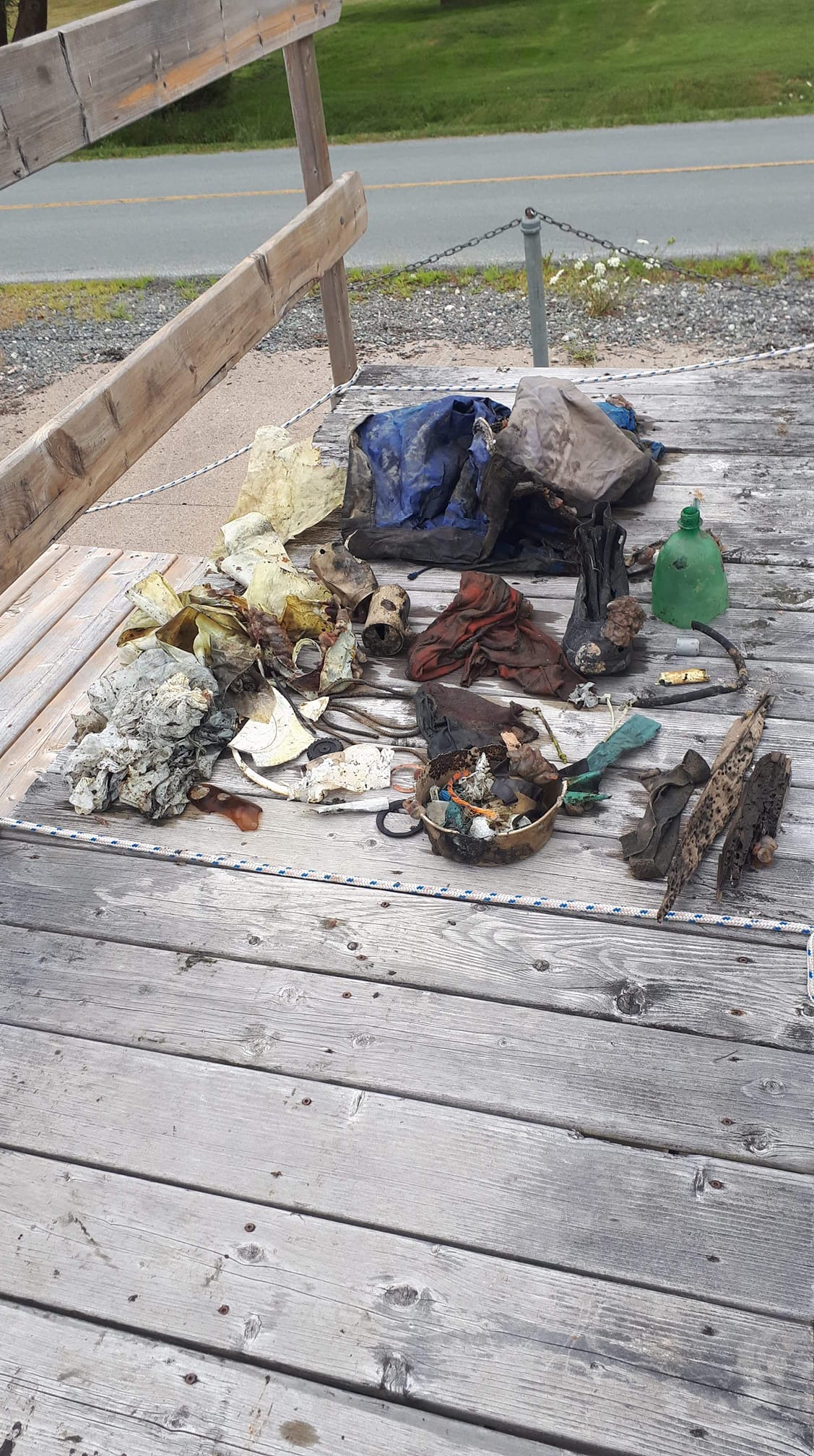
Cash box
Raining
4
1
1
1
1
1
1
0
0
0
0
0
0
0
0
0
0
0
0
0
Fibreglass pieces
Sunglasses
Cash box
Plastic mesh fencing
Metal boat parts
Umbrella
Paint roller tray
Big Blue Vanuatu
Martika Tahi
0
1
0
5
0
0
0
0
3
0
0
0
0
0
0
0
0
2
0
8
0
2
0
0
0
0
0
0
0
0
0
0
0
0
150.00
70
10.00
3.00
0
estimated
0
0
12488.10
0
1
0
0
0
Fibreglass
Ropes
0
On
kilograms
0
I have debris data to report
235
4
0
Slight for waves 0.5 -1.25 meter high
0
0
0
1
2
0
0
m2
12
0
meters
coral reef
0
0
6
0
0
1
0
0
0
0
0
1
0
0
0
2
61
0
0
2
0
2
0
0
0
0
0
0
Vanuatu
State\Province
Shefa
City
Port Vila
Map Help


Dive Location

If you know your survey site coordinates, enter them manually in decimal degrees using WGS84 Map Datum. Use the minus sign for latitudes south of the equator and longitudes west of the Prime Meridian to 180 degrees.

If you do not know your survey site coordinates, click the “Map Location” tab to use the map to zoom into your survey site and drop the pin on the map to fall within your survey dive site in the water (not on land or the beach). Ensure you zoom in as much as possible to ensure data accuracy.

Entangled Help


Use the vertical tabs below to record any entangled animals you found of each type.

The Crash

1
3
0

12.115313484305, -68.965440381378

0
1
0
coral
0
2
0
442
0
Santa Clara image.
Good
2
1
1
1
0
0
0
0
0
0
0
0
0
0
0
0
0
0
0
0
Candles
Saints images
Sunglasses
Tetrapak
Goby Divers
Tatiana Zanardi
0
0
0
2
0
0
0
0
0
0
0
0
0
0
0
0
0
0
1
11
0
0
0
0
0
0
0
0
0
0
0
0
0
0
28.50
65
15.00
2.00
4
measured
0
43
45378.00
0
0
0
1
0
Fishing lines and hooks
2
On
kilograms
0
I have debris data to report
9
0
0
Calm (glassy to rippled) for waves 0 – 0.1 meter high
0
0
0
0
2
0
0
m2
0
1
meters
coral reef
5
0
3
0
1
0
0
0
0
3
0
0
0
0
1
0
7
0
0
2
0
6
0
0
0
0
2
0
Netherlands Antilles
City
Willemstad
Map Help


Dive Location

If you know your survey site coordinates, enter them manually in decimal degrees using WGS84 Map Datum. Use the minus sign for latitudes south of the equator and longitudes west of the Prime Meridian to 180 degrees.

If you do not know your survey site coordinates, click the “Map Location” tab to use the map to zoom into your survey site and drop the pin on the map to fall within your survey dive site in the water (not on land or the beach). Ensure you zoom in as much as possible to ensure data accuracy.

Entangled Help


Use the vertical tabs below to record any entangled animals you found of each type.

Sandy Point State Park, East Beach

1
0
0

39.017213661778, -76.395779668261

1
0
0
silt
0
0
0
1
0
People fishing and swimming at the beach
Umbrella
Heavy rain the day before. Otherwise sunny and clear.
1
0
0
0
0
0
0
0
0
0
0
0
0
0
0
0
0
0
0
0
Umbrella
Blue Planet Scuba
Christina Hoenow
0
0
0
0
0
0
0
0
0
0
0
0
0
0
0
0
0
0
0
8
0
0
0
0
0
0
0
0
0
0
1
0
0
0
18.30
35
10.00
6.00
0
measured
0
0
331459.00
0
0
0
0
0
Glass
Fishing line
Plastic fragments
0
On
pounds
0
I have debris data to report
1
0
1
Smooth (wavelets) for waves 0.1 - 0.5 meter high
0
0
1
Inside umbrella
Small Crabs
Released Unharmed
2
0
0
0
0
ft2
0
0
feet
other
1
0
1
0
0
0
0
0
0
0
0
0
1
0
0
1
0
0
0
0
0
8
0
0
0
0
0
0
United States
State\Province
Md
City
Annapolis
Map Help


Dive Location

If you know your survey site coordinates, enter them manually in decimal degrees using WGS84 Map Datum. Use the minus sign for latitudes south of the equator and longitudes west of the Prime Meridian to 180 degrees.

If you do not know your survey site coordinates, click the “Map Location” tab to use the map to zoom into your survey site and drop the pin on the map to fall within your survey dive site in the water (not on land or the beach). Ensure you zoom in as much as possible to ensure data accuracy.

Entangled Help


Use the vertical tabs below to record any entangled animals you found of each type.

ADS216 - USCG Duane

0
0
0
0

24.98966667, -80.382

0
0
0
sand
0
0
0
8
0
Fishing
Rainbow Reef Dive Center/FKNMS
Nate F
0
0
0
0
0
0
0
0
0
0
0
0
0
0
0
0
0
0
0
1
0
0
0
0
0
0
0
0
0
0
0
0
0
0
0
0
1.00
40
100.00
65.00
0
estimated
0
0
0
3
19584.10
0
0
0
0
0
0
On
pounds
0
I have debris data to report
0
0
0
Calm (glassy to rippled) for waves 0 – 0.1 meter high
0
0
0
0
0
0
0
ft2
0
0
feet
coral reef
2
0
0
0
0
0
0
0
0
0
0
0
0
0
0
0
0
0
0
0
0
0
0
0
0
0
0
0
0
United States
State\Province
Florida
City
Key Largo
Map Help


Dive Location

If you know your survey site coordinates, enter them manually in decimal degrees using WGS84 Map Datum. Use the minus sign for latitudes south of the equator and longitudes west of the Prime Meridian to 180 degrees.

If you do not know your survey site coordinates, click the “Map Location” tab to use the map to zoom into your survey site and drop the pin on the map to fall within your survey dive site in the water (not on land or the beach). Ensure you zoom in as much as possible to ensure data accuracy.

Entangled Help


Use the vertical tabs below to record any entangled animals you found of each type.

Sellars Cove

14
1
silt
5
1

44.645979769537, -63.923680614054

We had to stick to the shallower areas due to terrible visibility in the deeper depths. Cory who was with me says there is a noticeable amount of change in the amount of garbage since he's been doing at least one clean up dive there a year. The garbage we found is mostly older garbage, thankfully we do not find newer garbage.
There were mussels attached to the larger items and the squids were laying their eggs on the larger items as well.
The floater jacket and the boot
The last week has been mostly sunny and clear with one thunder and lightning storm that had strong winds and downpour.
2
1
Floater jacket
Railway Tie
Raya Boudreau
2
1
1
35.00
60
15.00
6.00
1
estimated
22000.00
1
Railway tie - when they were made they were coated in a special oil which could still be degrading.
Plastic bags - there were signs of the critters eating the bags as a food source due to their being nibbles all over.
On
pounds
I have debris data to report
Smooth (wavelets) for waves 0.1 - 0.5 meter high
0
1
ft2
2
feet
other
1
2
0
3
2
2
1
1
Canada
State\Province
Nova Scotia
City
Glen Haven
Map Help


Dive Location

If you know your survey site coordinates, enter them manually in decimal degrees using WGS84 Map Datum. Use the minus sign for latitudes south of the equator and longitudes west of the Prime Meridian to 180 degrees.

If you do not know your survey site coordinates, click the “Map Location” tab to use the map to zoom into your survey site and drop the pin on the map to fall within your survey dive site in the water (not on land or the beach). Ensure you zoom in as much as possible to ensure data accuracy.

Entangled Help


Use the vertical tabs below to record any entangled animals you found of each type.

Ecosystem Other
mostly mud bottom with the odd patch of kelp

ADS223 - Saint Nicholas Bay

14
2
rock
2

37.789791850479, 23.879573223268

Sky Clear
1
Plastic Xmass tree branch
Diveness
Emmanouil Vrentzos
6
3
1
25.00
34
3.00
2.00
measured
2
100.00
On
kilograms
I have debris data to report
Smooth (wavelets) for waves 0.1 - 0.5 meter high
3
1
m2
meters
rocky reef
10
3
0
3
4
Greece
Map Help


Dive Location

If you know your survey site coordinates, enter them manually in decimal degrees using WGS84 Map Datum. Use the minus sign for latitudes south of the equator and longitudes west of the Prime Meridian to 180 degrees.

If you do not know your survey site coordinates, click the “Map Location” tab to use the map to zoom into your survey site and drop the pin on the map to fall within your survey dive site in the water (not on land or the beach). Ensure you zoom in as much as possible to ensure data accuracy.

Entangled Help


Use the vertical tabs below to record any entangled animals you found of each type.

Sellars Cove

13

44.6458, -63.923955

1
silt
5
1

44.645562494573, -63.921902408388

We stuck closer to the shore when we were cleaning up due to terrible visibility farther out. Cory who was with me has been doing at least one clean up dive a year at this spot and he says there is a noticeable difference in the amount of garbage compared to when he first started; Now he has to go further out and along to find the garbage.
A lot of the debris found is really old, and thankfully there aren't many newer pieces of garbage. There are a lot of boats docked in the area so many items could have come from boats sinking over the years
Floater coat and a Boot
Weather had been clear for the most part with one thunder and lightning storm with strong winds and downpour.
1
1
floater coat
railway tie
Individuals
Raya Boudreau
1
2
1
1
1
4
30.00
60
15.00
8.00
estimated
22000.00
1
Plastic bags - you could see that the critters in the water were nibbling on the bags as a food source
Railway tie- when they were created they were coated in an oil that is harmful and could still be degrading.
On
pounds
I have debris data to report
Smooth (wavelets) for waves 0.1 - 0.5 meter high
2
1
0
ft2
2
2
feet
other
1
2
3
2
2
1
1
Canada
State\Province
Nova Scotia
City
Glen Haven
Map Help


Dive Location

If you know your survey site coordinates, enter them manually in decimal degrees using WGS84 Map Datum. Use the minus sign for latitudes south of the equator and longitudes west of the Prime Meridian to 180 degrees.

If you do not know your survey site coordinates, click the “Map Location” tab to use the map to zoom into your survey site and drop the pin on the map to fall within your survey dive site in the water (not on land or the beach). Ensure you zoom in as much as possible to ensure data accuracy.

Entangled Help


Use the vertical tabs below to record any entangled animals you found of each type.

Ecosystem Other
mostly jusst mud bottom, with the odd bunches of kelp

Storsand, Sætre, Norway

59.650977, 10.608147

1
sand
3

59.6509808, 10.5985988

Monica Stolen Dønnum
2
1.00
35
30.00
20.00
estimated
1
5.00
On
kilograms
I have debris data to report
Calm (glassy to rippled) for waves 0 – 0.1 meter high m2
meters
rocky reef
Norway
Map Help


Dive Location

If you know your survey site coordinates, enter them manually in decimal degrees using WGS84 Map Datum. Use the minus sign for latitudes south of the equator and longitudes west of the Prime Meridian to 180 degrees.

If you do not know your survey site coordinates, click the “Map Location” tab to use the map to zoom into your survey site and drop the pin on the map to fall within your survey dive site in the water (not on land or the beach). Ensure you zoom in as much as possible to ensure data accuracy.

Entangled Help


Use the vertical tabs below to record any entangled animals you found of each type.

ADS314 - Shark Island

0
0
0
0

25.353533, 56.376133

0
0
0
coral
0
3
0
0
0
N/A
Hassan NK Khayal
0
0
0
0
0
0
0
0
0
0
0
0
0
0
0
0
0
0
0
2
0
0
0
0
0
0
5
0
0
0
0
0
0
0
0
0
0.10
60
8.00
3.00
0
estimated
0
0
0
0
50.00
0
0
0
0
0
0
On
kilograms
0
I have debris data to report
0
0
0
Calm (glassy to rippled) for waves 0 – 0.1 meter high
0
0
0
0
0
0
0
m2
0
0
meters
coral reef
0
0
0
0
0
0
0
0
0
0
0
0
0
0
0
0
0
0
0
0
0
0
0
0
0
0
0
0
0
United Arab Emirates
Map Help


Dive Location

If you know your survey site coordinates, enter them manually in decimal degrees using WGS84 Map Datum. Use the minus sign for latitudes south of the equator and longitudes west of the Prime Meridian to 180 degrees.

If you do not know your survey site coordinates, click the “Map Location” tab to use the map to zoom into your survey site and drop the pin on the map to fall within your survey dive site in the water (not on land or the beach). Ensure you zoom in as much as possible to ensure data accuracy.

Entangled Help


Use the vertical tabs below to record any entangled animals you found of each type.

ADS268 - Dibba Rock

0
0
0
0

25.6025977, 56.351134

0
0
0
coral
0
0
0
0
0
N/A
Hassan NK Khayal
0
0
0
0
0
0
0
0
0
0
0
0
0
0
0
0
0
0
0
2
0
0
0
0
0
0
0
0
0
0
0
0
0
0
0
0
0.00
60
14.00
4.00
0
estimated
0
0
0
0
50.00
0
0
0
0
0
0
On
kilograms
0
Our Survey Site was free of debris
0
0
0
Calm (glassy to rippled) for waves 0 – 0.1 meter high
0
0
0
0
0
0
0
m2
0
0
meters
coral reef
0
0
0
0
0
0
0
0
0
0
0
0
0
0
0
0
0
0
0
0
0
0
0
0
0
0
0
0
0
United Arab Emirates
Map Help


Dive Location

If you know your survey site coordinates, enter them manually in decimal degrees using WGS84 Map Datum. Use the minus sign for latitudes south of the equator and longitudes west of the Prime Meridian to 180 degrees.

If you do not know your survey site coordinates, click the “Map Location” tab to use the map to zoom into your survey site and drop the pin on the map to fall within your survey dive site in the water (not on land or the beach). Ensure you zoom in as much as possible to ensure data accuracy.

Entangled Help


Use the vertical tabs below to record any entangled animals you found of each type.

Subscribe to