Menu

ADS521 - Mirette Reef

30
3

27.249011086595, 33.847801618413

6
coral
0
10
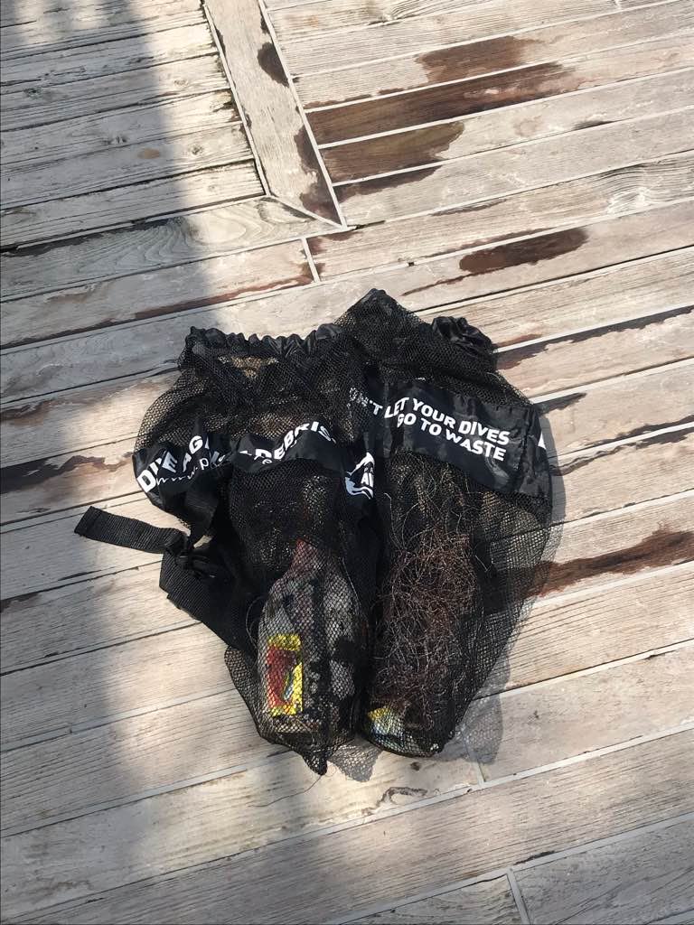
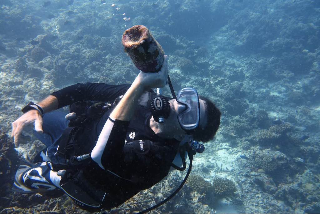
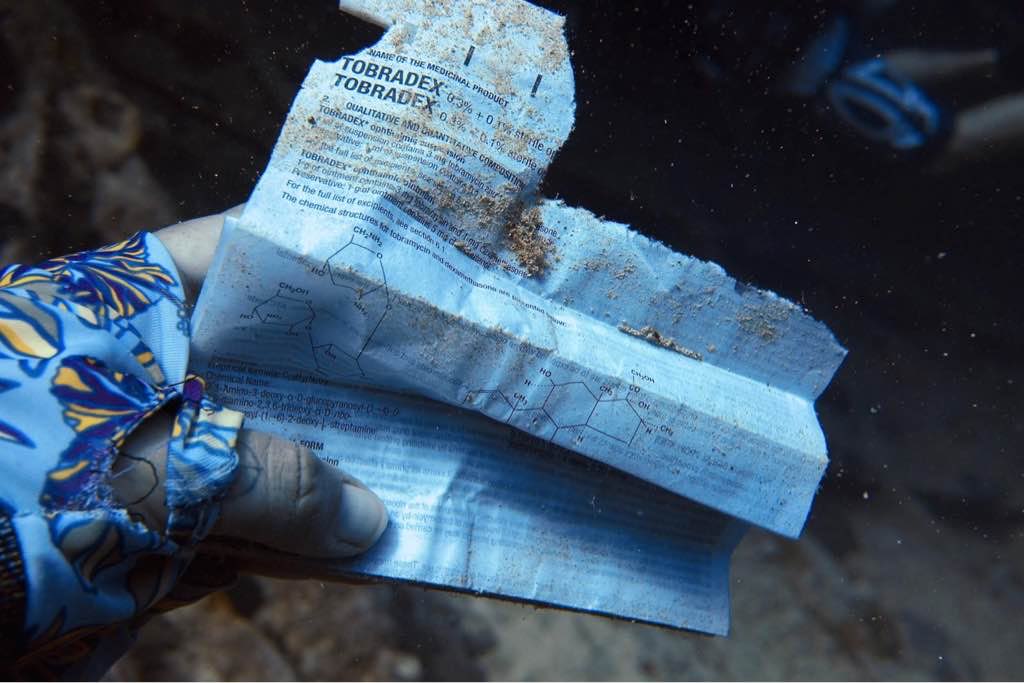
After qurantine stop - there are not so many debris, onle plastic. And no one mask)
There are no photos to publicate. I have this, but goverment of ARE dont allows no any share. May be later its possible
plastic
calm
Crazy Dolphins
Stanislav Yurchenko
4
5
5
4
11
7
6
2
2
11.00
75
18.00
4.00
6
estimated
10
5
130.00
On
kilograms
I have debris data to report
Calm (glassy to rippled) for waves 0 – 0.1 meter high m2
meters
coral reef
Egypt
State\Province
Hurghada
City
Hurghada
Map Help


Dive Location

If you know your survey site coordinates, enter them manually in decimal degrees using WGS84 Map Datum. Use the minus sign for latitudes south of the equator and longitudes west of the Prime Meridian to 180 degrees.

If you do not know your survey site coordinates, click the “Map Location” tab to use the map to zoom into your survey site and drop the pin on the map to fall within your survey dive site in the water (not on land or the beach). Ensure you zoom in as much as possible to ensure data accuracy.

Entangled Help


Use the vertical tabs below to record any entangled animals you found of each type.

Galhu Falhu

2
0
0

4.1686084684802, 73.48232686198

0
0
0
coral
0
0
0
25
0
Fishermen
Clear
0
0
0
0
0
0
0
0
0
0
0
0
0
0
0
0
0
0
0
0
Scubaspa Yang
Kashif Hilmy
0
0
0
0
0
0
0
0
0
0
0
0
0
0
0
0
0
0
0
4
0
1
0
0
0
0
0
0
0
0
0
0
0
0
1.50
50
20.00
5.00
0
estimated
0
2
414.99
0
0
0
0
0
Fishing lines
0
On
kilograms
0
I have debris data to report
1
0
0
Calm (glassy to rippled) for waves 0 – 0.1 meter high
0
0
0
0
0
0
0
m2
0
0
meters
coral reef
0
0
0
0
0
0
0
0
0
0
0
0
0
0
0
0
0
0
0
0
0
0
0
0
0
0
0
0
Maldives
State\Province
Kaafu
City
Hulhumale
Map Help


Dive Location

If you know your survey site coordinates, enter them manually in decimal degrees using WGS84 Map Datum. Use the minus sign for latitudes south of the equator and longitudes west of the Prime Meridian to 180 degrees.

If you do not know your survey site coordinates, click the “Map Location” tab to use the map to zoom into your survey site and drop the pin on the map to fall within your survey dive site in the water (not on land or the beach). Ensure you zoom in as much as possible to ensure data accuracy.

Entangled Help


Use the vertical tabs below to record any entangled animals you found of each type.

Green Rock Wall

7
1

10.123874901511, 99.811062828371

sand
1
3

10.123874901511, 99.811062828371

Recent tropical storm in Thailand
Decomposing plastic bag
Windy, stormy
ecoTrust
Piers
9
3
12
1.50
50
20.00
13.00
estimated
4000.00
On
kilograms
I have debris data to report
Smooth (wavelets) for waves 0.1 - 0.5 meter high m2
meters
coral reef
Thailand
State\Province
Suratthani
City
Koh Tao
Map Help


Dive Location

If you know your survey site coordinates, enter them manually in decimal degrees using WGS84 Map Datum. Use the minus sign for latitudes south of the equator and longitudes west of the Prime Meridian to 180 degrees.

If you do not know your survey site coordinates, click the “Map Location” tab to use the map to zoom into your survey site and drop the pin on the map to fall within your survey dive site in the water (not on land or the beach). Ensure you zoom in as much as possible to ensure data accuracy.

Entangled Help


Use the vertical tabs below to record any entangled animals you found of each type.

Carysfort

0
0
0

25.116687610694, -80.302569098836

0
0
0
coral
0
1
0
0
0
Lobster season, tropical storm
Burlap sack
Tropical Storm
0
0
0
0
0
0
0
0
0
0
0
0
0
0
0
0
0
0
0
0
Pirates Cove Watersports
Michael R
0
0
0
0
0
0
0
0
0
0
0
0
0
0
0
0
0
0
0
6
0
0
0
0
0
0
0
0
0
0
0
0
0
5
30.00
40
60.00
30.00
0
estimated
1
0
300.00
0
0
0
0
0
Anchor line
0
On
pounds
0
I have debris data to report
1
0
0
Slight for waves 0.5 -1.25 meter high
0
0
0
Traps
Crab
Released Unharmed
6
1
1
0
1
ft2
0
0
feet
coral reef
0
0
0
0
0
0
0
0
0
0
0
0
0
0
2
0
2
0
0
0
0
0
0
0
0
0
0
0
United States
State\Province
FL
City
Key Largo
Map Help


Dive Location

If you know your survey site coordinates, enter them manually in decimal degrees using WGS84 Map Datum. Use the minus sign for latitudes south of the equator and longitudes west of the Prime Meridian to 180 degrees.

If you do not know your survey site coordinates, click the “Map Location” tab to use the map to zoom into your survey site and drop the pin on the map to fall within your survey dive site in the water (not on land or the beach). Ensure you zoom in as much as possible to ensure data accuracy.

Entangled Help


Use the vertical tabs below to record any entangled animals you found of each type.

Lighthouse

19
158
0

28.498899880772, 34.519706112689

0
0
0
sand
0
0
0
2
0
No
Sunny, calm
14
2
11
1
54
31
0
0
0
0
0
0
0
0
0
0
0
0
0
0
Ceramic tiles
Wet wipes
Chewing gum
Sanitary pad
Mixed material fragments
Water bottle plastic seals
Red Sea Tribe
Rachel Shelley
0
0
0
2
498
0
0
0
0
0
3
0
0
0
0
0
24
31
22
18
0
0
0
0
0
0
0
0
0
0
0
0
0
0
10.00
45
22.00
1.00
0
estimated
0
4
4859.67
0
0
0
0
0
Cigarette butts
Plastic water bottle seals
Plastic bottles
0
On
kilograms
0
I have debris data to report
2
0
0
Calm (glassy to rippled) for waves 0 – 0.1 meter high
2
0
0
0
0
0
0
m2
0
0
meters
coral reef
0
0
0
0
0
19
0
20
0
0
0
0
5
0
1
0
11
0
0
0
0
14
0
1
0
0
0
0
Egypt
State\Province
South Sinai
City
Dahab
Map Help


Dive Location

If you know your survey site coordinates, enter them manually in decimal degrees using WGS84 Map Datum. Use the minus sign for latitudes south of the equator and longitudes west of the Prime Meridian to 180 degrees.

If you do not know your survey site coordinates, click the “Map Location” tab to use the map to zoom into your survey site and drop the pin on the map to fall within your survey dive site in the water (not on land or the beach). Ensure you zoom in as much as possible to ensure data accuracy.

Entangled Help


Use the vertical tabs below to record any entangled animals you found of each type.

ADS584 - Holyrood Marina

6

47.389297, -53.126558

silt
Who has more fun that newly minted divers? The old dog who helped them earn their certifications, that's who! Congrats to Ocean Quest Adventures OW/Drysuit divers from course OW-2020-004, Tara J, Scott W, Ajat B and the toughest of us all Aidan T. The toughest?? The first to certify in a wetsuit this year! And thanks to our DM Cassandra K and DMT Alain L. This group was already looking to collect debris on their second open water dive. Rather than collecting, we mentally surveyed the area for a later assault on debris. It was hard to hold them back. When it was time we broke into two teams for a short tour and a collection effort. The candidates had already completed their open water dives and were doing their drysuit certification dive in rather poor vis. It made the collection a tad more challenging. What made it easy, their environmental awareness and really good buoyancy. There is no doubt that our continuing presence and effort at this dive site is making the sailors from the adjacent marina more alert to the environmental impact caused by dumping debris in the sea. It is a little rewarding when they pat us on the back for our efforts. Way to go divers! Way to go sailors! This Project AWARE thing is working.
Overcast, rainy, cool, windy
1
Aluminum siding
Ocean Quest Adventures
Mark McGowan
1
6
1
25.00
25
35.00
20.00
estimated
7000.00
Glass beverage containers represented about 80% of the debris removed today.
On
pounds
I have debris data to report
33
Smooth (wavelets) for waves 0.1 - 0.5 meter high ft2
feet
kelp
1
1
Canada
State\Province
NL
City
Holyrood
Map Help


Dive Location

If you know your survey site coordinates, enter them manually in decimal degrees using WGS84 Map Datum. Use the minus sign for latitudes south of the equator and longitudes west of the Prime Meridian to 180 degrees.

If you do not know your survey site coordinates, click the “Map Location” tab to use the map to zoom into your survey site and drop the pin on the map to fall within your survey dive site in the water (not on land or the beach). Ensure you zoom in as much as possible to ensure data accuracy.

Entangled Help


Use the vertical tabs below to record any entangled animals you found of each type.

Abades Montana Falda

3
rock
5
1

28.140961052494, -16.43973173284

Sadly there seem to be more fishers in the bay, dispite it being a marine protected area. Perhaps the Covid-19 event is contributing to people losing their jobs and having to fish in other areas.
The anchor weighed 2.5 kg, making up most of the weight of the debris collected
Small boat anchor (fishing boat) on a rope
Windy, but calm in the bay
Tenerife Diving Academy
Kim Timmers
7
2.90
36
6.60
4.40
measured
3
650.00
Fishing hooks
Fishing line
Polistyrene
On
kilograms
I have debris data to report
Smooth (wavelets) for waves 0.1 - 0.5 meter high
1
m2
1
meters
rocky reef
1
4
Spain
State\Province
Tenerife
City
Abades`
Map Help


Dive Location

If you know your survey site coordinates, enter them manually in decimal degrees using WGS84 Map Datum. Use the minus sign for latitudes south of the equator and longitudes west of the Prime Meridian to 180 degrees.

If you do not know your survey site coordinates, click the “Map Location” tab to use the map to zoom into your survey site and drop the pin on the map to fall within your survey dive site in the water (not on land or the beach). Ensure you zoom in as much as possible to ensure data accuracy.

Entangled Help


Use the vertical tabs below to record any entangled animals you found of each type.

Tuvsjyen

67.221114, 14.649645

rock
1
1
Paint brush roll
fishing rod piece
Saltstraumen DykkeCamp
Fredric Ihrsen
1
1.50
39
21.00
3.00
measured
2
2500.00
On
kilograms
I have debris data to report
Smooth (wavelets) for waves 0.1 - 0.5 meter high
1
m2
meters
kelp
Norway
Map Help


Dive Location

If you know your survey site coordinates, enter them manually in decimal degrees using WGS84 Map Datum. Use the minus sign for latitudes south of the equator and longitudes west of the Prime Meridian to 180 degrees.

If you do not know your survey site coordinates, click the “Map Location” tab to use the map to zoom into your survey site and drop the pin on the map to fall within your survey dive site in the water (not on land or the beach). Ensure you zoom in as much as possible to ensure data accuracy.

Entangled Help


Use the vertical tabs below to record any entangled animals you found of each type.

ADS116 - Tunnelen

67.234674, 14.604692

10
rock
18
Saltstraumen DykkeCamp
Fredric Ihrsen
4
2.90
57
27.00
5.00
measured
32
2000.00
On
kilograms
I have debris data to report
Smooth (wavelets) for waves 0.1 - 0.5 meter high m2
meters
kelp
Norway
Map Help


Dive Location

If you know your survey site coordinates, enter them manually in decimal degrees using WGS84 Map Datum. Use the minus sign for latitudes south of the equator and longitudes west of the Prime Meridian to 180 degrees.

If you do not know your survey site coordinates, click the “Map Location” tab to use the map to zoom into your survey site and drop the pin on the map to fall within your survey dive site in the water (not on land or the beach). Ensure you zoom in as much as possible to ensure data accuracy.

Entangled Help


Use the vertical tabs below to record any entangled animals you found of each type.

Tokong Burung

0
0
0
0

5.962554, 102.675235

0
0
0
coral
0
0
1
0
0
local man made debris
yes
ghost net will be removed on 19th august
steel anchor
Calm and Sunny
1
Anchor
Perhentian Island divers
Andy Lua
0
0
0
0
0
0
0
0
0
0
0
0
0
0
0
0
0
0
0
5
0
0
0
0
0
0
0
0
2
0
0
0
0
0
0
0
25.00
45
20.00
10.00
0
estimated
0
0
0
0
300.00
0
0
0
0
0
plastic
fishing net
cigarette butts
0
On
kilograms
0
I have debris data to report
1
0
0
Calm (glassy to rippled) for waves 0 – 0.1 meter high
0
0
0
0
0
0
0
m2
1
0
meters
coral reef
0
0
1
0
0
0
0
0
0
0
0
0
0
0
0
0
0
2
0
0
0
0
0
0
0
0
0
0
0
Malaysia
State\Province
kuala besut Terengganu
City
Perhentian island
Map Help


Dive Location

If you know your survey site coordinates, enter them manually in decimal degrees using WGS84 Map Datum. Use the minus sign for latitudes south of the equator and longitudes west of the Prime Meridian to 180 degrees.

If you do not know your survey site coordinates, click the “Map Location” tab to use the map to zoom into your survey site and drop the pin on the map to fall within your survey dive site in the water (not on land or the beach). Ensure you zoom in as much as possible to ensure data accuracy.

Entangled Help


Use the vertical tabs below to record any entangled animals you found of each type.

Subscribe to