Menu

ADS10 - Ørneset

67.225682, 14.616451

15
rock
1
55
Saltstraumen DykkeCamp
Fredric Ihrsen
1
3.90
58
22.00
1.00
measured
63
2500.00
On
kilograms
I have debris data to report
Smooth (wavelets) for waves 0.1 - 0.5 meter high m2
meters
kelp
1
Norway
Map Help


Dive Location

If you know your survey site coordinates, enter them manually in decimal degrees using WGS84 Map Datum. Use the minus sign for latitudes south of the equator and longitudes west of the Prime Meridian to 180 degrees.

If you do not know your survey site coordinates, click the “Map Location” tab to use the map to zoom into your survey site and drop the pin on the map to fall within your survey dive site in the water (not on land or the beach). Ensure you zoom in as much as possible to ensure data accuracy.

Entangled Help


Use the vertical tabs below to record any entangled animals you found of each type.

Tuvveggen

67.222453, 14.627599

5
rock
5
Saltstraumen DykkeCamp
Fredric Ihrsen
1
0.50
47
30.00
5.00
measured
1
2000.00
On
kilograms
I have debris data to report
Smooth (wavelets) for waves 0.1 - 0.5 meter high m2
meters
kelp
Norway
Map Help


Dive Location

If you know your survey site coordinates, enter them manually in decimal degrees using WGS84 Map Datum. Use the minus sign for latitudes south of the equator and longitudes west of the Prime Meridian to 180 degrees.

If you do not know your survey site coordinates, click the “Map Location” tab to use the map to zoom into your survey site and drop the pin on the map to fall within your survey dive site in the water (not on land or the beach). Ensure you zoom in as much as possible to ensure data accuracy.

Entangled Help


Use the vertical tabs below to record any entangled animals you found of each type.

ADS116 - Tunnelen

1

67.234674, 14.604692

9
rock
10
Saltstraumen DykkeCamp
Fredric Ihrsen
2
1.10
50
27.00
5.00
measured
16
2000.00
On
kilograms
I have debris data to report
Smooth (wavelets) for waves 0.1 - 0.5 meter high m2
meters
kelp
Norway
Map Help


Dive Location

If you know your survey site coordinates, enter them manually in decimal degrees using WGS84 Map Datum. Use the minus sign for latitudes south of the equator and longitudes west of the Prime Meridian to 180 degrees.

If you do not know your survey site coordinates, click the “Map Location” tab to use the map to zoom into your survey site and drop the pin on the map to fall within your survey dive site in the water (not on land or the beach). Ensure you zoom in as much as possible to ensure data accuracy.

Entangled Help


Use the vertical tabs below to record any entangled animals you found of each type.

ADS586 - Lake Dlinnoe. The Island

60.299125381906, 29.297378745896

silt
3
We'd made first clin up after pandemia. The result of debries - people came back to the lake.
teapot
sun, surface +17, bottom +10. bo wind
Tortuga
Elena Nayda
1
1
1
8
1
1
3
1
6.00
35
9.00
1.50
1
estimated
80.00
On
kilograms
I have debris data to report
3
Calm (glassy to rippled) for waves 0 – 0.1 meter high
non
8
Released Unharmed
perch
m2
1
meters
seagrass
3
1
1
2
Russia
City
St-Petersburg
Map Help


Dive Location

If you know your survey site coordinates, enter them manually in decimal degrees using WGS84 Map Datum. Use the minus sign for latitudes south of the equator and longitudes west of the Prime Meridian to 180 degrees.

If you do not know your survey site coordinates, click the “Map Location” tab to use the map to zoom into your survey site and drop the pin on the map to fall within your survey dive site in the water (not on land or the beach). Ensure you zoom in as much as possible to ensure data accuracy.

Entangled Help


Use the vertical tabs below to record any entangled animals you found of each type.

ADS536 - Rye Pier

0
0
0

-38.369382, 144.822742

0
0
0
sand
0
0
0
0
0
No
Lanyard
Calm, light winds
11
0
0
0
0
0
0
0
0
0
0
0
0
0
0
0
0
0
0
0
Fishing lures & hooks
Ocean Divers
Jane Bowman & Liz Harper
0
0
0
0
0
0
0
0
0
0
0
0
0
0
0
0
0
0
0
14
0
0
0
0
0
0
0
0
0
0
0
0
0
0
5.00
75
7.00
3.00
0
estimated
0
0
35.17
0
0
0
0
0
Fishing line
Squid jigs
0
On
kilograms
0
I have debris data to report
7
0
0
Smooth (wavelets) for waves 0.1 - 0.5 meter high
0
0
0
0
0
0
0
m2
0
0
meters
rocky reef
0
0
0
0
0
6
0
0
0
0
0
0
0
0
0
0
2
0
0
0
0
0
0
3
0
0
0
0
Australia
State\Province
Victoria
City
Rye
Map Help


Dive Location

If you know your survey site coordinates, enter them manually in decimal degrees using WGS84 Map Datum. Use the minus sign for latitudes south of the equator and longitudes west of the Prime Meridian to 180 degrees.

If you do not know your survey site coordinates, click the “Map Location” tab to use the map to zoom into your survey site and drop the pin on the map to fall within your survey dive site in the water (not on land or the beach). Ensure you zoom in as much as possible to ensure data accuracy.

Entangled Help


Use the vertical tabs below to record any entangled animals you found of each type.

Mosquito Lake

3
0
1

50.337456999791, -122.748164

3
0
0
silt
0
0
2
0
0
No
Mixed
1
1
3
0
0
0
0
0
0
0
0
0
0
0
0
0
0
0
0
0
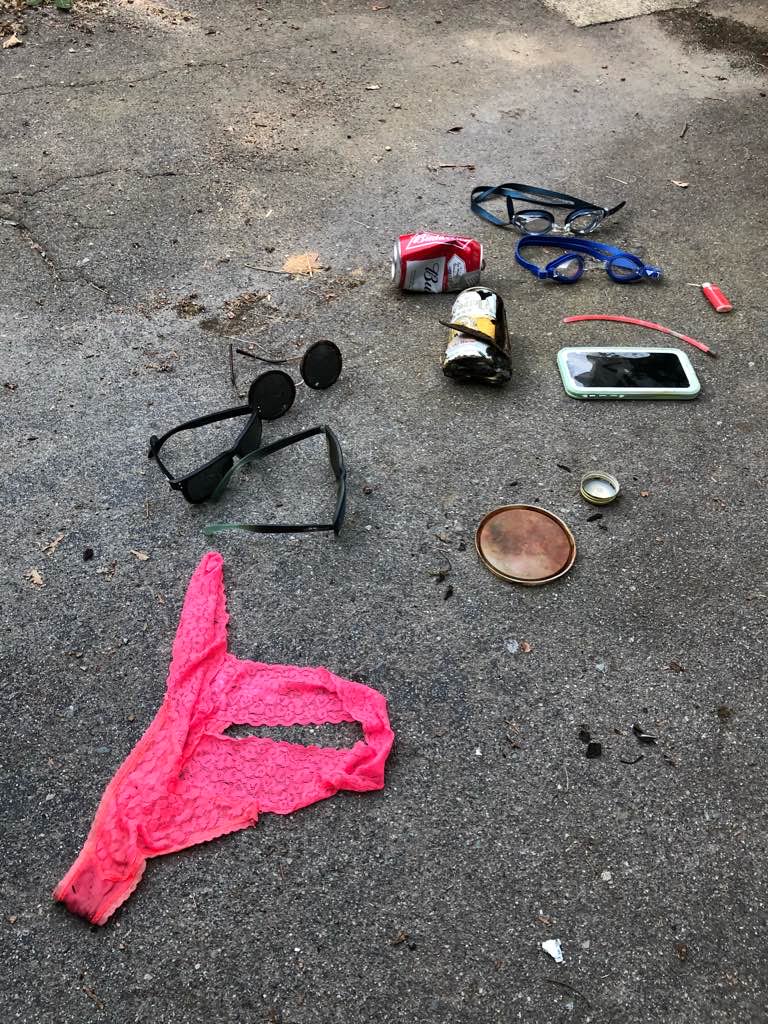
Lawn chair
Jewelry
Sunglasses
Divers for Cleaner Lakes and Oceans
Henry Wang
0
0
0
1
0
0
0
0
0
0
0
0
0
0
0
1
0
1
0
3
0
0
0
1
0
0
0
0
0
0
1
0
0
0
16.80
30
30.00
3.00
0
measured
0
0
800.00
0
0
0
0
0
Beer cans
0
On
pounds
0
I have debris data to report
2
0
0
Calm (glassy to rippled) for waves 0 – 0.1 meter high
0
0
0
0
2
0
0
ft2
0
0
feet
other
0
0
0
0
0
0
0
0
0
2
0
0
0
0
0
0
21
0
0
0
0
0
0
0
0
0
0
0
Canada
State\Province
British Columbia
City
Pemberton
Map Help


Dive Location

If you know your survey site coordinates, enter them manually in decimal degrees using WGS84 Map Datum. Use the minus sign for latitudes south of the equator and longitudes west of the Prime Meridian to 180 degrees.

If you do not know your survey site coordinates, click the “Map Location” tab to use the map to zoom into your survey site and drop the pin on the map to fall within your survey dive site in the water (not on land or the beach). Ensure you zoom in as much as possible to ensure data accuracy.

Entangled Help


Use the vertical tabs below to record any entangled animals you found of each type.

Cat Lake

0
0
0

49.79928872511, -123.11029190557

0
0
0
silt
0
0
1
0
0
No
Underwear
Sunny
3
0
0
0
0
0
0
0
0
0
0
0
0
0
0
0
0
0
0
0
Sunglasses
Divers for Cleaner Lakes and Oceans
Henry Wang
0
0
0
0
0
0
0
0
2
0
0
0
0
0
0
0
0
1
0
1
0
0
0
0
0
0
0
0
0
0
0
0
0
0
1.20
10
20.00
3.00
0
measured
0
0
100.00
0
0
0
0
0
0
On
pounds
0
I have debris data to report
0
0
0
Calm (glassy to rippled) for waves 0 – 0.1 meter high
0
0
0
0
0
0
0
ft2
0
0
feet
other
0
0
0
0
0
1
0
0
0
1
1
0
0
0
0
0
0
2
0
0
0
0
0
0
0
0
0
0
0
Canada
State\Province
British Columbia
City
Squamish
Map Help


Dive Location

If you know your survey site coordinates, enter them manually in decimal degrees using WGS84 Map Datum. Use the minus sign for latitudes south of the equator and longitudes west of the Prime Meridian to 180 degrees.

If you do not know your survey site coordinates, click the “Map Location” tab to use the map to zoom into your survey site and drop the pin on the map to fall within your survey dive site in the water (not on land or the beach). Ensure you zoom in as much as possible to ensure data accuracy.
Entangled Help


Use the vertical tabs below to record any entangled animals you found of each type.

Atton's Lake Public Beach

0
0
0
0

52.838044, -108.86196

0
0
0
silt
0
0
4
0
0
Remnant of 45 gallon drm
Rain showers, hot, windy
1
Sunglasses
Battlefords Scuba Community
Dennis McCullough
0
0
0
1
0
0
0
0
3
0
0
0
1
0
0
0
0
0
1
17
0
0
1
0
0
0
6
0
0
0
0
0
10
0
0
0
20.00
45
8.00
3.00
0
estimated
0
0
0
0
30036.20
0
0
0
0
0
Drink cans
Drink bottles
0
On
kilograms
0
I have debris data to report
1
0
0
Calm (glassy to rippled) for waves 0 – 0.1 meter high
0
0
0
0
1
0
0
m2
0
0
meters
other
0
0
0
1
0
0
0
0
0
5
0
0
0
0
0
0
0
22
0
0
0
0
0
0
0
0
0
0
0
Canada
State\Province
Saskatchewan
City
Cut Knife
Map Help


Dive Location

If you know your survey site coordinates, enter them manually in decimal degrees using WGS84 Map Datum. Use the minus sign for latitudes south of the equator and longitudes west of the Prime Meridian to 180 degrees.

If you do not know your survey site coordinates, click the “Map Location” tab to use the map to zoom into your survey site and drop the pin on the map to fall within your survey dive site in the water (not on land or the beach). Ensure you zoom in as much as possible to ensure data accuracy.

Entangled Help


Use the vertical tabs below to record any entangled animals you found of each type.

Atton's Lake Boat Launch

3
0
0
0

52.841397, -108.8682

0
0
0
silt
0
0
0
0
0
Recreational boating
Cool and dry, intermittent winds
Battlefords Scuba Community
Dennis McCullough
0
0
1
0
0
0
0
0
0
0
0
0
0
0
0
0
0
0
0
4
0
0
0
0
0
0
4
0
0
0
0
0
2
0
0
0
0.50
40
14.00
2.00
0
estimated
0
0
0
0
25751.20
0
0
0
0
0
0
On
kilograms
0
I have debris data to report
1
0
0
Calm (glassy to rippled) for waves 0 – 0.1 meter high
0
0
0
0
0
0
0
m2
0
0
meters
other
0
0
0
0
0
0
0
0
0
0
0
0
0
0
0
0
0
2
0
0
0
0
0
0
0
0
0
0
0
Canada
State\Province
Saskatchewan
City
Cut Knife
Map Help


Dive Location

If you know your survey site coordinates, enter them manually in decimal degrees using WGS84 Map Datum. Use the minus sign for latitudes south of the equator and longitudes west of the Prime Meridian to 180 degrees.

If you do not know your survey site coordinates, click the “Map Location” tab to use the map to zoom into your survey site and drop the pin on the map to fall within your survey dive site in the water (not on land or the beach). Ensure you zoom in as much as possible to ensure data accuracy.

Entangled Help


Use the vertical tabs below to record any entangled animals you found of each type.

Atton's Lake Boat Launch

0
4
0
0

52.841177, -108.86898

2
0
0
silt
0
0
0
2
0
Recreational boating
Canadian flag
Cool and dry, intermittent winds
Battlefords Sciba Community
Dennis McCullough
0
0
0
2
0
0
0
0
0
0
0
0
0
0
0
0
0
0
0
6
0
0
0
0
0
0
1
0
1
0
0
0
0
0
0
0
0.50
45
14.00
2.00
0
estimated
0
0
0
0
32295.00
0
0
0
0
0
Beer cans
0
On
kilograms
0
I have debris data to report
2
0
0
Calm (glassy to rippled) for waves 0 – 0.1 meter high
0
0
0
0
0
0
0
m2
0
0
meters
other
0
0
0
0
0
0
0
0
0
0
0
0
0
0
0
0
0
4
0
0
0
0
0
0
0
0
0
0
0
Canada
State\Province
Saskatchewan
City
Cut Knife
Map Help


Dive Location

If you know your survey site coordinates, enter them manually in decimal degrees using WGS84 Map Datum. Use the minus sign for latitudes south of the equator and longitudes west of the Prime Meridian to 180 degrees.

If you do not know your survey site coordinates, click the “Map Location” tab to use the map to zoom into your survey site and drop the pin on the map to fall within your survey dive site in the water (not on land or the beach). Ensure you zoom in as much as possible to ensure data accuracy.

Entangled Help


Use the vertical tabs below to record any entangled animals you found of each type.

Subscribe to