Menu

South Steps

0
0
0

26.220748587963, 127.67086962501

0
0
0
coral
0
0
0
0
0
East caution west danger
1
0
0
0
0
0
0
0
0
0
0
0
0
0
0
0
0
0
0
0
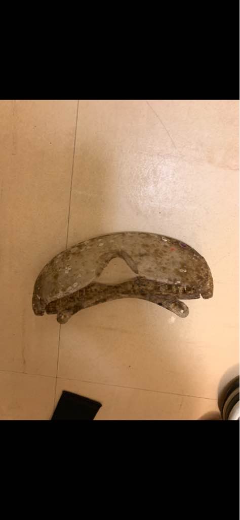
Safety glasses
Tsunami Scuba
Sean Gronset
0
0
0
0
0
0
0
0
0
0
0
0
0
0
0
0
0
0
0
3
0
0
0
0
0
0
0
0
0
0
0
0
0
0
1.00
42
66.00
10.00
0
estimated
0
0
6967.24
0
0
0
0
0
Safety glasses
0
On
pounds
0
I have debris data to report
0
0
0
Slight for waves 0.5 -1.25 meter high
0
0
0
0
0
0
0
m2
0
0
meters
coral reef
0
0
0
0
0
0
0
0
0
0
0
0
0
0
0
0
0
0
0
0
0
0
0
0
0
0
0
0
Japan
State\Province
Okinawa
City
Naha
Map Help


Dive Location

If you know your survey site coordinates, enter them manually in decimal degrees using WGS84 Map Datum. Use the minus sign for latitudes south of the equator and longitudes west of the Prime Meridian to 180 degrees.

If you do not know your survey site coordinates, click the “Map Location” tab to use the map to zoom into your survey site and drop the pin on the map to fall within your survey dive site in the water (not on land or the beach). Ensure you zoom in as much as possible to ensure data accuracy.

Entangled Help


Use the vertical tabs below to record any entangled animals you found of each type.

Southern Links

0
0
0

26.100870575652, 127.74019141164

0
0
0
coral
0
0
0
0
0
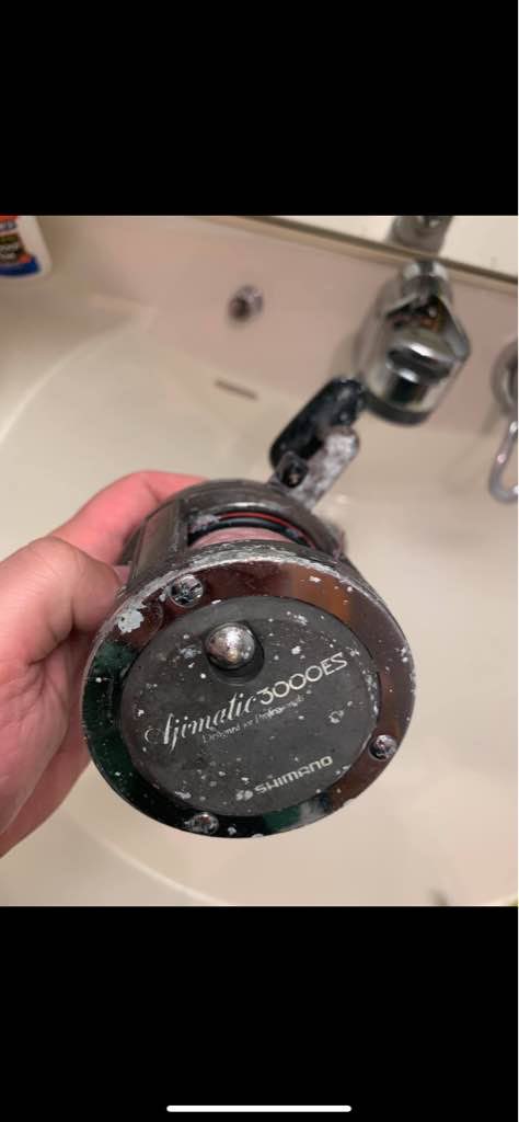
A fishing incident where fisherman dropped his pole
Couldn’t pick up fishing pole would have made dive hazardous
0
0
0
0
0
0
0
0
0
0
0
0
0
0
0
0
0
0
Tsunami Scuba
Sean Gronset
0
0
0
0
0
0
0
0
0
0
0
0
0
0
0
0
0
0
0
2
0
0
0
0
0
0
0
0
0
0
0
0
0
0
3.00
4
130.00
10.00
0
estimated
0
1
1438760.00
0
0
0
0
0
Fishing reel
Fishing line
0
On
pounds
0
I have debris data to report
0
0
0
Slight for waves 0.5 -1.25 meter high
0
0
0
0
0
0
0
m2
0
0
feet
rocky reef
0
0
0
0
0
0
0
0
0
0
0
0
0
0
0
0
0
0
0
0
0
0
0
0
0
0
0
0
Japan
State\Province
Okinawa
City
Naha
Map Help


Dive Location

If you know your survey site coordinates, enter them manually in decimal degrees using WGS84 Map Datum. Use the minus sign for latitudes south of the equator and longitudes west of the Prime Meridian to 180 degrees.

If you do not know your survey site coordinates, click the “Map Location” tab to use the map to zoom into your survey site and drop the pin on the map to fall within your survey dive site in the water (not on land or the beach). Ensure you zoom in as much as possible to ensure data accuracy.
Entangled Help


Use the vertical tabs below to record any entangled animals you found of each type.

Redang Bay Resort Beach

sand
20
5

5.7742188837717, 103.03223681709

Total beach / shallow water till 1m depth cleaning
Total cleaning since begining of diving season
none
tyre
Fine, small wave, less wind
Redang Bay Diving Centre
Naoki A. Sato
20
100
15
20
150.00
60
1.00
0.00
200
estimated
2000.00
On
kilograms
3
I have debris data to report
3
Calm (glassy to rippled) for waves 0 – 0.1 meter high
5
m2
meters
coral reef
10
Malaysia
State\Province
Terengganu
City
Redang
Map Help


Dive Location

If you know your survey site coordinates, enter them manually in decimal degrees using WGS84 Map Datum. Use the minus sign for latitudes south of the equator and longitudes west of the Prime Meridian to 180 degrees.

If you do not know your survey site coordinates, click the “Map Location” tab to use the map to zoom into your survey site and drop the pin on the map to fall within your survey dive site in the water (not on land or the beach). Ensure you zoom in as much as possible to ensure data accuracy.

Entangled Help


Use the vertical tabs below to record any entangled animals you found of each type.

Shallow Turbo

3
5
0

-8.3398777167768, 116.0422729446

3
0
0
sand
0
6
1
20
0
No
Fair
0
0
0
0
0
0
0
0
0
0
0
0
0
0
0
0
0
0
0
0
Trawangan Dive Center
Chelsey
0
1
0
1
0
0
0
0
0
2
0
0
0
0
0
0
0
0
0
5
0
0
0
0
0
0
0
0
0
0
0
0
0
0
6.00
50
18.00
5.00
3
estimated
0
0
2750.24
0
0
0
0
0
Fishing line
Plastic bags
Rope
0
On
kilograms
0
I have debris data to report
1
0
0
Calm (glassy to rippled) for waves 0 – 0.1 meter high
0
0
0
0
0
0
0
m2
0
0
meters
coral reef
0
0
0
0
0
0
0
0
0
0
0
1
0
0
0
0
0
0
0
1
0
0
0
0
0
0
0
0
Indonesia
State\Province
Lombok
City
Gili Trawangan
Map Help


Dive Location

If you know your survey site coordinates, enter them manually in decimal degrees using WGS84 Map Datum. Use the minus sign for latitudes south of the equator and longitudes west of the Prime Meridian to 180 degrees.

If you do not know your survey site coordinates, click the “Map Location” tab to use the map to zoom into your survey site and drop the pin on the map to fall within your survey dive site in the water (not on land or the beach). Ensure you zoom in as much as possible to ensure data accuracy.

Entangled Help


Use the vertical tabs below to record any entangled animals you found of each type.

ADS490 - Namae Beach

4
25
1
rock
2
2
1
7

37.938828884319, 128.78910899162

2
plastic gloves
Oceankind / Namae Scuba Resort
Yongkyu Kim
1
8
2
4
2
1
5.00
40
6.00
2.00
3
estimated
16
1500.00
1
On
kilograms
I have debris data to report
1
Calm (glassy to rippled) for waves 0 – 0.1 meter high
2
1
m2
meters
rocky reef
2
1
2
South Korea
State\Province
Gangwon-do
City
Yangyang
Map Help


Dive Location

If you know your survey site coordinates, enter them manually in decimal degrees using WGS84 Map Datum. Use the minus sign for latitudes south of the equator and longitudes west of the Prime Meridian to 180 degrees.

If you do not know your survey site coordinates, click the “Map Location” tab to use the map to zoom into your survey site and drop the pin on the map to fall within your survey dive site in the water (not on land or the beach). Ensure you zoom in as much as possible to ensure data accuracy.

Entangled Help


Use the vertical tabs below to record any entangled animals you found of each type.

Polo Beach

1
3
0

20.675143652443, -156.4439377338

0
0
0
sand
0
0
0
3
0
No
Tourists being inconsiderate at Fairmont
Hotel should be told to use different beverage containers
Nice pair of prescription glasses
Typical
1
0
0
0
0
0
0
0
0
0
0
0
0
0
0
0
0
0
0
0
Prescription Eyeglasses
Maui Dreams
Weitzenhoffer
0
0
0
6
0
0
0
0
0
0
0
0
0
0
0
1
0
0
0
4
0
0
0
0
0
0
0
0
0
0
0
0
0
0
3.00
70
15.00
4.00
0
estimated
0
2
43476.80
0
0
0
0
0
Clear plastic cups
Degraded clear plastic cups
0
On
kilograms
0
I have debris data to report
0
0
0
Slight for waves 0.5 -1.25 meter high
0
0
0
0
0
0
0
ft2
0
0
meters
coral reef
0
0
0
0
0
0
0
0
0
0
0
0
0
0
0
0
0
0
0
0
0
0
0
0
0
0
0
0
United States
State\Province
HI
City
Wailea
Map Help


Dive Location

If you know your survey site coordinates, enter them manually in decimal degrees using WGS84 Map Datum. Use the minus sign for latitudes south of the equator and longitudes west of the Prime Meridian to 180 degrees.

If you do not know your survey site coordinates, click the “Map Location” tab to use the map to zoom into your survey site and drop the pin on the map to fall within your survey dive site in the water (not on land or the beach). Ensure you zoom in as much as possible to ensure data accuracy.

Entangled Help


Use the vertical tabs below to record any entangled animals you found of each type.

Alligator

0
0
0
0

24.850961, -80.616993

0
0
0
coral
0
0
0
0
0
Unsure
Wood ladder
Windy
Key Dives / FKNMS
Cortney Benson
0
0
0
0
0
0
0
0
0
0
0
0
0
0
0
0
0
0
0
4
0
0
0
0
0
0
0
0
0
0
0
0
0
0
0
0
120.00
45
30.00
25.00
0
measured
0
0
0
0
20.00
0
0
0
0
0
Boat debris
0
On
pounds
0
I have debris data to report
0
0
1
Slight for waves 0.5 -1.25 meter high
0
0
0
0
0
0
0
ft2
0
0
feet
coral reef
0
0
0
0
0
0
0
0
0
0
0
0
0
0
0
0
0
0
0
0
0
0
0
0
0
0
0
0
0
United States
State\Province
FL
City
Islamorada
Map Help


Dive Location

If you know your survey site coordinates, enter them manually in decimal degrees using WGS84 Map Datum. Use the minus sign for latitudes south of the equator and longitudes west of the Prime Meridian to 180 degrees.

If you do not know your survey site coordinates, click the “Map Location” tab to use the map to zoom into your survey site and drop the pin on the map to fall within your survey dive site in the water (not on land or the beach). Ensure you zoom in as much as possible to ensure data accuracy.

Entangled Help


Use the vertical tabs below to record any entangled animals you found of each type.

ADS501 - The Maze

0
0
0
0

24.889917, -80.566383

0
0
0
coral
0
0
0
0
0
Commercial fishing
Windy
Key Dives / FKNMS
Cortney Benson
0
0
0
0
0
0
0
0
0
0
0
0
0
0
0
0
0
0
0
2
0
0
0
0
0
0
0
0
0
0
0
0
0
0
0
0
80.00
45
30.00
18.00
0
measured
0
1
0
0
25.00
0
0
0
0
0
Lobster trap and line
0
On
pounds
0
I have debris data to report
0
0
0
Slight for waves 0.5 -1.25 meter high
0
0
0
0
0
0
0
m2
4
0
feet
coral reef
0
0
0
0
0
0
0
0
0
0
0
0
0
0
0
0
0
0
0
0
0
0
0
0
0
0
0
0
0
United States
State\Province
FL
City
Islamorada
Map Help


Dive Location

If you know your survey site coordinates, enter them manually in decimal degrees using WGS84 Map Datum. Use the minus sign for latitudes south of the equator and longitudes west of the Prime Meridian to 180 degrees.

If you do not know your survey site coordinates, click the “Map Location” tab to use the map to zoom into your survey site and drop the pin on the map to fall within your survey dive site in the water (not on land or the beach). Ensure you zoom in as much as possible to ensure data accuracy.

Entangled Help


Use the vertical tabs below to record any entangled animals you found of each type.

Gota Abu Ramada

0
0
0
0

27.165208, 33.983662

0
0
0
coral
0
0
0
1
0
Normal
The Fifth Point
Nic Emery
0
0
0
0
0
0
0
0
0
0
0
0
0
0
0
0
0
0
0
2
0
0
0
0
0
0
0
0
0
0
0
0
0
0
0
0
0.10
65
12.00
3.00
0
estimated
0
0
0
0
2492.90
0
0
0
0
0
0
On
kilograms
0
I have debris data to report
0
0
0
Smooth (wavelets) for waves 0.1 - 0.5 meter high
0
0
0
0
0
0
0
m2
0
0
meters
coral reef
0
0
0
0
0
0
0
0
0
0
0
0
0
0
0
0
0
0
0
0
0
0
0
0
0
0
0
0
0
Egypt
City
Hurghada
Map Help


Dive Location

If you know your survey site coordinates, enter them manually in decimal degrees using WGS84 Map Datum. Use the minus sign for latitudes south of the equator and longitudes west of the Prime Meridian to 180 degrees.

If you do not know your survey site coordinates, click the “Map Location” tab to use the map to zoom into your survey site and drop the pin on the map to fall within your survey dive site in the water (not on land or the beach). Ensure you zoom in as much as possible to ensure data accuracy.

Entangled Help


Use the vertical tabs below to record any entangled animals you found of each type.

Shallow Turbo

0
5
1

-8.3428266015259, 116.04262203067

0
0
0
coral
0
2
0
20
0
Fishing
Underwear
Fair
1
1
0
0
0
0
0
0
0
0
0
0
0
0
0
0
0
0
0
0
Shovel
Stanley Knife
Trawangan Dive Center
Georgie
0
0
0
0
0
0
0
0
0
1
0
0
0
0
3
0
0
0
0
8
0
0
0
0
0
0
1
0
0
0
0
0
1
0
25.00
65
24.00
5.00
4
estimated
0
15
8839.34
0
0
0
0
0
Fishing lines
Fishing nets
Plastic
0
On
kilograms
0
I have debris data to report
2
0
0
Calm (glassy to rippled) for waves 0 – 0.1 meter high
0
0
0
0
1
0
0
m2
0
0
meters
coral reef
3
0
1
0
0
1
0
0
0
0
0
0
4
0
1
0
0
0
0
0
0
0
0
1
0
0
0
0
Indonesia
State\Province
Lombok
City
Gili Trawangan
Map Help


Dive Location

If you know your survey site coordinates, enter them manually in decimal degrees using WGS84 Map Datum. Use the minus sign for latitudes south of the equator and longitudes west of the Prime Meridian to 180 degrees.

If you do not know your survey site coordinates, click the “Map Location” tab to use the map to zoom into your survey site and drop the pin on the map to fall within your survey dive site in the water (not on land or the beach). Ensure you zoom in as much as possible to ensure data accuracy.

Entangled Help


Use the vertical tabs below to record any entangled animals you found of each type.

Subscribe to