Menu

ADS538 - Outhouse Beach

1
1
0

13.464173460775, 144.65509258277

3
0
0
coral
0
0
0
11
0
No
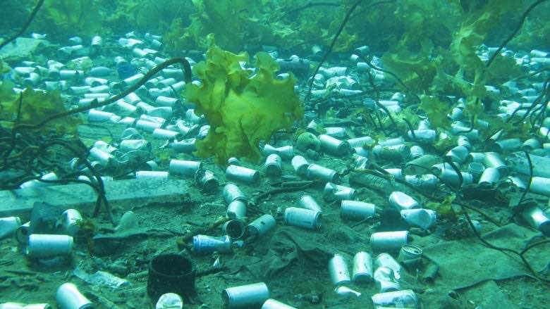
40mm shell casing
1
0
0
0
0
0
0
0
0
0
0
0
0
0
0
0
0
0
0
0
40mm shell casings
Jake Sullivan
0
0
0
0
0
0
0
0
1
0
0
0
0
0
0
1
0
0
0
1
0
0
0
0
0
1
0
0
0
0
0
0
0
0
10.00
60
12.00
2.00
0
estimated
0
10
5000.00
0
0
0
0
0
Glass bottles
Aluminum cans
0
On
kilograms
0
I have debris data to report
14
0
0
Smooth (wavelets) for waves 0.1 - 0.5 meter high
0
0
0
0
0
0
0
ft2
0
0
meters
rocky reef
2
0
0
0
0
0
0
0
0
0
0
0
0
0
0
0
9
0
0
0
0
4
0
0
0
0
1
0
United States
Map Help


Dive Location

If you know your survey site coordinates, enter them manually in decimal degrees using WGS84 Map Datum. Use the minus sign for latitudes south of the equator and longitudes west of the Prime Meridian to 180 degrees.

If you do not know your survey site coordinates, click the “Map Location” tab to use the map to zoom into your survey site and drop the pin on the map to fall within your survey dive site in the water (not on land or the beach). Ensure you zoom in as much as possible to ensure data accuracy.

Entangled Help


Use the vertical tabs below to record any entangled animals you found of each type.

Created 4th March

0
0
0
0

51.483593, -3.190813

0
0
0
sand
0
0
0
0
0
Te
Test
Gino
0
0
0
0
0
0
0
0
0
0
0
0
0
0
0
0
0
0
0
1
0
0
0
0
0
0
0
0
0
0
0
0
0
0
0
0
0.00
60
30.00
20.00
0
measured
0
0
0
0
2207.06
0
0
0
0
0
0
On
kilograms
0
Our Survey Site was free of debris
0
0
0
Calm (glassy to rippled) for waves 0 – 0.1 meter high
0
0
0
0
0
0
0
m2
0
0
meters
coral reef
0
0
0
0
0
0
0
0
0
0
0
0
0
0
0
0
0
0
0
0
0
0
0
0
0
0
0
0
0
Andorra
Map Help


Dive Location

If you know your survey site coordinates, enter them manually in decimal degrees using WGS84 Map Datum. Use the minus sign for latitudes south of the equator and longitudes west of the Prime Meridian to 180 degrees.

If you do not know your survey site coordinates, click the “Map Location” tab to use the map to zoom into your survey site and drop the pin on the map to fall within your survey dive site in the water (not on land or the beach). Ensure you zoom in as much as possible to ensure data accuracy.

Entangled Help


Use the vertical tabs below to record any entangled animals you found of each type.

Together with Ranger to clean up underwater waste at T-dock

14
4

7.352112, 134.478698

silt

7.3520742943409, 134.47877737083

good weather
Palau Ocean Divers/Tony
Tony Tang
3
8
4
1000.00
480
9.00
1.00
estimated
100.00
18
20
On
kilograms
I have debris data to report
Calm (glassy to rippled) for waves 0 – 0.1 meter high m2
meters
coral reef
5
3
2
15
Palau
State\Province
KOROR
City
KOROR
Map Help


Dive Location

If you know your survey site coordinates, enter them manually in decimal degrees using WGS84 Map Datum. Use the minus sign for latitudes south of the equator and longitudes west of the Prime Meridian to 180 degrees.

If you do not know your survey site coordinates, click the “Map Location” tab to use the map to zoom into your survey site and drop the pin on the map to fall within your survey dive site in the water (not on land or the beach). Ensure you zoom in as much as possible to ensure data accuracy.

Entangled Help


Use the vertical tabs below to record any entangled animals you found of each type.

Medalaii Waiting House

9
5
coral
30
20

7.3414274674696, 134.46238263815

This is a supplement, because the previous Palau network is not good, so resubmit. Garbage has been disposed of properly
Palau Ocean DIvers/Tony
Tony Tang
8
1
6
10
5
1
3
5
3
30.00
39
8.00
6.00
estimated
4
100.00
2
1
7
4
6
On
kilograms
I have debris data to report
9
2
Calm (glassy to rippled) for waves 0 – 0.1 meter high
4
m2
8
meters
coral reef
3
1
10
3
1
15
1
Palau
State\Province
koror
City
koror
Map Help


Dive Location

If you know your survey site coordinates, enter them manually in decimal degrees using WGS84 Map Datum. Use the minus sign for latitudes south of the equator and longitudes west of the Prime Meridian to 180 degrees.

If you do not know your survey site coordinates, click the “Map Location” tab to use the map to zoom into your survey site and drop the pin on the map to fall within your survey dive site in the water (not on land or the beach). Ensure you zoom in as much as possible to ensure data accuracy.
Entangled Help


Use the vertical tabs below to record any entangled animals you found of each type.

ADS352 - Meno Slope

1
1
1
0

-8.35026, 116.0511

0
0
0
coral
0
0
0
1
0
Rainy
3
Laundry Wrapper
Gili Shark Conservation
Katon
0
0
0
0
0
0
0
0
0
0
0
0
0
0
0
0
0
0
0
4
1
0
0
0
1
0
0
0
0
0
0
0
0
0
0
0
1.00
48
25.00
17.00
0
estimated
0
0
0
0
8521.17
0
0
0
0
0
0
On
kilograms
0
I have debris data to report
0
0
0
Calm (glassy to rippled) for waves 0 – 0.1 meter high
2
0
0
0
0
0
0
m2
0
0
meters
coral reef
0
0
0
0
0
0
0
0
0
0
0
0
0
0
0
0
0
0
0
0
0
0
0
0
0
0
0
1
0
Indonesia
State\Province
Lombok
City
Gili Meno
Map Help


Dive Location

If you know your survey site coordinates, enter them manually in decimal degrees using WGS84 Map Datum. Use the minus sign for latitudes south of the equator and longitudes west of the Prime Meridian to 180 degrees.

If you do not know your survey site coordinates, click the “Map Location” tab to use the map to zoom into your survey site and drop the pin on the map to fall within your survey dive site in the water (not on land or the beach). Ensure you zoom in as much as possible to ensure data accuracy.

Entangled Help


Use the vertical tabs below to record any entangled animals you found of each type.

ADS607 - Lake Perris

0
0
0
0

33.860804, -117.191911

0
0
0
silt
0
2
0
0
0
Campers
Cloth
Calm 60f
Get Wet Scuba
Cindy
0
0
0
0
0
0
0
0
0
0
0
0
0
0
0
0
0
11
0
5
0
0
0
0
0
0
0
0
0
1
0
0
0
0
0
0
0.50
30
25.00
5.00
0
estimated
0
0
0
0
2272.79
0
0
0
0
0
Plastic
0
On
pounds
0
I have debris data to report
1
0
0
Calm (glassy to rippled) for waves 0 – 0.1 meter high
0
0
0
0
0
0
0
m2
0
3
feet
other
0
0
0
0
0
0
0
0
0
0
0
0
0
0
0
0
0
0
0
0
0
0
0
0
0
0
0
0
0
United States
State\Province
Ca
City
Perris
Map Help


Dive Location

If you know your survey site coordinates, enter them manually in decimal degrees using WGS84 Map Datum. Use the minus sign for latitudes south of the equator and longitudes west of the Prime Meridian to 180 degrees.

If you do not know your survey site coordinates, click the “Map Location” tab to use the map to zoom into your survey site and drop the pin on the map to fall within your survey dive site in the water (not on land or the beach). Ensure you zoom in as much as possible to ensure data accuracy.

Entangled Help


Use the vertical tabs below to record any entangled animals you found of each type.

Qaroough Island

0
0
0

29.025273731139, 48.170643139362

0
0
0
sand
0
1
1
0
0
People awareness especially with kids
No
Irresponsible actions from people
Vehicle tires
Biohazard debris
Good, sunny
0
0
0
0
0
0
0
0
0
0
0
0
0
0
0
0
0
0
0
0
Nautlis
Fatma
1
0
1
0
0
1
0
0
0
1
0
0
0
0
0
0
0
0
0
4
0
0
1
0
1
1
1
1
1
1
1
0
0
0
4.00
30
20.00
18.00
0
estimated
0
0
3330080.00
0
1
1
1
1
Metal cans
Fish nets
Metal nets
1
On
kilograms
0
I have debris data to report
0
0
0
Calm (glassy to rippled) for waves 0 – 0.1 meter high
0
1
0
Dead
Zubaidi
1
Dead
1
0
0
1
m2
1
1
meters
coral reef
0
0
0
0
0
0
0
0
0
0
1
0
0
0
0
0
0
0
0
0
0
0
0
0
0
0
0
0
Afghanistan
State\Province
Kuwait
City
Ahmadi
Map Help


Dive Location

If you know your survey site coordinates, enter them manually in decimal degrees using WGS84 Map Datum. Use the minus sign for latitudes south of the equator and longitudes west of the Prime Meridian to 180 degrees.

If you do not know your survey site coordinates, click the “Map Location” tab to use the map to zoom into your survey site and drop the pin on the map to fall within your survey dive site in the water (not on land or the beach). Ensure you zoom in as much as possible to ensure data accuracy.

Entangled Help


Use the vertical tabs below to record any entangled animals you found of each type.

Created: 3rd March 2020

51.483552383225, -3.1908287081659

sand
James
1
0.00
20
40.00
20.00
measured
100.00
On
kilograms
Our Survey Site was free of debris
Calm (glassy to rippled) for waves 0 – 0.1 meter high m2
meters
coral reef
Afghanistan
Map Help


Dive Location

If you know your survey site coordinates, enter them manually in decimal degrees using WGS84 Map Datum. Use the minus sign for latitudes south of the equator and longitudes west of the Prime Meridian to 180 degrees.

If you do not know your survey site coordinates, click the “Map Location” tab to use the map to zoom into your survey site and drop the pin on the map to fall within your survey dive site in the water (not on land or the beach). Ensure you zoom in as much as possible to ensure data accuracy.

Entangled Help


Use the vertical tabs below to record any entangled animals you found of each type.

Saipan Gurutto

1
coral

15.259039223278, 145.82378565564

none
It is a clean place where divers come and go.
We could see glass bottles.
none
Warm and windy good weather
Take's skinscuba
JUSUNG KWAK
1
1
15
6.00
20
16.00
4.00
estimated
460.00
metal fragments
cans
On
kilograms
Our Survey Site was free of debris
2
1
Slight for waves 0.5 -1.25 meter high m2
meters
coral reef
3
2
1
Northern Mariana Islands
City
Gwang ju
Map Help


Dive Location

If you know your survey site coordinates, enter them manually in decimal degrees using WGS84 Map Datum. Use the minus sign for latitudes south of the equator and longitudes west of the Prime Meridian to 180 degrees.

If you do not know your survey site coordinates, click the “Map Location” tab to use the map to zoom into your survey site and drop the pin on the map to fall within your survey dive site in the water (not on land or the beach). Ensure you zoom in as much as possible to ensure data accuracy.

Entangled Help


Use the vertical tabs below to record any entangled animals you found of each type.

Clownfish

0
0
0

-23.850302303427, 35.545315362831

0
0
0
sand
0
1
0
0
0
Windy, lot of surge
0
0
0
0
0
0
0
0
0
0
0
0
0
0
0
0
0
0
0
0
Liquid Dive Adventures
Satu
0
0
0
0
0
0
0
0
0
0
0
0
0
0
0
0
0
0
0
2
0
0
0
0
0
0
0
0
0
0
0
0
0
0
0.10
45
11.00
8.00
0
estimated
0
0
3265.31
0
0
0
0
0
0
On
kilograms
0
I have debris data to report
0
0
0
Moderate to rough for waves greater than 1.25 meters
0
0
0
0
0
0
0
m2
0
0
meters
coral reef
0
0
0
0
0
0
0
0
0
0
0
0
0
0
0
0
0
0
0
0
0
0
0
0
0
0
0
0
Mozambique
State\Province
Inhambane
City
Tofo
Map Help


Dive Location

If you know your survey site coordinates, enter them manually in decimal degrees using WGS84 Map Datum. Use the minus sign for latitudes south of the equator and longitudes west of the Prime Meridian to 180 degrees.

If you do not know your survey site coordinates, click the “Map Location” tab to use the map to zoom into your survey site and drop the pin on the map to fall within your survey dive site in the water (not on land or the beach). Ensure you zoom in as much as possible to ensure data accuracy.

Entangled Help


Use the vertical tabs below to record any entangled animals you found of each type.

Subscribe to