Menu

ADS116 - Tunnelen

67.234674, 14.604692

16
rock
10
Saltstraumen DykkeCamp
Fredric Ihrsen
1
2.60
67
27.00
5.00
measured
42
2500.00
On
kilograms
I have debris data to report
Smooth (wavelets) for waves 0.1 - 0.5 meter high m2
meters
kelp
Norway
Map Help


Dive Location

If you know your survey site coordinates, enter them manually in decimal degrees using WGS84 Map Datum. Use the minus sign for latitudes south of the equator and longitudes west of the Prime Meridian to 180 degrees.

If you do not know your survey site coordinates, click the “Map Location” tab to use the map to zoom into your survey site and drop the pin on the map to fall within your survey dive site in the water (not on land or the beach). Ensure you zoom in as much as possible to ensure data accuracy.

Entangled Help


Use the vertical tabs below to record any entangled animals you found of each type.

Ersvika

67.282847, 14.729083

1
rock
1
Saltstraumen DykkeCamp
Fredric Ihrsen
2
2
0.40
39
18.00
1.00
measured
4
1500.00
On
kilograms
I have debris data to report
Calm (glassy to rippled) for waves 0 – 0.1 meter high m2
meters
kelp
Norway
Map Help


Dive Location

If you know your survey site coordinates, enter them manually in decimal degrees using WGS84 Map Datum. Use the minus sign for latitudes south of the equator and longitudes west of the Prime Meridian to 180 degrees.

If you do not know your survey site coordinates, click the “Map Location” tab to use the map to zoom into your survey site and drop the pin on the map to fall within your survey dive site in the water (not on land or the beach). Ensure you zoom in as much as possible to ensure data accuracy.
Entangled Help


Use the vertical tabs below to record any entangled animals you found of each type.

ADS619 - Crossroads Lagoon

1
8

4.1221944444444, 73.467138888889

sand
1
1
BUILDING CONSTRUCTION, DEBRIS SINKING AFTER FLOATING, lost items from Guests
ENGINE PART
3
1
1
2
1
RUBBER CABLE
ENGINE PART
WATER TAPE
SAND BAG
brush
BEST DIVES MALDIVES
CATERINA
1
1
2
1
7
4
1
1
5.00
25
4.00
0.50
estimated
30.00
3
4
On
kilograms
I have debris data to report
1
Calm (glassy to rippled) for waves 0 – 0.1 meter high
3
2
3
m2
meters
other
1
6
1
Maldives
State\Province
MALDIVES KAAFU ATOLL
City
male
Map Help


Dive Location

If you know your survey site coordinates, enter them manually in decimal degrees using WGS84 Map Datum. Use the minus sign for latitudes south of the equator and longitudes west of the Prime Meridian to 180 degrees.

If you do not know your survey site coordinates, click the “Map Location” tab to use the map to zoom into your survey site and drop the pin on the map to fall within your survey dive site in the water (not on land or the beach). Ensure you zoom in as much as possible to ensure data accuracy.
Entangled Help


Use the vertical tabs below to record any entangled animals you found of each type.

Ecosystem Other
SANDY LAGOON

Balanciais

0
0
1
2

36.921, -8.1597

0
0
0
rock
0
0
0
0
0
Cloudy
Easydivers
António Da Silva
0
0
0
0
0
0
0
0
0
0
0
0
0
0
0
0
0
0
0
2
0
0
0
0
0
0
0
0
0
0
0
0
0
0
0
0
3.20
30
20.00
18.00
0
measured
0
0
0
0
25.00
0
0
0
0
0
Ghost nets
0
On
kilograms
0
I have debris data to report
0
0
0
Calm (glassy to rippled) for waves 0 – 0.1 meter high
0
0
0
0
0
0
0
m2
0
0
meters
rocky reef
1
0
0
0
0
0
0
0
0
0
0
0
0
0
0
0
0
0
0
0
0
0
0
0
0
0
0
0
0
Portugal
State\Province
Faro
City
Albufeira
Map Help


Dive Location

If you know your survey site coordinates, enter them manually in decimal degrees using WGS84 Map Datum. Use the minus sign for latitudes south of the equator and longitudes west of the Prime Meridian to 180 degrees.

If you do not know your survey site coordinates, click the “Map Location” tab to use the map to zoom into your survey site and drop the pin on the map to fall within your survey dive site in the water (not on land or the beach). Ensure you zoom in as much as possible to ensure data accuracy.
Entangled Help


Use the vertical tabs below to record any entangled animals you found of each type.

ADS323 - Tung Ping Chau

13
8
3

22.5459, 114.431823

0
0
0
sand
0
11
0
1
0
Windy but sunny
1
0
0
0
0
0
0
0
0
0
0
0
0
0
0
0
0
0
0
0
Flower pot
Tursiopsdivers
Eszter
0
0
0
0
0
0
0
0
0
0
4
0
0
2
1
0
0
0
0
12
0
0
0
0
0
0
0
0
0
0
0
0
0
0
9.43
24
5.90
1.20
0
measured
0
0
2802.46
0
0
0
0
0
0
On
kilograms
0
I have debris data to report
1
0
0
Smooth (wavelets) for waves 0.1 - 0.5 meter high
2
0
1
0
0
0
0
m2
10
0
meters
coral reef
1
0
1
0
0
2
0
0
0
0
0
0
0
0
0
0
3
0
0
0
0
1
0
0
0
0
0
0
Hong Kong S.A.R., China
Map Help


Dive Location

If you know your survey site coordinates, enter them manually in decimal degrees using WGS84 Map Datum. Use the minus sign for latitudes south of the equator and longitudes west of the Prime Meridian to 180 degrees.

If you do not know your survey site coordinates, click the “Map Location” tab to use the map to zoom into your survey site and drop the pin on the map to fall within your survey dive site in the water (not on land or the beach). Ensure you zoom in as much as possible to ensure data accuracy.

Entangled Help


Use the vertical tabs below to record any entangled animals you found of each type.

ADS323 - Tung Ping Chau

32
41
9

22.545909, 114.431823

2
0
0
sand
1
7
0
3
0
Windy and sunny
5
1
1
3
1
0
0
0
0
0
0
0
0
0
0
0
0
0
0
0
Tarp bags
Wheel (trolley)
Pen
Fiberglass fragment
Chair cushion
Tursiopsdivers
Eszter
0
1
0
5
0
0
0
0
0
0
0
0
1
7
0
0
0
2
1
13
0
0
2
0
3
0
0
0
0
0
0
0
0
0
17.62
42
6.20
1.20
5
measured
0
0
12858.00
1
0
1
0
0
Plastic bags wraps and bags
Abandoned fishing gears
Beverage cans
1
On
kilograms
0
I have debris data to report
5
0
0
Smooth (wavelets) for waves 0.1 - 0.5 meter high
0
0
2
0
2
1
0
m2
0
0
meters
coral reef
0
0
0
0
0
2
0
0
0
0
0
0
0
0
0
0
9
0
0
3
0
0
0
0
0
0
1
0
Hong Kong S.A.R., China
Map Help


Dive Location

If you know your survey site coordinates, enter them manually in decimal degrees using WGS84 Map Datum. Use the minus sign for latitudes south of the equator and longitudes west of the Prime Meridian to 180 degrees.

If you do not know your survey site coordinates, click the “Map Location” tab to use the map to zoom into your survey site and drop the pin on the map to fall within your survey dive site in the water (not on land or the beach). Ensure you zoom in as much as possible to ensure data accuracy.

Entangled Help


Use the vertical tabs below to record any entangled animals you found of each type.

Vagaru House Reef

2

6.088, 73.204333333333

coral
6
windy in the morning and calm in the afternoon. few showers
Best Dives Maldives Vagaru
Giulia
1
1
3
1
1
58.00
45
28.00
6.00
estimated
30.00
6
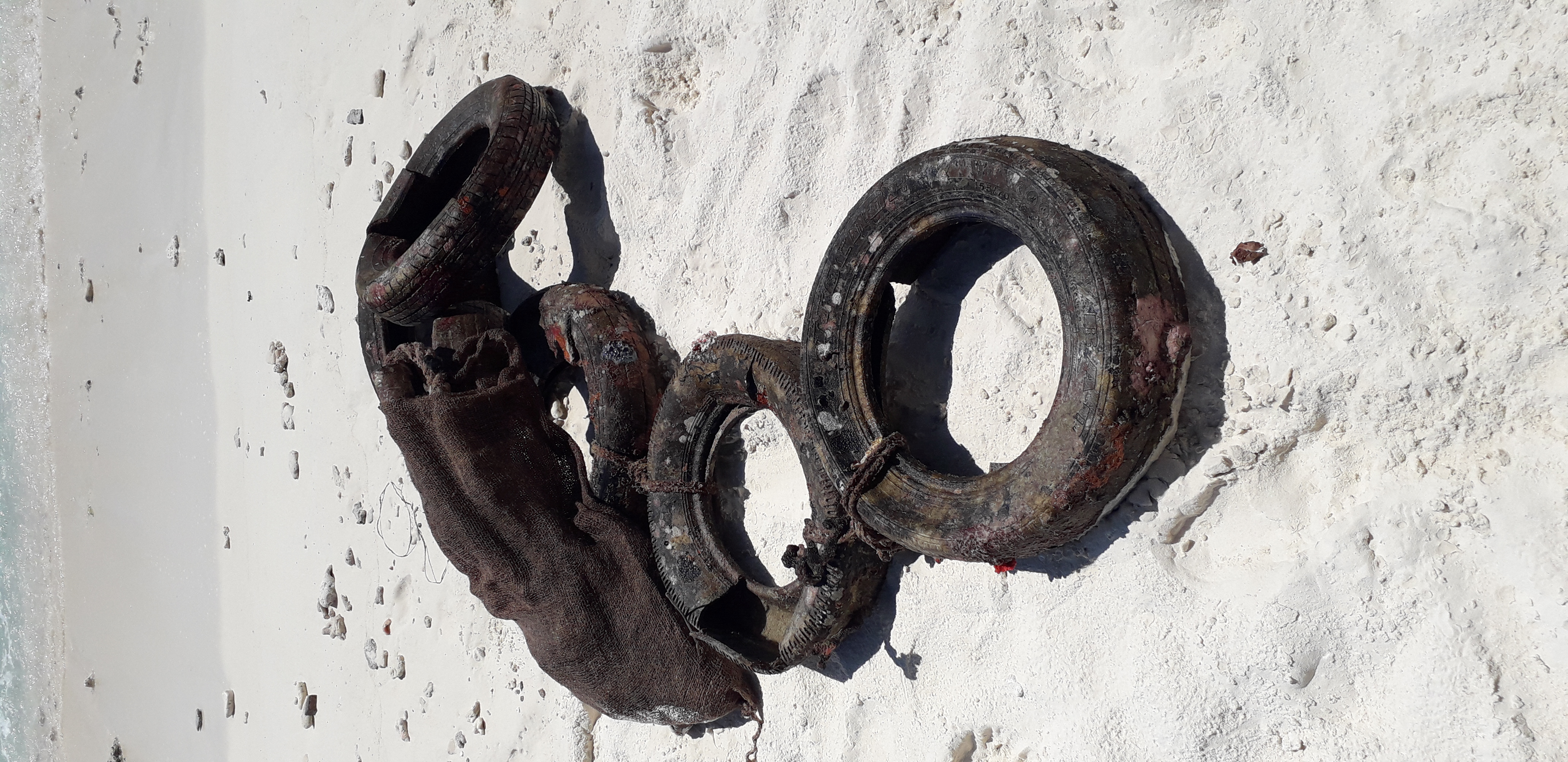
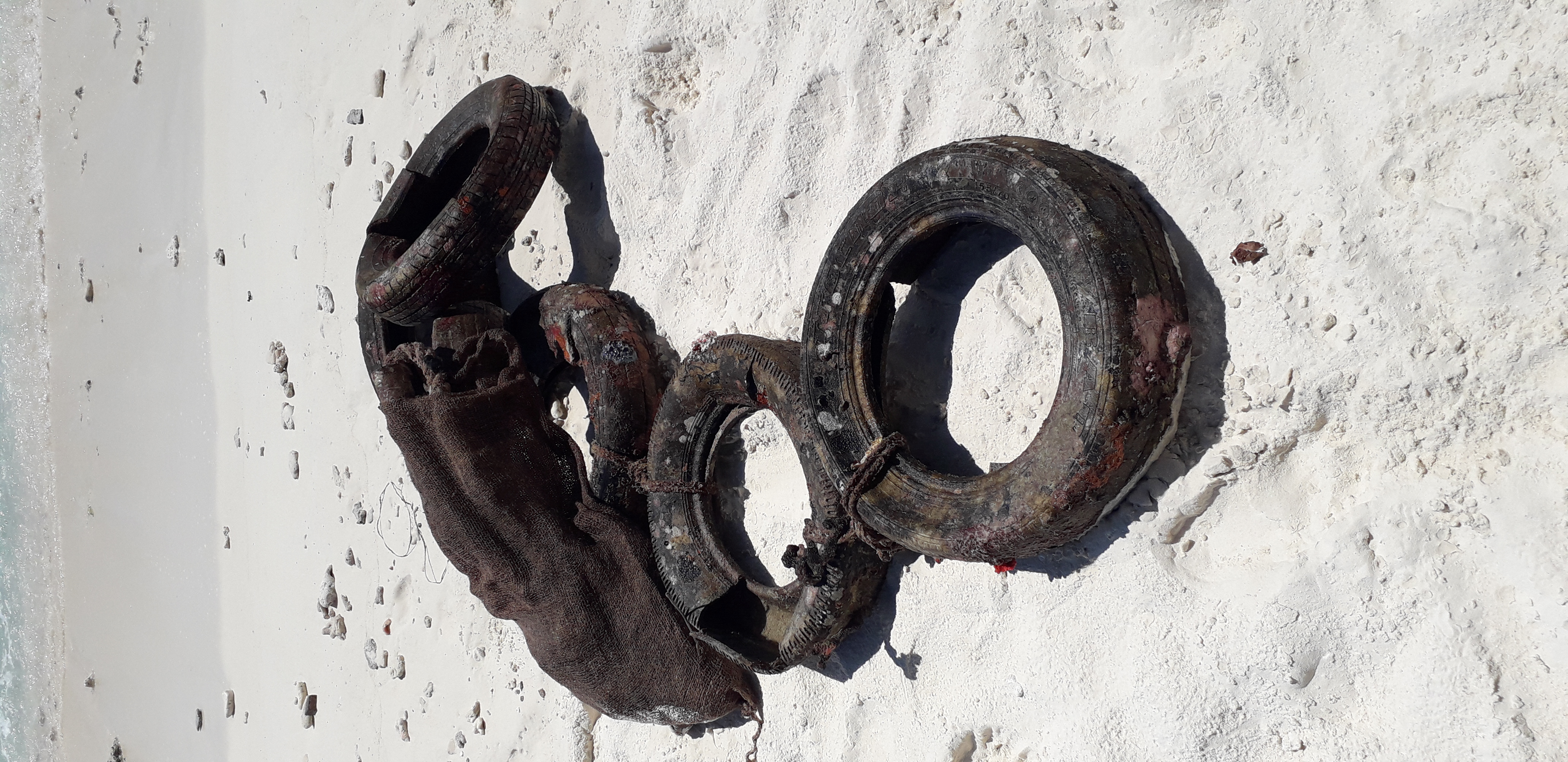
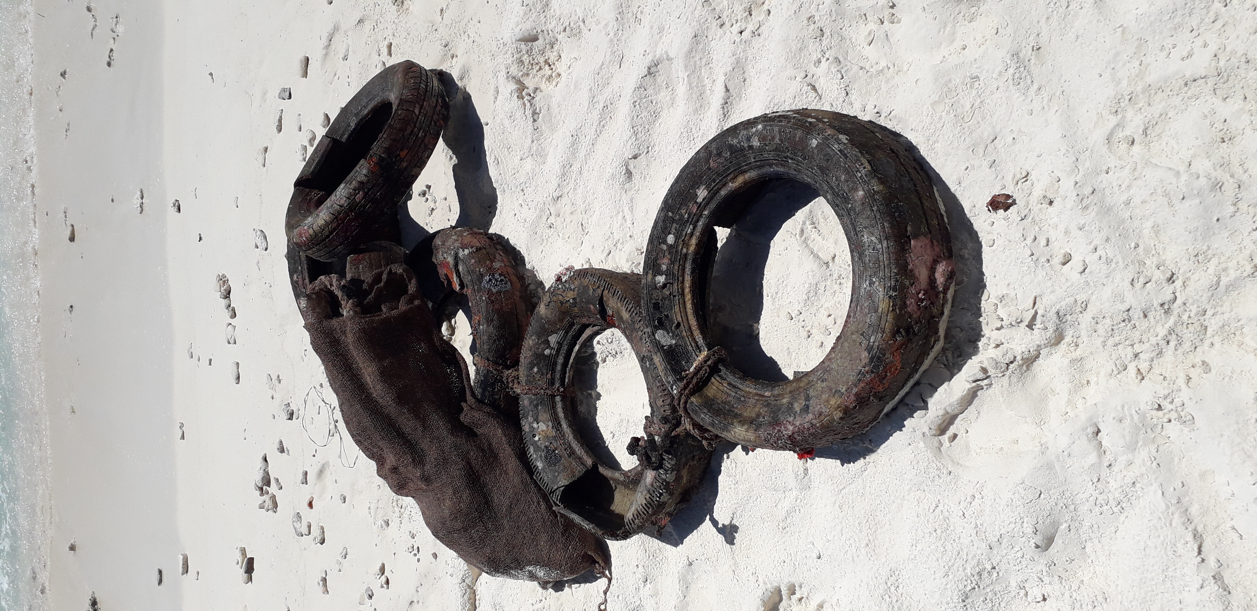
tyres
plastic bags
fishing lines
On
kilograms
I have debris data to report
Slight for waves 0.5 -1.25 meter high m2
meters
coral reef
Maldives
State\Province
Shaviyani Atoll
City
vagaru
Map Help


Dive Location

If you know your survey site coordinates, enter them manually in decimal degrees using WGS84 Map Datum. Use the minus sign for latitudes south of the equator and longitudes west of the Prime Meridian to 180 degrees.

If you do not know your survey site coordinates, click the “Map Location” tab to use the map to zoom into your survey site and drop the pin on the map to fall within your survey dive site in the water (not on land or the beach). Ensure you zoom in as much as possible to ensure data accuracy.

Entangled Help


Use the vertical tabs below to record any entangled animals you found of each type.

ADS618 - Vagaru House Reef

2

6.088, 73.204333333333

coral
6
windy in the morning and calm in the afternoon. few showers
Best Dives Maldives Vagaru
Giulia
1
1
3
1
1
58.00
45
28.00
6.00
estimated
30.00
6
tyres
plastic bags
fishing lines
On
kilograms
I have debris data to report
Slight for waves 0.5 -1.25 meter high m2
meters
coral reef
Maldives
State\Province
Shaviyani Atoll
City
vagaru
Map Help


Dive Location

If you know your survey site coordinates, enter them manually in decimal degrees using WGS84 Map Datum. Use the minus sign for latitudes south of the equator and longitudes west of the Prime Meridian to 180 degrees.

If you do not know your survey site coordinates, click the “Map Location” tab to use the map to zoom into your survey site and drop the pin on the map to fall within your survey dive site in the water (not on land or the beach). Ensure you zoom in as much as possible to ensure data accuracy.

Entangled Help


Use the vertical tabs below to record any entangled animals you found of each type.

Vagaru House Reef

6.088, 73.204333333333

coral
10
Weather was very windy in the mornings and very calm in the afternoons. Few showers.
Best Dives Maldives Vagaru
Giulia
1
1
3
1
1
58.00
45
28.00
6.00
estimated
30.00
6
tyres
plastic bags
fishing lines
On
kilograms
I have debris data to report
Slight for waves 0.5 -1.25 meter high m2
meters
coral reef
Maldives
State\Province
Shaviyani Atoll
City
vagaru
Map Help


Dive Location

If you know your survey site coordinates, enter them manually in decimal degrees using WGS84 Map Datum. Use the minus sign for latitudes south of the equator and longitudes west of the Prime Meridian to 180 degrees.

If you do not know your survey site coordinates, click the “Map Location” tab to use the map to zoom into your survey site and drop the pin on the map to fall within your survey dive site in the water (not on land or the beach). Ensure you zoom in as much as possible to ensure data accuracy.

Entangled Help


Use the vertical tabs below to record any entangled animals you found of each type.

The Pinnacle

0
0
0
0

50.681282, -1.947285

0
0
0
sand
0
0
0
0
0
No
N/A
Good.
1
Lanyard and Key
Coast2Coast Scuba
JoJo
0
0
0
0
0
0
0
0
0
0
0
0
0
0
0
0
0
0
0
4
0
0
0
0
0
0
0
0
1
0
0
0
0
0
0
0
11.30
35
19.00
7.00
0
measured
0
0
0
0
4511.99
0
0
0
0
0
0
On
kilograms
0
I have debris data to report
0
0
0
Calm (glassy to rippled) for waves 0 – 0.1 meter high
0
0
0
0
0
0
0
m2
0
0
meters
rocky reef
0
0
0
0
0
0
0
0
0
0
0
0
0
0
0
0
0
1
0
0
0
0
0
0
0
0
0
0
0
United Kingdom
State\Province
Dorset
City
Bournemouth
Map Help


Dive Location

If you know your survey site coordinates, enter them manually in decimal degrees using WGS84 Map Datum. Use the minus sign for latitudes south of the equator and longitudes west of the Prime Meridian to 180 degrees.

If you do not know your survey site coordinates, click the “Map Location” tab to use the map to zoom into your survey site and drop the pin on the map to fall within your survey dive site in the water (not on land or the beach). Ensure you zoom in as much as possible to ensure data accuracy.

Entangled Help


Use the vertical tabs below to record any entangled animals you found of each type.

Subscribe to