Menu

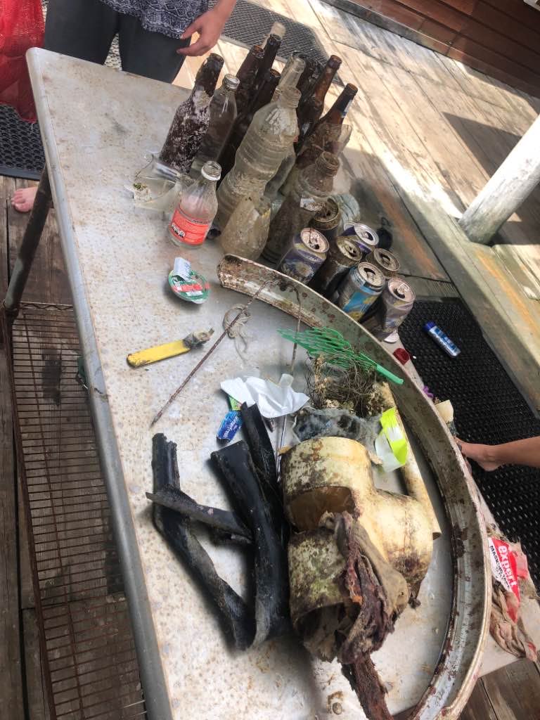
sa su umons dive day clean

rock

33.510077983348, 126.48010847804

sea sky jeju
sun il kim
325201
5.00
35
10.00
3.00
estimated
1578.00
On
kilograms
I have debris data to report
Smooth (wavelets) for waves 0.1 - 0.5 meter high m2
meters
rocky reef
South Korea
City
jejusi
Map Help


Dive Location

If you know your survey site coordinates, enter them manually in decimal degrees using WGS84 Map Datum. Use the minus sign for latitudes south of the equator and longitudes west of the Prime Meridian to 180 degrees.

If you do not know your survey site coordinates, click the “Map Location” tab to use the map to zoom into your survey site and drop the pin on the map to fall within your survey dive site in the water (not on land or the beach). Ensure you zoom in as much as possible to ensure data accuracy.

Entangled Help


Use the vertical tabs below to record any entangled animals you found of each type.

Green Bay Marina

64
10
10
sand
12
2
10

35.288354923082, 139.67295209984

Yes
A lot of bamboo
Super Typhoon and tropical storm.
Yokosuka Bubble Club
Cindy Van Dvyk
-2
32
4
14
3
22
2
105.00
120
10.00
1.00
4
estimated
20.00
Plastic pieces
On
pounds
I have debris data to report
Calm (glassy to rippled) for waves 0 – 0.1 meter high
35
ft2
feet
rocky reef
Japan
State\Province
Kanagawa
City
Yokosuka
Map Help


Dive Location

If you know your survey site coordinates, enter them manually in decimal degrees using WGS84 Map Datum. Use the minus sign for latitudes south of the equator and longitudes west of the Prime Meridian to 180 degrees.

If you do not know your survey site coordinates, click the “Map Location” tab to use the map to zoom into your survey site and drop the pin on the map to fall within your survey dive site in the water (not on land or the beach). Ensure you zoom in as much as possible to ensure data accuracy.

Entangled Help


Use the vertical tabs below to record any entangled animals you found of each type.

Utila Harbour

6
7
0

16.108756, -86.946971

0
0
0
seagrass
0
0
0
1
0
bad vis
life
tire cover
Shit
1
1
1
0
0
0
0
0
0
0
0
0
0
0
0
0
0
0
0
0
bicycle tire cover
sand paper
lever
Bay Islands College of Diving
David and Raf
0
2
0
0
0
0
0
0
0
1
0
0
0
0
0
0
0
1
0
5
0
0
0
0
2
0
0
0
0
0
0
0
0
0
30.00
60
5.00
2.00
0
estimated
0
0
30.00
0
0
1
3
0
fishing line
plastic bags
3
On
pounds
0
I have debris data to report
19
0
0
Smooth (wavelets) for waves 0.1 - 0.5 meter high
0
0
0
0
3
0
0
m2
0
0
meters
seagrass
1
0
0
0
0
1
1
1
0
0
0
0
0
0
0
2
7
0
0
0
0
0
0
0
0
0
0
0
Honduras
City
Utila
Map Help


Dive Location

If you know your survey site coordinates, enter them manually in decimal degrees using WGS84 Map Datum. Use the minus sign for latitudes south of the equator and longitudes west of the Prime Meridian to 180 degrees.

If you do not know your survey site coordinates, click the “Map Location” tab to use the map to zoom into your survey site and drop the pin on the map to fall within your survey dive site in the water (not on land or the beach). Ensure you zoom in as much as possible to ensure data accuracy.

Entangled Help


Use the vertical tabs below to record any entangled animals you found of each type.

26°783025,- 80°0410

2
2
sand
10

26.7830054, -80.0461735

80° sunny, calm
Scuba works
Mike
1
1
1
13
5.00
50
20.00
3.00
estimated
6
200.00
On
pounds
I have debris data to report
Calm (glassy to rippled) for waves 0 – 0.1 meter high
1
ft2
feet
other
United States
State\Province
Florida
City
Jupiter
Map Help


Dive Location

If you know your survey site coordinates, enter them manually in decimal degrees using WGS84 Map Datum. Use the minus sign for latitudes south of the equator and longitudes west of the Prime Meridian to 180 degrees.

If you do not know your survey site coordinates, click the “Map Location” tab to use the map to zoom into your survey site and drop the pin on the map to fall within your survey dive site in the water (not on land or the beach). Ensure you zoom in as much as possible to ensure data accuracy.

Entangled Help


Use the vertical tabs below to record any entangled animals you found of each type.

ADS372 - Cas Abao Beach

0
0
0
0

12.221522, -69.09345

0
0
0
coral
0
0
0
0
0
No
Whipe
Light rain, calm
B Diving And Watersports Curacao
Thomas Kemenes
0
0
0
0
0
0
0
0
0
0
0
0
0
0
0
0
0
0
0
3
0
0
0
0
0
0
0
0
0
0
0
0
0
0
0
0
0.30
67
17.00
3.00
0
estimated
0
0
0
0
1110.20
0
0
0
0
0
Can
0
On
kilograms
0
I have debris data to report
0
0
0
Smooth (wavelets) for waves 0.1 - 0.5 meter high
0
0
0
0
0
0
0
m2
0
1
meters
coral reef
0
0
0
0
0
0
0
0
0
0
0
0
0
0
0
0
0
1
0
0
0
0
0
0
0
0
0
0
0
Netherlands Antilles
State\Province
Curacao
City
Willemstad
Map Help


Dive Location

If you know your survey site coordinates, enter them manually in decimal degrees using WGS84 Map Datum. Use the minus sign for latitudes south of the equator and longitudes west of the Prime Meridian to 180 degrees.

If you do not know your survey site coordinates, click the “Map Location” tab to use the map to zoom into your survey site and drop the pin on the map to fall within your survey dive site in the water (not on land or the beach). Ensure you zoom in as much as possible to ensure data accuracy.

Entangled Help


Use the vertical tabs below to record any entangled animals you found of each type.

Hällebäck

1
0
0

58.346263633768, 11.588258790521

2
0
0
silt
0
0
0
2
0
Windy & rainy
0
0
0
0
0
0
0
0
0
0
0
0
0
0
0
0
0
0
0
0
Oxygene Diving
Andréas
0
0
0
0
0
0
0
0
0
0
0
0
0
0
0
0
0
0
0
3
0
0
0
0
0
0
0
0
0
0
0
0
0
0
1.00
35
15.00
6.00
0
estimated
0
0
10615.20
0
0
0
0
0
0
On
kilograms
0
I have debris data to report
0
0
0
Smooth (wavelets) for waves 0.1 - 0.5 meter high
0
0
0
0
0
0
0
m2
0
0
meters
rocky reef
0
0
0
0
0
0
0
0
0
0
0
0
0
0
0
0
0
0
0
0
0
0
0
0
0
0
0
0
Sweden
City
Hällebäck
Map Help


Dive Location

If you know your survey site coordinates, enter them manually in decimal degrees using WGS84 Map Datum. Use the minus sign for latitudes south of the equator and longitudes west of the Prime Meridian to 180 degrees.

If you do not know your survey site coordinates, click the “Map Location” tab to use the map to zoom into your survey site and drop the pin on the map to fall within your survey dive site in the water (not on land or the beach). Ensure you zoom in as much as possible to ensure data accuracy.

Entangled Help


Use the vertical tabs below to record any entangled animals you found of each type.

ADS499 - Spaans Lagoon

9
38
1

12.470307953115, -69.980066674621

1
0
0
sand
0
77
0
1
82
0
0
0
0
0
0
0
0
0
0
0
0
0
0
0
0
0
0
0
0
Scubblebubbles and ALFI
Nichole Danser
46
5
5
71
0
0
0
0
2
0
0
0
1
5
0
0
0
8
0
12
0
0
5
0
9
1
1
18
2
0
2
0
0
0
30.00
65
5.00
1.00
8
estimated
0
0
80.00
0
1
0
2
1
Lube bottles
0
On
kilograms
0
I have debris data to report
29
0
0
Calm (glassy to rippled) for waves 0 – 0.1 meter high
3
0
19
0
3
2
0
m2
5
1
meters
mangroves
2
0
2
0
0
0
1
0
0
3
0
0
0
0
0
6
25
0
0
0
0
0
0
0
0
1
0
0
Aruba
City
Pos Chiquito
Map Help


Dive Location

If you know your survey site coordinates, enter them manually in decimal degrees using WGS84 Map Datum. Use the minus sign for latitudes south of the equator and longitudes west of the Prime Meridian to 180 degrees.

If you do not know your survey site coordinates, click the “Map Location” tab to use the map to zoom into your survey site and drop the pin on the map to fall within your survey dive site in the water (not on land or the beach). Ensure you zoom in as much as possible to ensure data accuracy.

Entangled Help


Use the vertical tabs below to record any entangled animals you found of each type.

ADS314 - Shark Island

1
0
0

25.353533, 56.376133

0
0
0
coral
0
2
0
0
0
0
0
0
0
0
0
0
0
0
0
0
0
0
0
0
0
0
0
0
0
N/A
Hassan NK Khayal
0
0
0
0
0
0
0
0
1
0
0
0
0
0
0
0
0
0
0
2
0
0
0
0
0
0
0
0
0
0
0
0
0
0
0.10
60
8.00
3.00
0
estimated
0
0
50.00
0
0
0
0
0
0
On
kilograms
0
I have debris data to report
0
0
0
Calm (glassy to rippled) for waves 0 – 0.1 meter high
0
0
0
0
0
0
0
m2
0
0
meters
coral reef
0
0
0
0
0
0
0
0
0
0
0
0
0
0
0
0
0
0
0
0
0
0
0
0
0
0
0
0
United Arab Emirates
Map Help


Dive Location

If you know your survey site coordinates, enter them manually in decimal degrees using WGS84 Map Datum. Use the minus sign for latitudes south of the equator and longitudes west of the Prime Meridian to 180 degrees.

If you do not know your survey site coordinates, click the “Map Location” tab to use the map to zoom into your survey site and drop the pin on the map to fall within your survey dive site in the water (not on land or the beach). Ensure you zoom in as much as possible to ensure data accuracy.

Entangled Help


Use the vertical tabs below to record any entangled animals you found of each type.

ADS268 - Dibba Rock

0
0
0

25.6025977, 56.351134

0
0
0
coral
0
0
0
0
0
0
0
0
0
0
0
0
0
0
0
0
0
0
0
0
0
0
0
0
0
N/A
Hassan NK Khayal
0
0
0
0
0
0
0
0
0
0
0
0
0
0
0
0
0
0
0
2
0
0
0
0
0
0
0
0
0
0
0
0
0
0
0.00
60
14.00
4.00
0
measured
0
0
50.00
0
0
0
0
0
0
On
kilograms
0
Our Survey Site was free of debris
0
0
0
Calm (glassy to rippled) for waves 0 – 0.1 meter high
0
0
0
0
0
0
0
m2
0
0
meters
coral reef
0
0
0
0
0
0
0
0
0
0
0
0
0
0
0
0
0
0
0
0
0
0
0
0
0
0
0
0
United Arab Emirates
Map Help


Dive Location

If you know your survey site coordinates, enter them manually in decimal degrees using WGS84 Map Datum. Use the minus sign for latitudes south of the equator and longitudes west of the Prime Meridian to 180 degrees.

If you do not know your survey site coordinates, click the “Map Location” tab to use the map to zoom into your survey site and drop the pin on the map to fall within your survey dive site in the water (not on land or the beach). Ensure you zoom in as much as possible to ensure data accuracy.

Entangled Help


Use the vertical tabs below to record any entangled animals you found of each type.

ADS518 - Batu Bolong

-8.536846, 119.614061

rock
Calm, no wind, strong current
Azul Unlimited
Sarah Miller
4
0.00
50
25.00
8.00
measured
200.00
On
kilograms
Our Survey Site was free of debris
Smooth (wavelets) for waves 0.1 - 0.5 meter high m2
meters
rocky reef
Indonesia
State\Province
NTT
City
Labuan Bajo
Map Help


Dive Location

If you know your survey site coordinates, enter them manually in decimal degrees using WGS84 Map Datum. Use the minus sign for latitudes south of the equator and longitudes west of the Prime Meridian to 180 degrees.

If you do not know your survey site coordinates, click the “Map Location” tab to use the map to zoom into your survey site and drop the pin on the map to fall within your survey dive site in the water (not on land or the beach). Ensure you zoom in as much as possible to ensure data accuracy.

Entangled Help


Use the vertical tabs below to record any entangled animals you found of each type.

Subscribe to