Menu

Grand Quaie

0
2
0

45.255063997803, -74.204261747754

1
0
0
sand
0
3
0
0
0
Yes !
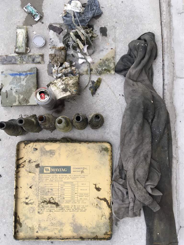
Couvercle de laveuse
Sunny
1
0
0
0
0
0
0
0
0
0
0
0
0
0
0
0
0
0
0
0
Top washer
Eli
0
0
0
0
0
0
0
0
0
0
0
0
0
0
0
0
0
0
0
3
0
0
0
0
1
0
0
0
0
0
0
0
0
0
30.00
120
6.00
2.00
0
estimated
0
0
63179.00
0
0
0
0
0
0
On
pounds
0
I have debris data to report
6
0
0
Smooth (wavelets) for waves 0.1 - 0.5 meter high
1
0
0
0
0
0
0
m2
0
1
feet
seagrass
0
0
0
0
0
1
0
0
0
0
0
0
0
0
0
0
1
0
0
0
0
0
0
0
0
0
0
0
Canada
State\Province
Quebec
City
Les Coteaux
Map Help


Dive Location

If you know your survey site coordinates, enter them manually in decimal degrees using WGS84 Map Datum. Use the minus sign for latitudes south of the equator and longitudes west of the Prime Meridian to 180 degrees.

If you do not know your survey site coordinates, click the “Map Location” tab to use the map to zoom into your survey site and drop the pin on the map to fall within your survey dive site in the water (not on land or the beach). Ensure you zoom in as much as possible to ensure data accuracy.

Entangled Help


Use the vertical tabs below to record any entangled animals you found of each type.

USAT Liberty Wreck

0
0
0

-8.274206, 115.593038

0
0
0
coral
0
0
0
0
0
No
None
Windy, no rain
0
0
0
0
0
0
0
0
0
0
0
0
0
0
0
0
0
0
0
0
Crystal Divers Bali
Soeren Schmidt
0
0
0
0
0
0
0
0
0
0
0
0
0
0
0
0
0
0
0
2
0
0
0
0
0
0
0
0
0
0
0
0
0
0
0.00
51
24.00
3.00
0
estimated
0
0
2125.00
0
0
0
0
0
0
On
kilograms
0
Our Survey Site was free of debris
0
0
0
Slight for waves 0.5 -1.25 meter high
0
0
0
0
0
0
0
m2
0
0
meters
coral reef
0
0
0
0
0
0
0
0
0
0
0
0
0
0
0
0
0
0
0
0
0
0
0
0
0
0
0
0
Indonesia
State\Province
Bali
City
Tulamben
Map Help


Dive Location

If you know your survey site coordinates, enter them manually in decimal degrees using WGS84 Map Datum. Use the minus sign for latitudes south of the equator and longitudes west of the Prime Meridian to 180 degrees.

If you do not know your survey site coordinates, click the “Map Location” tab to use the map to zoom into your survey site and drop the pin on the map to fall within your survey dive site in the water (not on land or the beach). Ensure you zoom in as much as possible to ensure data accuracy.
Entangled Help


Use the vertical tabs below to record any entangled animals you found of each type.

TDC

0
6
0
0

-8.349074, 116.043745

0
0
0
sand
0
0
0
0
0
glass
good
1
Bandage
TDC
Delphine and sian
0
1
0
0
0
0
0
0
0
0
0
0
0
0
0
0
0
0
0
4
0
0
0
0
0
0
0
0
0
0
0
0
0
0
0
0
2.00
54
7.00
3.00
0
estimated
0
0
0
0
347.80
0
0
0
0
0
plastic
clothe
glass
0
On
kilograms
0
I have debris data to report
3
0
0
Smooth (wavelets) for waves 0.1 - 0.5 meter high
0
0
0
0
1
1
0
m2
0
0
meters
coral reef
2
0
0
0
0
1
0
0
0
0
0
0
0
0
0
0
0
1
0
0
2
0
1
0
0
0
0
0
0
Indonesia
State\Province
Lombok
City
Gili Trawangan
Map Help


Dive Location

If you know your survey site coordinates, enter them manually in decimal degrees using WGS84 Map Datum. Use the minus sign for latitudes south of the equator and longitudes west of the Prime Meridian to 180 degrees.

If you do not know your survey site coordinates, click the “Map Location” tab to use the map to zoom into your survey site and drop the pin on the map to fall within your survey dive site in the water (not on land or the beach). Ensure you zoom in as much as possible to ensure data accuracy.

Entangled Help


Use the vertical tabs below to record any entangled animals you found of each type.

Lembeh Resort House Reef

130
6

1.456911, 125.241935

coral
Fine
Critters at Lembeh Resort
Agustian Peloa
1
4
4
4
31
7.00
45
15.00
5.00
3
measured
100.00
On
kilograms
I have debris data to report
1
2
Smooth (wavelets) for waves 0.1 - 0.5 meter high
1
3
m2
meters
coral reef
3
Indonesia
State\Province
North Sulawesi
City
Bitung
Map Help


Dive Location

If you know your survey site coordinates, enter them manually in decimal degrees using WGS84 Map Datum. Use the minus sign for latitudes south of the equator and longitudes west of the Prime Meridian to 180 degrees.

If you do not know your survey site coordinates, click the “Map Location” tab to use the map to zoom into your survey site and drop the pin on the map to fall within your survey dive site in the water (not on land or the beach). Ensure you zoom in as much as possible to ensure data accuracy.

Entangled Help


Use the vertical tabs below to record any entangled animals you found of each type.

El Acuario

1
2
0
2

-1.260854, -81.069545

0
0
0
coral
1
0
0
6
0
No
No
No
Rubber band of 15 meters
Good
Mares Ecuador
Pablo Weizenegger
0
0
0
0
0
0
0
0
1
0
0
0
0
0
0
0
0
0
0
4
0
0
0
0
0
0
1
0
0
0
0
0
0
0
0
0
8.00
42
12.00
6.00
5
measured
0
0
0
0
260.00
0
0
0
0
0
Rubber band
Bottles
Net
11
On
kilograms
0
I have debris data to report
1
0
0
Calm (glassy to rippled) for waves 0 – 0.1 meter high
0
0
0
0
0
0
0
m2
0
0
meters
coral reef
0
0
0
0
0
0
0
0
0
0
0
0
0
0
0
0
0
0
0
0
0
0
0
0
0
0
0
0
0
Ecuador
State\Province
Manabí
City
Puerto Lopez
Map Help


Dive Location

If you know your survey site coordinates, enter them manually in decimal degrees using WGS84 Map Datum. Use the minus sign for latitudes south of the equator and longitudes west of the Prime Meridian to 180 degrees.

If you do not know your survey site coordinates, click the “Map Location” tab to use the map to zoom into your survey site and drop the pin on the map to fall within your survey dive site in the water (not on land or the beach). Ensure you zoom in as much as possible to ensure data accuracy.

Entangled Help


Use the vertical tabs below to record any entangled animals you found of each type.

Lac St-Louis

0
2
0

45.295476734167, -74.11474924411

0
0
0
sand
0
0
0
0
0
Yes !
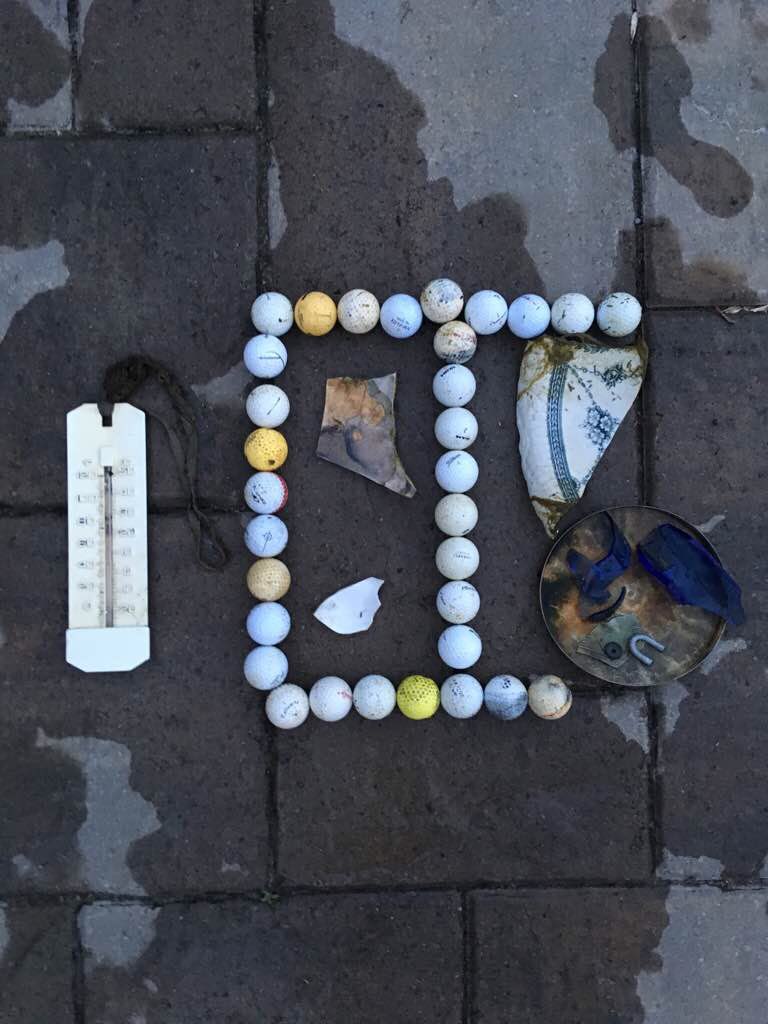
Thermometer
Sunny
1
0
0
0
0
0
0
0
0
0
0
0
0
0
0
0
0
0
0
Thermometer
Eli
0
0
0
0
0
0
0
0
0
0
0
0
0
0
0
0
0
0
0
2
0
0
0
0
0
0
0
0
0
0
35
0
0
0
10.00
90
16.40
6.56
0
estimated
0
0
64864.20
0
0
0
0
0
0
On
pounds
0
I have debris data to report
1
0
0
Calm (glassy to rippled) for waves 0 – 0.1 meter high
0
0
0
0
0
0
0
m2
0
0
feet
seagrass
0
0
0
0
0
0
0
0
0
0
0
0
0
0
0
0
0
2
0
0
0
1
0
0
0
0
0
0
Canada
State\Province
Quebec
City
Salaberry-de-Valleyfield
Map Help


Dive Location

If you know your survey site coordinates, enter them manually in decimal degrees using WGS84 Map Datum. Use the minus sign for latitudes south of the equator and longitudes west of the Prime Meridian to 180 degrees.

If you do not know your survey site coordinates, click the “Map Location” tab to use the map to zoom into your survey site and drop the pin on the map to fall within your survey dive site in the water (not on land or the beach). Ensure you zoom in as much as possible to ensure data accuracy.

Entangled Help


Use the vertical tabs below to record any entangled animals you found of each type.

Mourtias

0
0
0
0

39.210065, 23.33352

0
0
0
sand
0
8
0
3
0
We loaded the trash to the kayak.
Sunny
0
0
0
0
0
0
0
0
0
0
0
0
0
0
0
0
0
0
0
2
0
0
0
0
0
0
0
0
0
0
0
0
0
0
0
0
4.00
40
3.00
1.00
8
estimated
0
0
0
0
11614.50
0
0
0
0
0
0
On
kilograms
0
I have debris data to report
0
0
0
Smooth (wavelets) for waves 0.1 - 0.5 meter high
0
0
0
0
0
0
0
m2
0
0
meters
other
0
0
0
0
0
0
0
0
0
0
0
0
0
0
0
0
0
0
0
0
0
0
0
0
0
0
0
0
0
Greece
State\Province
Magnesia
City
Mourtias
Map Help


Dive Location

If you know your survey site coordinates, enter them manually in decimal degrees using WGS84 Map Datum. Use the minus sign for latitudes south of the equator and longitudes west of the Prime Meridian to 180 degrees.

If you do not know your survey site coordinates, click the “Map Location” tab to use the map to zoom into your survey site and drop the pin on the map to fall within your survey dive site in the water (not on land or the beach). Ensure you zoom in as much as possible to ensure data accuracy.

Entangled Help


Use the vertical tabs below to record any entangled animals you found of each type.

ADS92 - Grand Anse Beach

16
5

12.02443310548, -61.761974394321

sand
22
1

12.024126478452, -61.762154102325

general public use
toy truck fragment
Mild to No Surf, Partly Cloud with Scattered Showers
1
kite threading
Eco Dive
Christine Finney
1
6
1
20
16
2
6
23.00
70
6.00
1.00
measured
100.00
plastic fragments
fishing line
On
pounds
I have debris data to report
15
Smooth (wavelets) for waves 0.1 - 0.5 meter high
3
7
m2
1
meters
seagrass
6
2
Grenada
City
Saint George's
Map Help


Dive Location

If you know your survey site coordinates, enter them manually in decimal degrees using WGS84 Map Datum. Use the minus sign for latitudes south of the equator and longitudes west of the Prime Meridian to 180 degrees.

If you do not know your survey site coordinates, click the “Map Location” tab to use the map to zoom into your survey site and drop the pin on the map to fall within your survey dive site in the water (not on land or the beach). Ensure you zoom in as much as possible to ensure data accuracy.

Entangled Help


Use the vertical tabs below to record any entangled animals you found of each type.

ADS47 - West Hawk Lake Cats Ass

49.745667, -95.208556

silt

49.745266189094, -95.208348157181

Rain
Diver City SCUBA
Jacqui
16
0.00
25
60.00
10.00
measured
18000.00
On
pounds
Our Survey Site was free of debris
Smooth (wavelets) for waves 0.1 - 0.5 meter high m2
feet
other
Canada
State\Province
Manitoba
City
Winnipeg
Map Help


Dive Location

If you know your survey site coordinates, enter them manually in decimal degrees using WGS84 Map Datum. Use the minus sign for latitudes south of the equator and longitudes west of the Prime Meridian to 180 degrees.

If you do not know your survey site coordinates, click the “Map Location” tab to use the map to zoom into your survey site and drop the pin on the map to fall within your survey dive site in the water (not on land or the beach). Ensure you zoom in as much as possible to ensure data accuracy.

Entangled Help


Use the vertical tabs below to record any entangled animals you found of each type.

Ecosystem Other
Freshwater lake

ADS47 - West Hawk Lake Cats Ass

49.745667, -95.208556

silt
1
1

49.745369161664, -95.208447362395

Diver City SCUBA
Jacqui
3
1
4
1
1.00
50
80.00
35.00
estimated
1
1500.00
plastic beverage cups
On
pounds
I have debris data to report
Calm (glassy to rippled) for waves 0 – 0.1 meter high m2
feet
other
1
Canada
State\Province
Manitoba
City
Winnipeg
Map Help


Dive Location

If you know your survey site coordinates, enter them manually in decimal degrees using WGS84 Map Datum. Use the minus sign for latitudes south of the equator and longitudes west of the Prime Meridian to 180 degrees.

If you do not know your survey site coordinates, click the “Map Location” tab to use the map to zoom into your survey site and drop the pin on the map to fall within your survey dive site in the water (not on land or the beach). Ensure you zoom in as much as possible to ensure data accuracy.

Entangled Help


Use the vertical tabs below to record any entangled animals you found of each type.

Ecosystem Other
Freshwater lake
Subscribe to