Menu

Kangwon Do, Go Sung

1
rock
1

38.2963869, 128.5502482

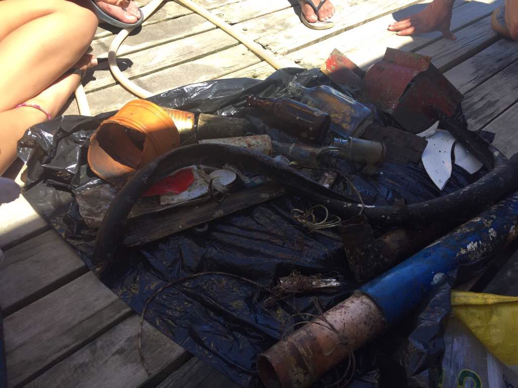
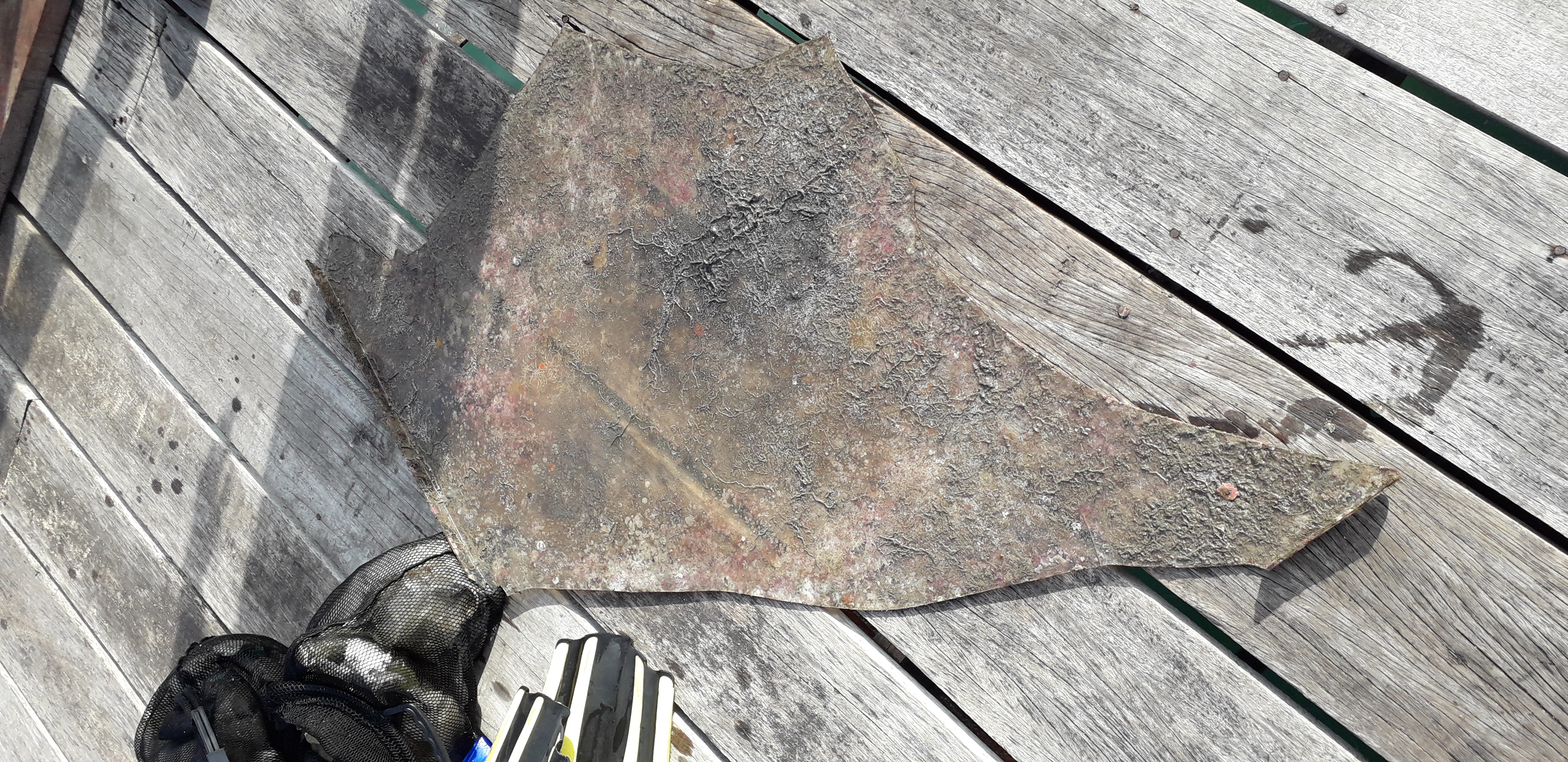
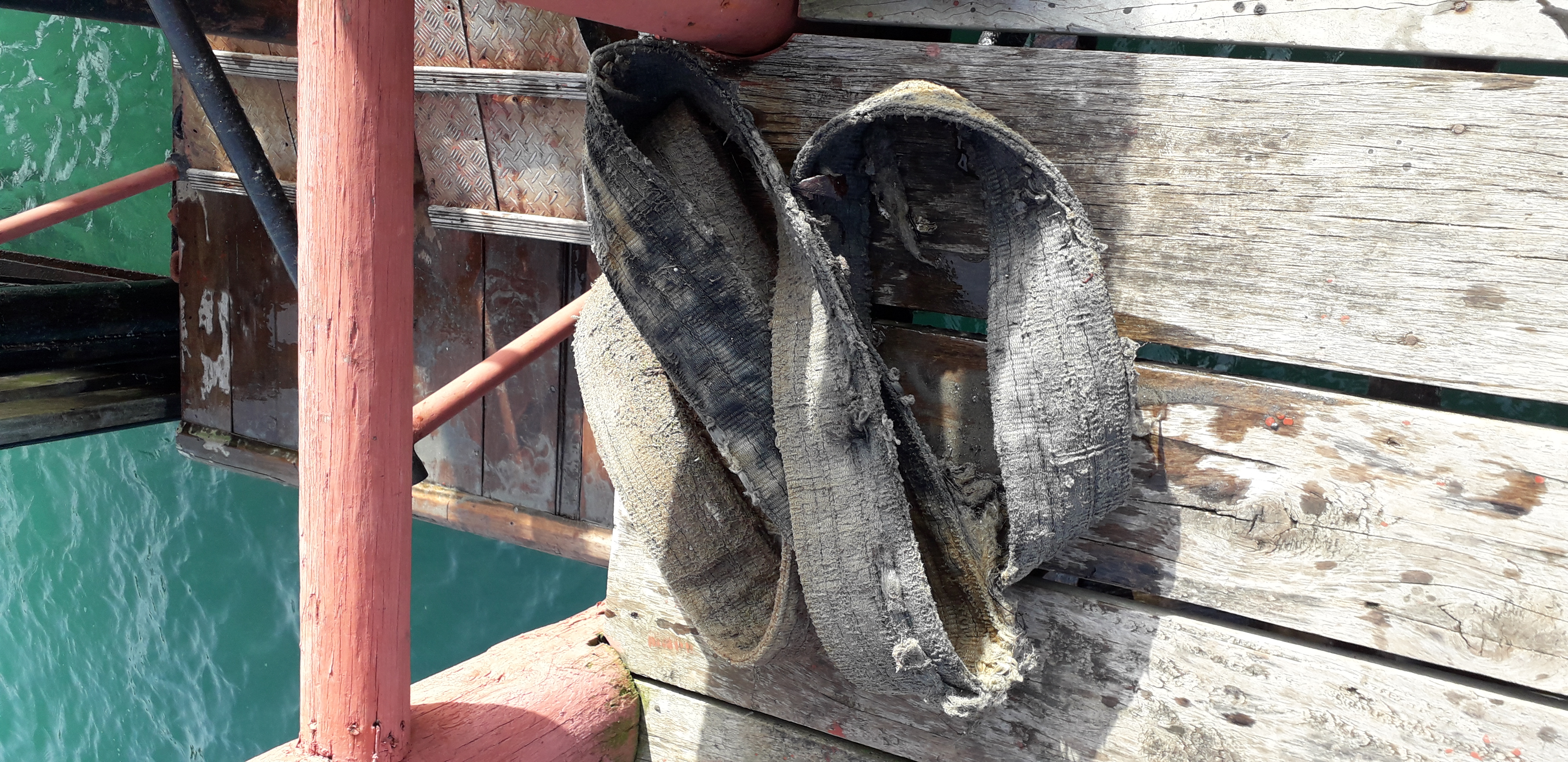
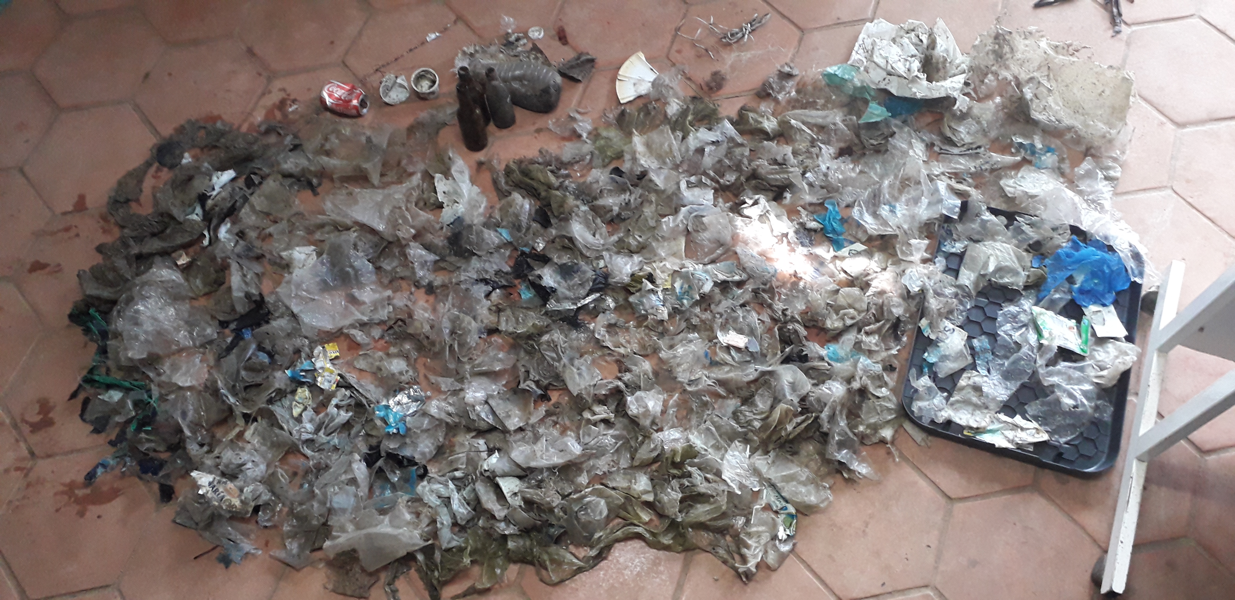
There was quite clean but some of diving point has many plastic debris which are plastic bags, gloves and some part of fishing materials.
That time was after education for PADI Openwater course. the divers was really happy with clean ocean.
Thank you for the Divers and clean ocean.
That was reallly good weather condition for collect derbis. no wind no wave and good divers
K-26
Jae Jung Park
1
7
5
1
4
10.00
60
6.00
1.00
3
estimated
1.00
shallow
between rocks
On
kilograms
Our Survey Site was free of debris
Calm (glassy to rippled) for waves 0 – 0.1 meter high m2
meters
rocky reef
South Korea
State\Province
Gapyeong-gun
City
Gyeonggi-do
Map Help


Dive Location

If you know your survey site coordinates, enter them manually in decimal degrees using WGS84 Map Datum. Use the minus sign for latitudes south of the equator and longitudes west of the Prime Meridian to 180 degrees.

If you do not know your survey site coordinates, click the “Map Location” tab to use the map to zoom into your survey site and drop the pin on the map to fall within your survey dive site in the water (not on land or the beach). Ensure you zoom in as much as possible to ensure data accuracy.

Entangled Help


Use the vertical tabs below to record any entangled animals you found of each type.

Cayo Largo, Cuba

0
20
0
0

21.597682, -81.528951

0
0
0
sand
0
6
0
1
0
No
Sunny
Jean Boisvert
0
0
0
12
0
0
0
0
0
0
11
0
0
0
0
0
0
35
0
1
0
0
0
0
0
0
15
0
0
4
1
0
0
1
0
0
10.00
20
0.00
0.00
2
estimated
0
0
0
0
12732.20
0
0
0
0
0
0
On
kilograms
0
I have debris data to report
0
0
0
Calm (glassy to rippled) for waves 0 – 0.1 meter high
6
0
6
0
2
0
0
m2
0
0
feet
other
0
0
0
0
0
0
0
0
0
0
0
0
0
0
0
0
0
0
0
0
0
0
0
0
0
0
0
0
0
Cuba
State\Province
Cuba
City
Cayo Largo
Map Help


Dive Location

If you know your survey site coordinates, enter them manually in decimal degrees using WGS84 Map Datum. Use the minus sign for latitudes south of the equator and longitudes west of the Prime Meridian to 180 degrees.

If you do not know your survey site coordinates, click the “Map Location” tab to use the map to zoom into your survey site and drop the pin on the map to fall within your survey dive site in the water (not on land or the beach). Ensure you zoom in as much as possible to ensure data accuracy.

Entangled Help


Use the vertical tabs below to record any entangled animals you found of each type.

ADS142 - Sabang Bay Puerto Galera

2
10
0

13.521685, 120.975398

0
0
0
sand
0
0
0
0
0
No
Metal rod 2m
Sunny
0
0
0
0
0
0
0
0
0
0
0
0
0
0
0
0
0
0
0
0
Asia Divers
Sabine Henkel
0
0
0
0
0
0
0
0
0
0
0
0
0
1
0
0
0
0
1
5
0
0
0
0
0
0
0
0
0
0
0
0
0
0
3.50
49
10.00
5.00
1
measured
0
0
300.00
0
0
1
6
0
Metal rod
Fishing lines
Rubber fragments
1
On
kilograms
0
I have debris data to report
1
0
0
Calm (glassy to rippled) for waves 0 – 0.1 meter high
0
0
0
0
0
0
0
m2
1
1
meters
coral reef
7
0
1
0
0
0
0
0
0
0
0
0
0
0
1
1
0
0
0
1
0
0
0
0
0
1
0
0
Philippines
State\Province
Mindoro
City
Puerto Galera
Map Help


Dive Location

If you know your survey site coordinates, enter them manually in decimal degrees using WGS84 Map Datum. Use the minus sign for latitudes south of the equator and longitudes west of the Prime Meridian to 180 degrees.

If you do not know your survey site coordinates, click the “Map Location” tab to use the map to zoom into your survey site and drop the pin on the map to fall within your survey dive site in the water (not on land or the beach). Ensure you zoom in as much as possible to ensure data accuracy.

Entangled Help


Use the vertical tabs below to record any entangled animals you found of each type.

ADS142 - Sabang Bay Puerto Galera

0
0
0

13.52512374397, 120.9704254882

0
0
0
sand
0
1
0
0
0
Human activities
Nill
Coral with net
Boat machinery
Fine
2
0
0
0
0
0
0
0
0
0
0
0
0
0
0
0
0
0
0
0
Boat machinery
Asia Divers
Matt
0
0
1
1
0
0
0
0
0
0
0
0
0
0
0
0
0
0
0
7
0
0
0
1
1
0
0
0
0
0
0
0
0
0
4.20
43
54.79
16.40
0
measured
0
0
5394.00
0
0
1
0
0
Glass bottles and cans
Tyre
Plastic
0
On
kilograms
0
I have debris data to report
4
1
0
Calm (glassy to rippled) for waves 0 – 0.1 meter high
0
0
0
Coral
Coral
Dead
1
0
0
0
0
ft2
0
0
feet
coral reef
0
0
0
0
0
2
0
0
0
0
0
0
0
0
0
0
0
0
0
0
0
6
0
0
6
0
0
0
Philippines
State\Province
Puerto Galera
City
Sabang
Map Help


Dive Location

If you know your survey site coordinates, enter them manually in decimal degrees using WGS84 Map Datum. Use the minus sign for latitudes south of the equator and longitudes west of the Prime Meridian to 180 degrees.

If you do not know your survey site coordinates, click the “Map Location” tab to use the map to zoom into your survey site and drop the pin on the map to fall within your survey dive site in the water (not on land or the beach). Ensure you zoom in as much as possible to ensure data accuracy.

Entangled Help


Use the vertical tabs below to record any entangled animals you found of each type.

ADS478 - Lagoon Beach

21
18
3
0

28.471703, 34.505836

0
0
0
seagrass
0
48
0
20
0
No
Still more to clean
Clased beer bottle
Calm
1
Sunglasses
Scuba Seekers Dive Club
Amr Zakaria Ali
0
2
0
43
23
0
0
0
2
2
2
0
8
5
1
0
0
4
0
2
3
0
0
0
2
2
74
0
0
0
0
0
0
0
0
0
41.50
38
15.00
5.00
6
measured
0
0
0
8
2000.00
0
1
1
0
0
Fishing line
Plastic bottles
Plastic cups
0
On
kilograms
0
I have debris data to report
26
0
0
Calm (glassy to rippled) for waves 0 – 0.1 meter high
0
0
3
0
0
0
1
m2
11
0
meters
seagrass
0
0
0
0
0
7
0
3
0
0
0
0
0
3
0
0
0
51
0
0
2
0
0
0
0
0
4
2
0
Egypt
State\Province
South Sinai
City
Dahab
Map Help


Dive Location

If you know your survey site coordinates, enter them manually in decimal degrees using WGS84 Map Datum. Use the minus sign for latitudes south of the equator and longitudes west of the Prime Meridian to 180 degrees.

If you do not know your survey site coordinates, click the “Map Location” tab to use the map to zoom into your survey site and drop the pin on the map to fall within your survey dive site in the water (not on land or the beach). Ensure you zoom in as much as possible to ensure data accuracy.

Entangled Help


Use the vertical tabs below to record any entangled animals you found of each type.

Cave 20

0
0
0
1

-6.151962, 39.529029

0
0
0
coral
0
0
0
0
0
Local Fishing
Released without any harm
Fishing Net removed
Net
Good
Rising Sun Dive Center
Tammy
0
0
0
0
0
0
0
0
0
0
0
0
0
0
0
0
0
0
0
3
0
0
0
0
0
0
0
0
0
0
0
0
0
0
0
0
5.00
60
23.00
12.00
0
estimated
0
0
0
0
3108.53
0
0
0
0
0
Fishing Net
Plastic bottles
Cement sand bags
0
On
kilograms
0
I have debris data to report
0
0
0
Slight for waves 0.5 -1.25 meter high
0
0
0
Fishing Net
Dead
Parrot Fish
Slipper Lobster
Released Unharmed
1
1
Fishing Net
Dead
Guitar Shark
1
0
0
0
0
m2
0
0
meters
coral reef
Fishing Net
0
0
0
0
0
0
0
0
0
0
0
0
0
0
0
0
0
0
0
0
0
0
0
0
0
0
0
0
0
Tanzania
City
Zanzibar
Map Help


Dive Location

If you know your survey site coordinates, enter them manually in decimal degrees using WGS84 Map Datum. Use the minus sign for latitudes south of the equator and longitudes west of the Prime Meridian to 180 degrees.

If you do not know your survey site coordinates, click the “Map Location” tab to use the map to zoom into your survey site and drop the pin on the map to fall within your survey dive site in the water (not on land or the beach). Ensure you zoom in as much as possible to ensure data accuracy.

Entangled Help


Use the vertical tabs below to record any entangled animals you found of each type.

Carlsbad pipeline

0
0
0

33.115230463308, -117.32661374322

0
0
0
sand
0
0
0
0
0
Rain
0
0
0
0
0
0
0
0
0
0
0
0
0
0
0
0
0
0
0
0
Jade Scuba Adventures
Ashley Arnold
0
0
0
0
0
0
0
0
0
0
0
0
0
0
0
0
0
0
0
4
0
0
0
0
0
0
0
0
0
0
0
0
0
0
0.00
53
24.00
8.00
0
measured
0
0
5853.59
0
0
0
0
0
0
On
kilograms
0
Our Survey Site was free of debris
0
0
0
Slight for waves 0.5 -1.25 meter high
0
0
0
0
0
0
0
ft2
0
0
feet
other
0
0
0
0
0
0
0
0
0
0
0
0
0
0
0
0
0
0
0
0
0
0
0
0
0
0
0
0
United States
State\Province
CA
City
Carlsbad
Map Help


Dive Location

If you know your survey site coordinates, enter them manually in decimal degrees using WGS84 Map Datum. Use the minus sign for latitudes south of the equator and longitudes west of the Prime Meridian to 180 degrees.

If you do not know your survey site coordinates, click the “Map Location” tab to use the map to zoom into your survey site and drop the pin on the map to fall within your survey dive site in the water (not on land or the beach). Ensure you zoom in as much as possible to ensure data accuracy.

Entangled Help


Use the vertical tabs below to record any entangled animals you found of each type.

ADS512 - La Lobera

0
0
0
0

26.124895, -111.260616

2
0
0
sand
0
3
0
0
0
20390
Rafael Murillo
0
0
0
1
0
0
0
0
1
0
0
0
0
0
0
0
0
0
0
5
0
0
0
0
1
0
4
0
1
2
0
0
0
0
0
0
3.00
40
17.00
3.00
0
estimated
1
0
0
0
170.66
1
0
0
0
0
2
On
kilograms
0
I have debris data to report
0
0
0
Smooth (wavelets) for waves 0.1 - 0.5 meter high
0
0
0
0
0
0
0
m2
0
0
meters
rocky reef
0
0
0
0
0
0
0
0
0
0
0
0
0
0
0
0
0
0
0
0
0
0
0
0
0
0
0
0
0
Mexico
State\Province
bcs
City
loreto
Map Help


Dive Location

If you know your survey site coordinates, enter them manually in decimal degrees using WGS84 Map Datum. Use the minus sign for latitudes south of the equator and longitudes west of the Prime Meridian to 180 degrees.

If you do not know your survey site coordinates, click the “Map Location” tab to use the map to zoom into your survey site and drop the pin on the map to fall within your survey dive site in the water (not on land or the beach). Ensure you zoom in as much as possible to ensure data accuracy.

Entangled Help


Use the vertical tabs below to record any entangled animals you found of each type.

Sheridan

27.8763, -83.185833

sand
3
5
King of the beach St. Petersburg
Dominic Black Foundation
Dominic Black
3
15
2
60.00
45
80.00
65.00
estimated
25000.00
Bottles
Cans
On
pounds
I have debris data to report
3
Moderate to rough for waves greater than 1.25 meters ft2
feet
other
5
10
3
United States
State\Province
Florida
City
Seminole
Map Help


Dive Location

If you know your survey site coordinates, enter them manually in decimal degrees using WGS84 Map Datum. Use the minus sign for latitudes south of the equator and longitudes west of the Prime Meridian to 180 degrees.

If you do not know your survey site coordinates, click the “Map Location” tab to use the map to zoom into your survey site and drop the pin on the map to fall within your survey dive site in the water (not on land or the beach). Ensure you zoom in as much as possible to ensure data accuracy.

Entangled Help


Use the vertical tabs below to record any entangled animals you found of each type.

Ecosystem Other
Wreck

Ilheu Bom Bom

300
1
1
1
sand
548
2

1.6954262281584, 7.4024438531752

No
ghost fishing
fishing net
ghost fishing
Stormy and windy
Bom Bom Dive Center
Flávio Quina
3
3
2
2
140
60
2
0
10.00
18
5.00
3.00
1
estimated
30.00
plastic bags
fishing net
On
kilograms
I have debris data to report
3
Calm (glassy to rippled) for waves 0 – 0.1 meter high
Dead
Red Snapper
1
fishing net
m2
meters
other
1
1
3
1
fishing net
Released Unharmed
Olive ridley
Sao Tome and Principe
State\Province
Principe
City
Santo Antonio
Map Help


Dive Location

If you know your survey site coordinates, enter them manually in decimal degrees using WGS84 Map Datum. Use the minus sign for latitudes south of the equator and longitudes west of the Prime Meridian to 180 degrees.

If you do not know your survey site coordinates, click the “Map Location” tab to use the map to zoom into your survey site and drop the pin on the map to fall within your survey dive site in the water (not on land or the beach). Ensure you zoom in as much as possible to ensure data accuracy.

Entangled Help


Use the vertical tabs below to record any entangled animals you found of each type.

Ecosystem Other
Sandy
Subscribe to