Calm (glassy to rippled) for waves 0 – 0.1 meter high
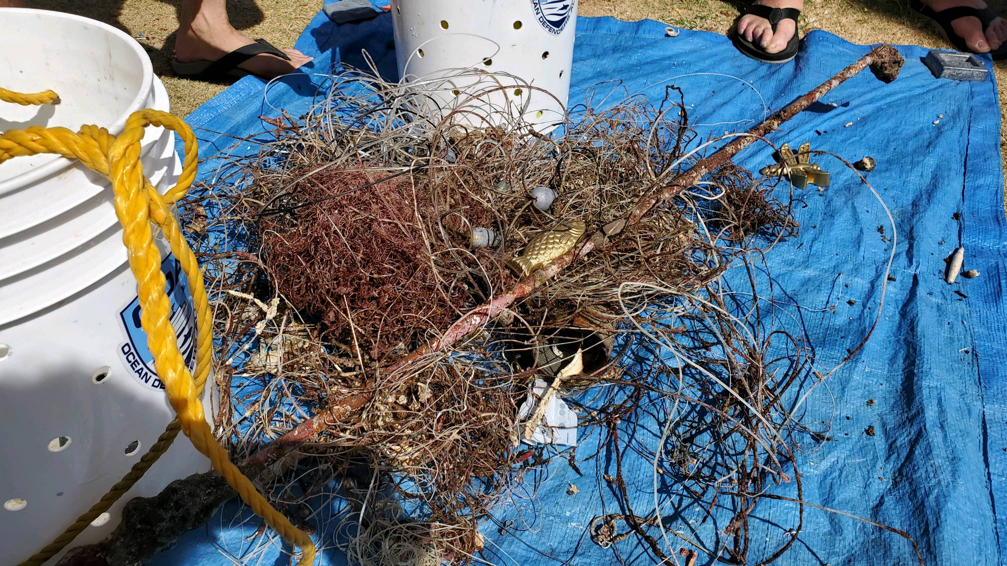
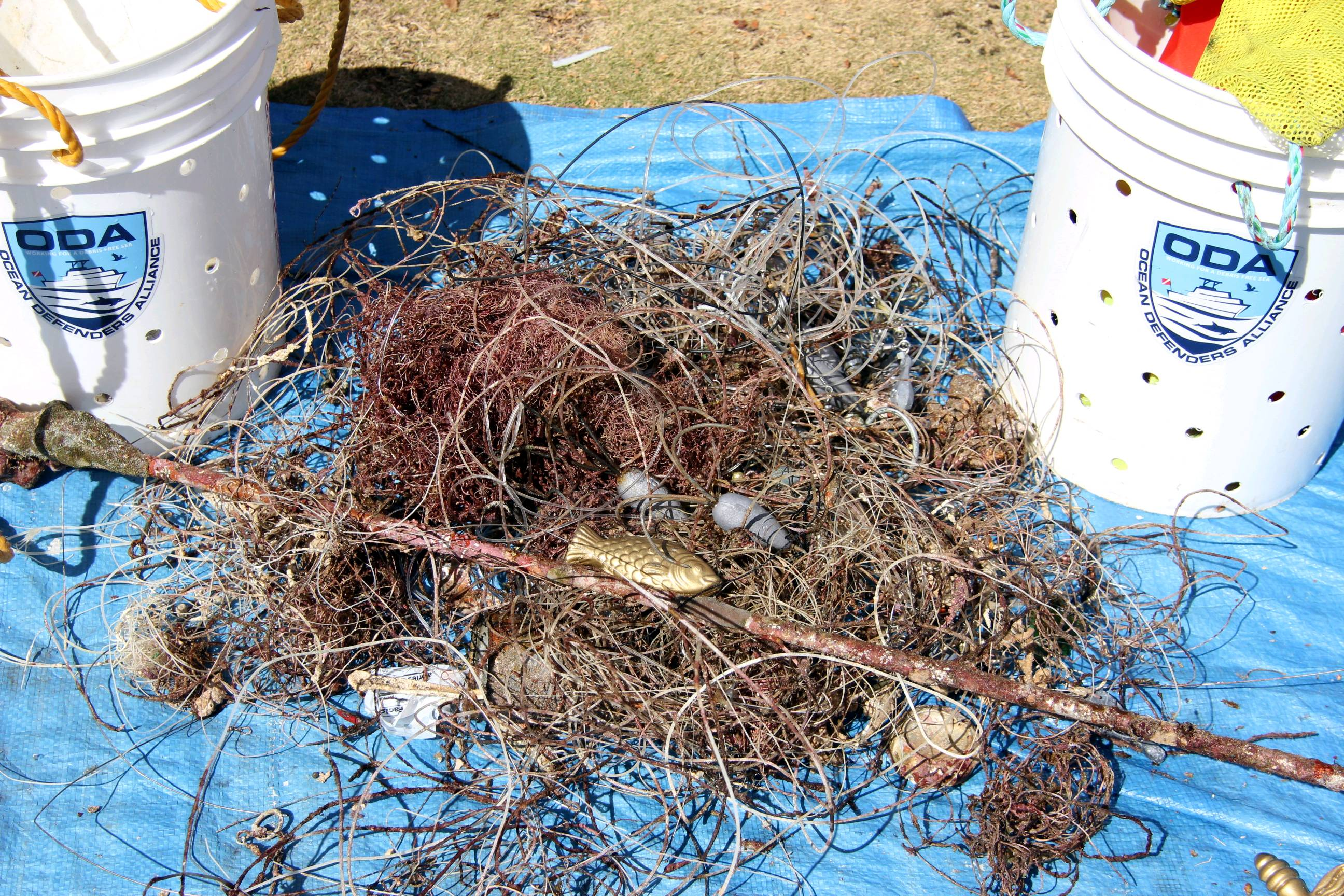
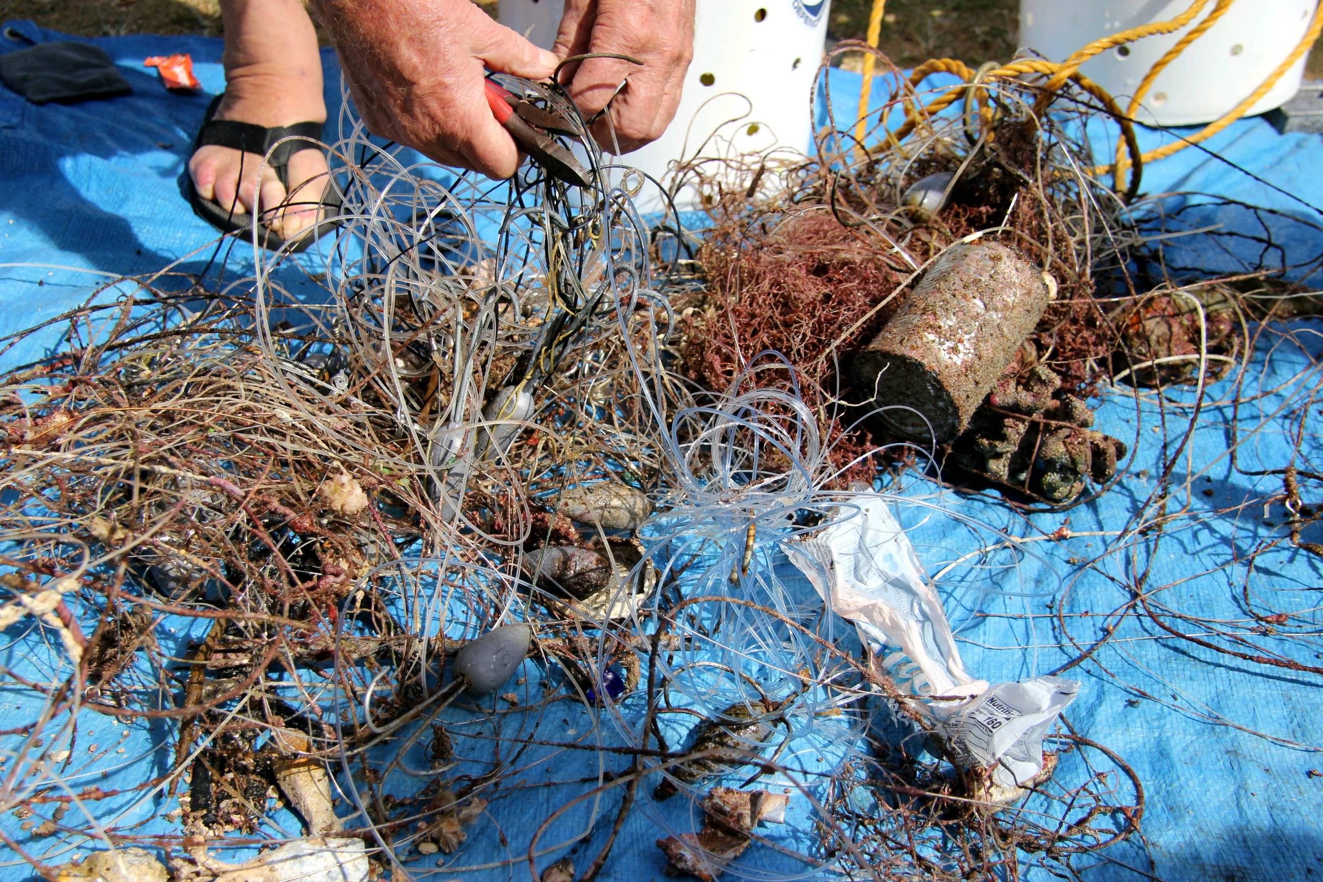
cans , plastic bottles
Injured
various small fish
Crabs + crayfish
Released Unharmed
20
10
cans and bottles
1
m2
meters
seagrass
2
1
2
61
Greece
State\Province
Corinthia
City
Loutraki
Map Help
Dive Location
If you know your survey site coordinates, enter them manually in decimal degrees using WGS84 Map Datum. Use the minus sign for latitudes south of the equator and longitudes west of the Prime Meridian to 180 degrees.
If you do not know your survey site coordinates, click the “Map Location” tab to use the map to zoom into your survey site and drop the pin on the map to fall within your survey dive site in the water (not on land or the beach). Ensure you zoom in as much as possible to ensure data accuracy.
Entangled Help
Use the vertical tabs below to record any entangled animals you found of each type.
This artifical reef is a large tetrahedron-shaped metal structure that reaches from the bottom to 9m depth. It has only been placed there in Februrary this year, thus it's relatively new. We assume that a lot of fishermen do not know about the reef, which is probably why a lot of fishing nets get stuck there.
Large metal gas cylinder (11kg).
Temple Adventures
Donarun Das
9
18.30
30
17.00
9.00
2
measured
20
25.00
Fishing nets
On
kilograms
I have debris data to report
Calm (glassy to rippled) for waves 0 – 0.1 meter high
fishing net
Released Unharmed
Whitecheek Monocle Bream
Crab
Dead
1
1
fishing net
m2
meters
other
1
Language
English
India
State\Province
Puducherry
City
Puducherry
Map Help
Dive Location
If you know your survey site coordinates, enter them manually in decimal degrees using WGS84 Map Datum. Use the minus sign for latitudes south of the equator and longitudes west of the Prime Meridian to 180 degrees.
If you do not know your survey site coordinates, click the “Map Location” tab to use the map to zoom into your survey site and drop the pin on the map to fall within your survey dive site in the water (not on land or the beach). Ensure you zoom in as much as possible to ensure data accuracy.
Entangled Help
Use the vertical tabs below to record any entangled animals you found of each type.
Smooth (wavelets) for waves 0.1 - 0.5 meter high
m2
meters
coral reef
4
Language
English
Indonesia
State\Province
Suluwesi
City
Manado
Map Help
Dive Location
If you know your survey site coordinates, enter them manually in decimal degrees using WGS84 Map Datum. Use the minus sign for latitudes south of the equator and longitudes west of the Prime Meridian to 180 degrees.
If you do not know your survey site coordinates, click the “Map Location” tab to use the map to zoom into your survey site and drop the pin on the map to fall within your survey dive site in the water (not on land or the beach). Ensure you zoom in as much as possible to ensure data accuracy.
Entangled Help
Use the vertical tabs below to record any entangled animals you found of each type.
Need link for DETAILS on recording fishing line. I am counting 10 yards as 1 unit. 100 = 1000 yards.
Popular fishing area for ulua (giant trevaly), big jacks, ahi
Mainly fishing line today, usually more lead weights. Also I entered 7500 sq ft but it's showing as 80,000.
Fishing pole or tent pole
Need pliers, wire cutters to flatten barbs for removal
2 to 4 ft east swell wrapping around to south
Ocean Defenders Alliance w Island Divers Hawaii
Andrew Monnig, OWSI 398573
0
0
0
0
0
0
0
0
0
0
0
0
0
0
0
0
0
0
0
16
0
0
0
0
0
0
2
0
0
0
0
0
0
0
0
0
80.00
40
74.00
46.00
0
estimated
0
0
0
50
7500.00
0
0
0
0
0
Heavy fishing line, massive hooks which kill fish and turtles
0
On
pounds
0
I have debris data to report
0
0
0
Moderate to rough for waves greater than 1.25 meters
0
0
0
Injured
Giant Porcupine Fish
1
Giant hook through his eye, lots of tackle trailing, could not remove hook
0
0
0
0
ft2
0
0
feet
coral reef
0
0
0
0
0
0
0
0
0
0
0
0
0
0
0
0
3
6
0
0
0
0
0
0
0
0
0
0
0
Language
English
United States
State\Province
HI
City
Hawaii Kai
Map Help
Dive Location
If you know your survey site coordinates, enter them manually in decimal degrees using WGS84 Map Datum. Use the minus sign for latitudes south of the equator and longitudes west of the Prime Meridian to 180 degrees.
If you do not know your survey site coordinates, click the “Map Location” tab to use the map to zoom into your survey site and drop the pin on the map to fall within your survey dive site in the water (not on land or the beach). Ensure you zoom in as much as possible to ensure data accuracy.
Entangled Help
Use the vertical tabs below to record any entangled animals you found of each type.
Calm (glassy to rippled) for waves 0 – 0.1 meter high
0
0
0
Dead
Burritas
4
Fish Net
0
0
0
0
m2
0
0
meters
other
0
0
0
0
0
0
0
0
0
0
0
0
0
0
0
0
0
0
0
0
0
0
0
0
0
0
0
0
0
Language
English
El Salvador
State\Province
San Salvador
City
Ilopango
Map Help
Dive Location
If you know your survey site coordinates, enter them manually in decimal degrees using WGS84 Map Datum. Use the minus sign for latitudes south of the equator and longitudes west of the Prime Meridian to 180 degrees.
If you do not know your survey site coordinates, click the “Map Location” tab to use the map to zoom into your survey site and drop the pin on the map to fall within your survey dive site in the water (not on land or the beach). Ensure you zoom in as much as possible to ensure data accuracy.
Entangled Help
Use the vertical tabs below to record any entangled animals you found of each type.
sweeping the water for Port of Antwerp triatlon and safety divers during the event
sunny and warm
1
3
1
4
6
1
Wooden boat 6 m
Bicycle
Step
Traffic Sign
Metal Fence
Engine
buddiesnbubbles
Werner Van Loon
1
4
2
1
5
5
600.00
52
6.00
1.00
12
estimated
200.00
On
kilograms
I have debris data to report
Calm (glassy to rippled) for waves 0 – 0.1 meter high
m2
meters
other
Language
English
Belgium
State\Province
antwerpen
City
antwerpen
Map Help
Dive Location
If you know your survey site coordinates, enter them manually in decimal degrees using WGS84 Map Datum. Use the minus sign for latitudes south of the equator and longitudes west of the Prime Meridian to 180 degrees.
If you do not know your survey site coordinates, click the “Map Location” tab to use the map to zoom into your survey site and drop the pin on the map to fall within your survey dive site in the water (not on land or the beach). Ensure you zoom in as much as possible to ensure data accuracy.
Entangled Help
Use the vertical tabs below to record any entangled animals you found of each type.
Calm (glassy to rippled) for waves 0 – 0.1 meter high
m2
9
meters
coral reef
3
10
1
1
12
1
26
11
14
3
2
Language
English
Netherlands Antilles
City
Willemstad
Map Help
Dive Location
If you know your survey site coordinates, enter them manually in decimal degrees using WGS84 Map Datum. Use the minus sign for latitudes south of the equator and longitudes west of the Prime Meridian to 180 degrees.
If you do not know your survey site coordinates, click the “Map Location” tab to use the map to zoom into your survey site and drop the pin on the map to fall within your survey dive site in the water (not on land or the beach). Ensure you zoom in as much as possible to ensure data accuracy.
Entangled Help
Use the vertical tabs below to record any entangled animals you found of each type.
Calm (glassy to rippled) for waves 0 – 0.1 meter high
0
0
0
0
0
0
0
m2
0
0
meters
coral reef
0
0
0
0
0
0
0
0
0
0
0
0
0
0
0
0
0
0
0
0
0
0
0
0
0
0
0
0
0
Language
English
Indonesia
State\Province
Lombok NTB
City
Gili Trawangan
Map Help
Dive Location
If you know your survey site coordinates, enter them manually in decimal degrees using WGS84 Map Datum. Use the minus sign for latitudes south of the equator and longitudes west of the Prime Meridian to 180 degrees.
If you do not know your survey site coordinates, click the “Map Location” tab to use the map to zoom into your survey site and drop the pin on the map to fall within your survey dive site in the water (not on land or the beach). Ensure you zoom in as much as possible to ensure data accuracy.
Entangled Help
Use the vertical tabs below to record any entangled animals you found of each type.