Menu

Seahorse Bay

9
15
2
coral
3
5

12.172031720999, 109.30420455479

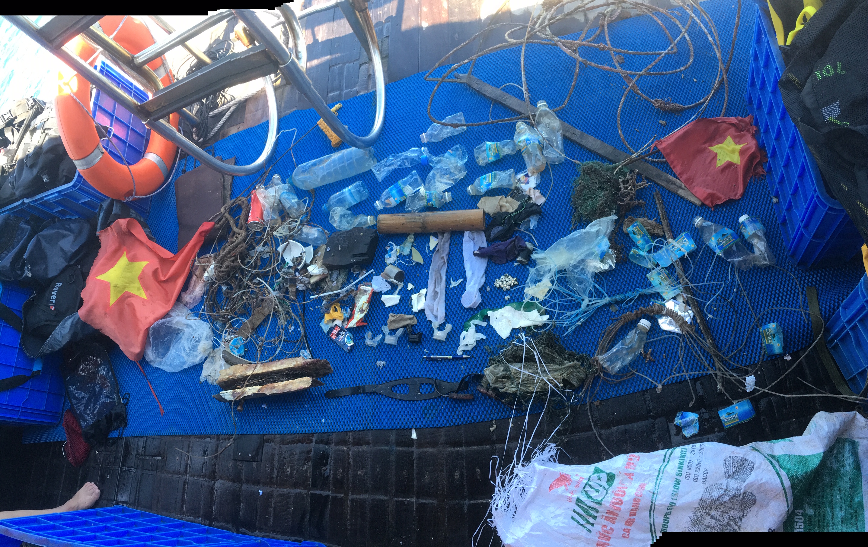
Litter thrown over the sides of tourist boats, fishing activities
Vietnamese flags
Mostly calm, some strong winds
2
1
Vietnamese flag
Hairclip
Rainbow Divers
Maisie MacGregor
5
5
1
1
12
1
19
1
6.00
40
16.00
5.00
1
estimated
3000.00
Huge amount of plastic water bottles
Plastic fishing line tangled on coral
200
On
kilograms
I have debris data to report
Smooth (wavelets) for waves 0.1 - 0.5 meter high
5
8
m2
meters
coral reef
1
2
1
1
Vietnam
City
Nha Trang
Map Help


Dive Location

If you know your survey site coordinates, enter them manually in decimal degrees using WGS84 Map Datum. Use the minus sign for latitudes south of the equator and longitudes west of the Prime Meridian to 180 degrees.

If you do not know your survey site coordinates, click the “Map Location” tab to use the map to zoom into your survey site and drop the pin on the map to fall within your survey dive site in the water (not on land or the beach). Ensure you zoom in as much as possible to ensure data accuracy.

Entangled Help


Use the vertical tabs below to record any entangled animals you found of each type.

ADS126 - Chilpo Beach Northern Rocky outcrop

11
1

36.136072, 129.398292

sand
1
We went in 3 people for a PADI DMT mapping project, and to familiarize the two others with the area for a larger cleanup event coming soon. The water was just nasty and vis was barely 1 meter. We didnt intend to remove debris but as they say never let a dive go to waste..even when diving in low vis water. The anchor was a tough one to remove alone, but it made a great centerpiece for our evening camping
I am not sure why, but the form autofill is no longer working for me when I fill out surveys.
Anchor. I have never seen it here before and cant imagine how it suddenly appeared in this area.
Fish was dead with hooks in mouth on broken leader line and fishing line
Calm.
1
metal anchor
Dive Against Debris Korea (Daegu)
William Henderson
3
14.00
20
4.00
1.00
4
estimated
5
20.00
plastic
cloth gloves
On
kilograms
I have debris data to report
Smooth (wavelets) for waves 0.1 - 0.5 meter high
1
Dead
Fish
1
Hooks and broken fishing line
2
m2
meters
rocky reef
3
South Korea
State\Province
Gyeongsangbukdo
City
Pohang
Map Help


Dive Location

If you know your survey site coordinates, enter them manually in decimal degrees using WGS84 Map Datum. Use the minus sign for latitudes south of the equator and longitudes west of the Prime Meridian to 180 degrees.

If you do not know your survey site coordinates, click the “Map Location” tab to use the map to zoom into your survey site and drop the pin on the map to fall within your survey dive site in the water (not on land or the beach). Ensure you zoom in as much as possible to ensure data accuracy.

Entangled Help


Use the vertical tabs below to record any entangled animals you found of each type.

Newport Beach Duffy Service Docks

0
0
0
0

33.619161, -117.923777

0
0
0
sand
0
1
0
0
1
Docks next to GuacAmigos
No
VCR
Unknown? Cloudy for today
Beach Cities Scuba
Sheen
0
1
0
1
1
0
0
0
1
0
0
0
0
0
0
0
0
0
0
10
0
0
0
0
0
0
0
0
0
0
1
0
0
0
0
0
60.00
60
18.00
5.00
1
estimated
0
0
0
0
905.30
0
0
0
0
0
Dock bumpers
0
On
pounds
0
I have debris data to report
2
0
0
Smooth (wavelets) for waves 0.1 - 0.5 meter high
0
0
0
0
0
0
0
ft2
1
0
feet
seagrass
0
0
0
0
0
0
0
0
0
0
0
0
0
0
0
0
0
2
0
0
0
0
0
0
0
2
0
0
0
United States
State\Province
CA
City
Newport Beach
Map Help


Dive Location

If you know your survey site coordinates, enter them manually in decimal degrees using WGS84 Map Datum. Use the minus sign for latitudes south of the equator and longitudes west of the Prime Meridian to 180 degrees.

If you do not know your survey site coordinates, click the “Map Location” tab to use the map to zoom into your survey site and drop the pin on the map to fall within your survey dive site in the water (not on land or the beach). Ensure you zoom in as much as possible to ensure data accuracy.

Entangled Help


Use the vertical tabs below to record any entangled animals you found of each type.

Dock 6 Balboa

0
0
0
0

33.615352, -117.915376

0
0
0
silt
0
0
0
0
0
Balboa harbour clean up
Overcast
Balboa Harbour Clean Up
Suzy Degazon
0
2
1
0
0
1
0
0
0
0
0
0
0
0
0
0
0
0
0
3
0
0
0
0
0
0
0
0
0
0
1
0
0
0
0
0
15.00
60
10.00
8.00
1
estimated
0
0
0
0
6808.72
0
0
0
0
0
0
On
pounds
0
I have debris data to report
0
0
0
Calm (glassy to rippled) for waves 0 – 0.1 meter high
0
0
0
0
0
0
0
ft2
0
0
feet
other
0
0
0
0
0
0
0
0
0
0
0
0
0
0
0
0
0
0
0
0
0
0
0
0
0
0
0
0
0
United States
State\Province
CA
City
Newport
Map Help


Dive Location

If you know your survey site coordinates, enter them manually in decimal degrees using WGS84 Map Datum. Use the minus sign for latitudes south of the equator and longitudes west of the Prime Meridian to 180 degrees.

If you do not know your survey site coordinates, click the “Map Location” tab to use the map to zoom into your survey site and drop the pin on the map to fall within your survey dive site in the water (not on land or the beach). Ensure you zoom in as much as possible to ensure data accuracy.

Entangled Help


Use the vertical tabs below to record any entangled animals you found of each type.

ADS446 - Cala Reona

4
20
5
rock

37.617562835381, -0.71482220024507

Windy
Scuba Murcia
Joanna Golder
10
4
4
4
1
1.60
45
6.00
1.50
estimated
80.00
On
pounds
I have debris data to report
Smooth (wavelets) for waves 0.1 - 0.5 meter high m2
meters
rocky reef
Spain
State\Province
Murcia
City
La Manga
Map Help


Dive Location

If you know your survey site coordinates, enter them manually in decimal degrees using WGS84 Map Datum. Use the minus sign for latitudes south of the equator and longitudes west of the Prime Meridian to 180 degrees.

If you do not know your survey site coordinates, click the “Map Location” tab to use the map to zoom into your survey site and drop the pin on the map to fall within your survey dive site in the water (not on land or the beach). Ensure you zoom in as much as possible to ensure data accuracy.

Entangled Help


Use the vertical tabs below to record any entangled animals you found of each type.

ADS553 - Mary's Place

3
5
7
0

16.338723, -86.471106

0
0
0
seagrass
1
8
0
0
0
Following this Dive Against Debris submission, we will be proceeding to adopt Mary's Place per thr Adopt A Site program
After the rain, the outwash from the neighboring communities around the site.
Cell phone
Clear and calm
Barefoot Divers
Ronal Reyes
3
3
0
5
0
0
0
0
0
1
0
0
0
0
2
2
0
5
0
1
0
0
0
0
12
0
12
2
0
7
1
1
0
2
0
0
25.00
45
15.00
15.00
1
estimated
0
0
0
0
473.43
0
0
0
0
0
Plastic
Styrofoam
Glass
0
On
pounds
0
I have debris data to report
3
0
0
Calm (glassy to rippled) for waves 0 – 0.1 meter high
0
0
1
0
0
0
0
m2
0
0
feet
coral reef
0
0
0
0
2
2
0
0
0
0
0
0
0
0
0
0
5
17
0
0
1
0
2
0
1
0
3
4
0
Honduras
State\Province
Roatan
City
Brick Bay
Map Help


Dive Location

If you know your survey site coordinates, enter them manually in decimal degrees using WGS84 Map Datum. Use the minus sign for latitudes south of the equator and longitudes west of the Prime Meridian to 180 degrees.

If you do not know your survey site coordinates, click the “Map Location” tab to use the map to zoom into your survey site and drop the pin on the map to fall within your survey dive site in the water (not on land or the beach). Ensure you zoom in as much as possible to ensure data accuracy.

Entangled Help


Use the vertical tabs below to record any entangled animals you found of each type.

ADS565 - БДЖ (Poseidon Beach)

40.020423, 23.834258

sand
Sunny, water temperature +19, visibility 15 meters
Nemo Scuba Diving Resort
Ilya Dobrodeev
4
1.00
120
40.00
4.00
estimated
300.00
On
kilograms
I have debris data to report
Calm (glassy to rippled) for waves 0 – 0.1 meter high m2
meters
rocky reef
5
Greece
State\Province
Halkidiki
City
Metamorfosi
Map Help


Dive Location

If you know your survey site coordinates, enter them manually in decimal degrees using WGS84 Map Datum. Use the minus sign for latitudes south of the equator and longitudes west of the Prime Meridian to 180 degrees.

If you do not know your survey site coordinates, click the “Map Location” tab to use the map to zoom into your survey site and drop the pin on the map to fall within your survey dive site in the water (not on land or the beach). Ensure you zoom in as much as possible to ensure data accuracy.

Entangled Help


Use the vertical tabs below to record any entangled animals you found of each type.

ADS551 - St Leonards Pier

-38.170506361724, 144.71944724921

9
sand
4

-38.1705513, 144.7188627

Popular local fishing pier, fishing waste is common at this site.
Rain
Australian Diving Instruction
Ting Ting Lee
5
0.50
72
4.00
2.50
estimated
800.00
Fishing line
Fishing lure
On
kilograms
I have debris data to report
Calm (glassy to rippled) for waves 0 – 0.1 meter high m2
meters
rocky reef
Australia
State\Province
Victoria
City
Geelong
Map Help


Dive Location

If you know your survey site coordinates, enter them manually in decimal degrees using WGS84 Map Datum. Use the minus sign for latitudes south of the equator and longitudes west of the Prime Meridian to 180 degrees.

If you do not know your survey site coordinates, click the “Map Location” tab to use the map to zoom into your survey site and drop the pin on the map to fall within your survey dive site in the water (not on land or the beach). Ensure you zoom in as much as possible to ensure data accuracy.

Entangled Help


Use the vertical tabs below to record any entangled animals you found of each type.

Haagseveer

0
137
0
0

51.923516, 4.481355

0
2
0
silt
0
234
23
0
0
Plastic bags
Good sunny
2
Bike
Maidiving
Vincent Maissan
0
0
3
11
0
0
0
0
0
0
0
0
0
0
0
0
0
0
0
12
0
0
0
0
31
0
29
0
0
9
3
0
0
0
0
0
400.00
90
3.00
1.00
0
estimated
0
0
0
0
1757.51
0
1
0
0
0
Bags
Beer botles
0
On
kilograms
0
I have debris data to report
14
2
0
Calm (glassy to rippled) for waves 0 – 0.1 meter high
0
0
0
0
0
0
0
m2
0
0
meters
other
0
1
3
2
0
0
0
0
0
0
1
0
0
0
0
0
0
0
0
0
0
0
6
0
0
0
0
0
0
Netherlands
State\Province
Zuid Holland
City
Rotterdam
Map Help


Dive Location

If you know your survey site coordinates, enter them manually in decimal degrees using WGS84 Map Datum. Use the minus sign for latitudes south of the equator and longitudes west of the Prime Meridian to 180 degrees.

If you do not know your survey site coordinates, click the “Map Location” tab to use the map to zoom into your survey site and drop the pin on the map to fall within your survey dive site in the water (not on land or the beach). Ensure you zoom in as much as possible to ensure data accuracy.

Entangled Help


Use the vertical tabs below to record any entangled animals you found of each type.

ADS455 - House Reef Toberua

0
2
0
0

-17.975254, 178.703459

1
0
0
sand
0
0
0
5
0
Local fishermen
Coffee mug
Toberua Divers
Everette Ingram
0
0
0
0
0
0
0
0
0
0
0
0
0
0
0
0
0
0
0
5
0
0
0
0
0
0
0
0
0
1
0
0
0
0
0
0
17.80
39
14.00
3.00
0
measured
0
0
0
0
533.00
0
0
0
0
0
Glass bottles
Fishing line
Fishing pole
0
On
kilograms
0
I have debris data to report
20
0
0
Calm (glassy to rippled) for waves 0 – 0.1 meter high
0
0
0
0
0
0
0
m2
0
0
meters
coral reef
0
0
0
0
0
0
0
0
0
0
0
0
0
0
0
0
0
0
0
0
1
0
0
0
0
0
0
0
0
Fiji
City
Toberua Island
Map Help


Dive Location

If you know your survey site coordinates, enter them manually in decimal degrees using WGS84 Map Datum. Use the minus sign for latitudes south of the equator and longitudes west of the Prime Meridian to 180 degrees.

If you do not know your survey site coordinates, click the “Map Location” tab to use the map to zoom into your survey site and drop the pin on the map to fall within your survey dive site in the water (not on land or the beach). Ensure you zoom in as much as possible to ensure data accuracy.

Entangled Help


Use the vertical tabs below to record any entangled animals you found of each type.

Subscribe to