Menu

ADS02 - Montaña Amarilla

rock

28.009260260485, -16.638209509283

One Two Dive (12dive)
Matt Day
3
0.00
53
22.00
3.00
measured
200.00
On
kilograms
Our Survey Site was free of debris
Smooth (wavelets) for waves 0.1 - 0.5 meter high m2
meters
rocky reef
Spain
Map Help


Dive Location

If you know your survey site coordinates, enter them manually in decimal degrees using WGS84 Map Datum. Use the minus sign for latitudes south of the equator and longitudes west of the Prime Meridian to 180 degrees.

If you do not know your survey site coordinates, click the “Map Location” tab to use the map to zoom into your survey site and drop the pin on the map to fall within your survey dive site in the water (not on land or the beach). Ensure you zoom in as much as possible to ensure data accuracy.

Entangled Help


Use the vertical tabs below to record any entangled animals you found of each type.

Octopus Rock

5

12.171103439769, 109.31296048494

coral
2
Very hot and sunny, cloudy in afternoon, some rain in evening
Sailing Club Divers
Vu Lam
2
1
4.00
25
12.00
7.00
4
estimated
300.00
On
kilograms
I have debris data to report
Calm (glassy to rippled) for waves 0 – 0.1 meter high
1
m2
meters
coral reef
Vietnam
State\Province
Khanh Hoa
City
Nha Trang
Map Help


Dive Location

If you know your survey site coordinates, enter them manually in decimal degrees using WGS84 Map Datum. Use the minus sign for latitudes south of the equator and longitudes west of the Prime Meridian to 180 degrees.

If you do not know your survey site coordinates, click the “Map Location” tab to use the map to zoom into your survey site and drop the pin on the map to fall within your survey dive site in the water (not on land or the beach). Ensure you zoom in as much as possible to ensure data accuracy.

Entangled Help


Use the vertical tabs below to record any entangled animals you found of each type.

Clifton Gardens

1
sand

-33.839260866967, 151.25391686902

Calm, warm
Atlassian
Eve Claydon
1
9
10
1
17.00
50
10.00
1.00
measured
15386.20
battery
On
kilograms
I have debris data to report
14
Slight for waves 0.5 -1.25 meter high
4
m2
meters
other
13
2
Australia
State\Province
NSW
City
Sydney
Map Help


Dive Location

If you know your survey site coordinates, enter them manually in decimal degrees using WGS84 Map Datum. Use the minus sign for latitudes south of the equator and longitudes west of the Prime Meridian to 180 degrees.

If you do not know your survey site coordinates, click the “Map Location” tab to use the map to zoom into your survey site and drop the pin on the map to fall within your survey dive site in the water (not on land or the beach). Ensure you zoom in as much as possible to ensure data accuracy.

Entangled Help


Use the vertical tabs below to record any entangled animals you found of each type.

Ecosystem Other
Beach

Clifton Gardens, Mosman, Sydney

7
sand
11

-33.839595787667, 151.2528627492

Remnants of a children's birthday party (balloons, etc), were on a nearby picnic table.
Latest model iphone
Calm, warm.
Atlassian
Eve Claydon
1
11
1
9
5
1
4
6
1
9.00
50
8.00
1.00
measured
6
4568.24
fishing line wrapped around EVERYTHING
On
kilograms
I have debris data to report
7
Smooth (wavelets) for waves 0.1 - 0.5 meter high m2
meters
other
1
2
1
1
Australia
State\Province
NSW
City
Sydney
Map Help


Dive Location

If you know your survey site coordinates, enter them manually in decimal degrees using WGS84 Map Datum. Use the minus sign for latitudes south of the equator and longitudes west of the Prime Meridian to 180 degrees.

If you do not know your survey site coordinates, click the “Map Location” tab to use the map to zoom into your survey site and drop the pin on the map to fall within your survey dive site in the water (not on land or the beach). Ensure you zoom in as much as possible to ensure data accuracy.
Entangled Help


Use the vertical tabs below to record any entangled animals you found of each type.

Ecosystem Other
Beach

Kayangel Island .Palau

8.044159, 134.700131

sand
4
30
15
This is a supplement, because the previous Palau network is not good, so resubmit. Garbage has been disposed of properly
palau ocean divers/Tony
Tony Tang
1
20
8
20
4
30
3
8
1
3
100.00
160
4.00
1.00
estimated
200.00
3
4
15
On
kilograms
6
I have debris data to report
15
3
4
Calm (glassy to rippled) for waves 0 – 0.1 meter high
6
m2
meters
other
2
1
10
3
1
2
2
13
3
1
Palau
State\Province
koror
City
koror
Map Help


Dive Location

If you know your survey site coordinates, enter them manually in decimal degrees using WGS84 Map Datum. Use the minus sign for latitudes south of the equator and longitudes west of the Prime Meridian to 180 degrees.

If you do not know your survey site coordinates, click the “Map Location” tab to use the map to zoom into your survey site and drop the pin on the map to fall within your survey dive site in the water (not on land or the beach). Ensure you zoom in as much as possible to ensure data accuracy.
Entangled Help


Use the vertical tabs below to record any entangled animals you found of each type.

Ecosystem Other
bench

ADS534 - Shallow Plane

0
0
0
0

18.313369, -78.366275

0
0
0
coral
0
0
0
0
0
Beaches Negril
Glenroy Graham
0
0
0
0
0
0
0
0
0
0
0
0
0
0
0
0
0
0
0
5
0
0
0
0
0
0
0
0
0
0
0
0
0
0
0
0
1.00
45
40.00
30.00
0
estimated
0
0
0
0
248.85
0
0
0
0
0
0
On
pounds
0
I have debris data to report
1
0
0
Smooth (wavelets) for waves 0.1 - 0.5 meter high
0
0
0
0
0
0
0
m2
0
0
feet
coral reef
0
0
0
0
0
0
0
0
0
0
0
0
0
0
0
0
0
0
0
0
0
0
0
0
0
0
0
0
0
Jamaica
State\Province
Westmoreland
City
Negril
Map Help


Dive Location

If you know your survey site coordinates, enter them manually in decimal degrees using WGS84 Map Datum. Use the minus sign for latitudes south of the equator and longitudes west of the Prime Meridian to 180 degrees.

If you do not know your survey site coordinates, click the “Map Location” tab to use the map to zoom into your survey site and drop the pin on the map to fall within your survey dive site in the water (not on land or the beach). Ensure you zoom in as much as possible to ensure data accuracy.

Entangled Help


Use the vertical tabs below to record any entangled animals you found of each type.

Carib Sand

0
0
0
0

18.521693, -77.878171

0
0
0
coral
0
0
0
0
0
Sandals Royal Caribbean
Fabian Forbes
0
0
0
0
0
0
0
0
0
0
0
0
0
0
0
0
0
0
0
6
0
0
0
0
0
0
2
0
0
0
0
0
0
0
0
0
2.00
45
45.00
35.00
0
estimated
0
0
0
0
215.00
0
0
0
0
0
0
On
pounds
0
I have debris data to report
0
0
0
Calm (glassy to rippled) for waves 0 – 0.1 meter high
0
0
0
0
0
0
0
m2
0
0
feet
coral reef
0
0
0
0
0
0
0
0
0
0
0
0
0
0
0
0
0
0
0
0
0
0
2
0
0
0
0
0
0
Jamaica
State\Province
St James
City
Montego Bay
Map Help


Dive Location

If you know your survey site coordinates, enter them manually in decimal degrees using WGS84 Map Datum. Use the minus sign for latitudes south of the equator and longitudes west of the Prime Meridian to 180 degrees.

If you do not know your survey site coordinates, click the “Map Location” tab to use the map to zoom into your survey site and drop the pin on the map to fall within your survey dive site in the water (not on land or the beach). Ensure you zoom in as much as possible to ensure data accuracy.

Entangled Help


Use the vertical tabs below to record any entangled animals you found of each type.

Ok-A-Beh, Bighorn Canyon Natl Rec Monument, Montana, USA

10

45.304085, -107.97301

rock
3
5

45.3049987, -107.9736006

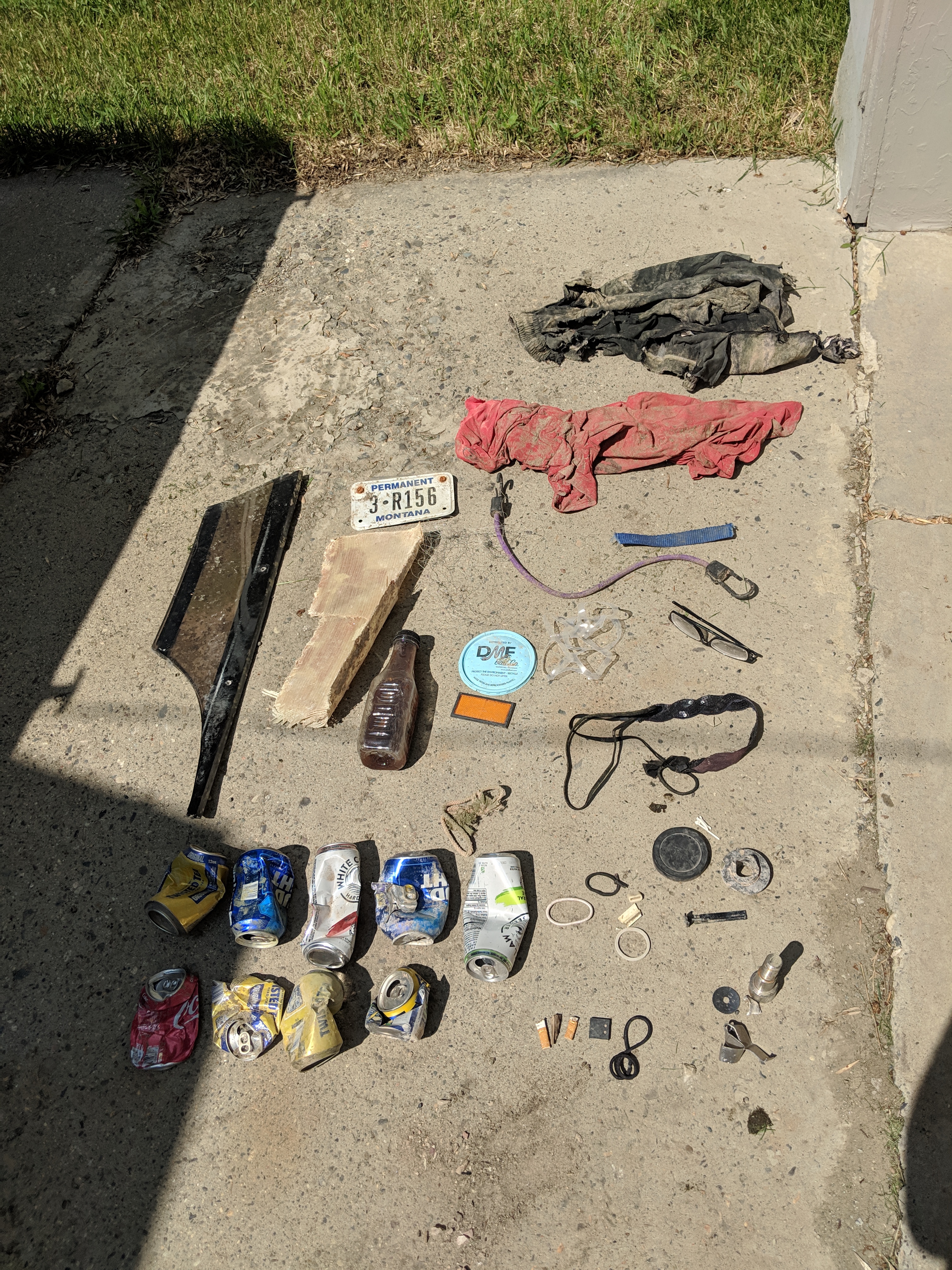
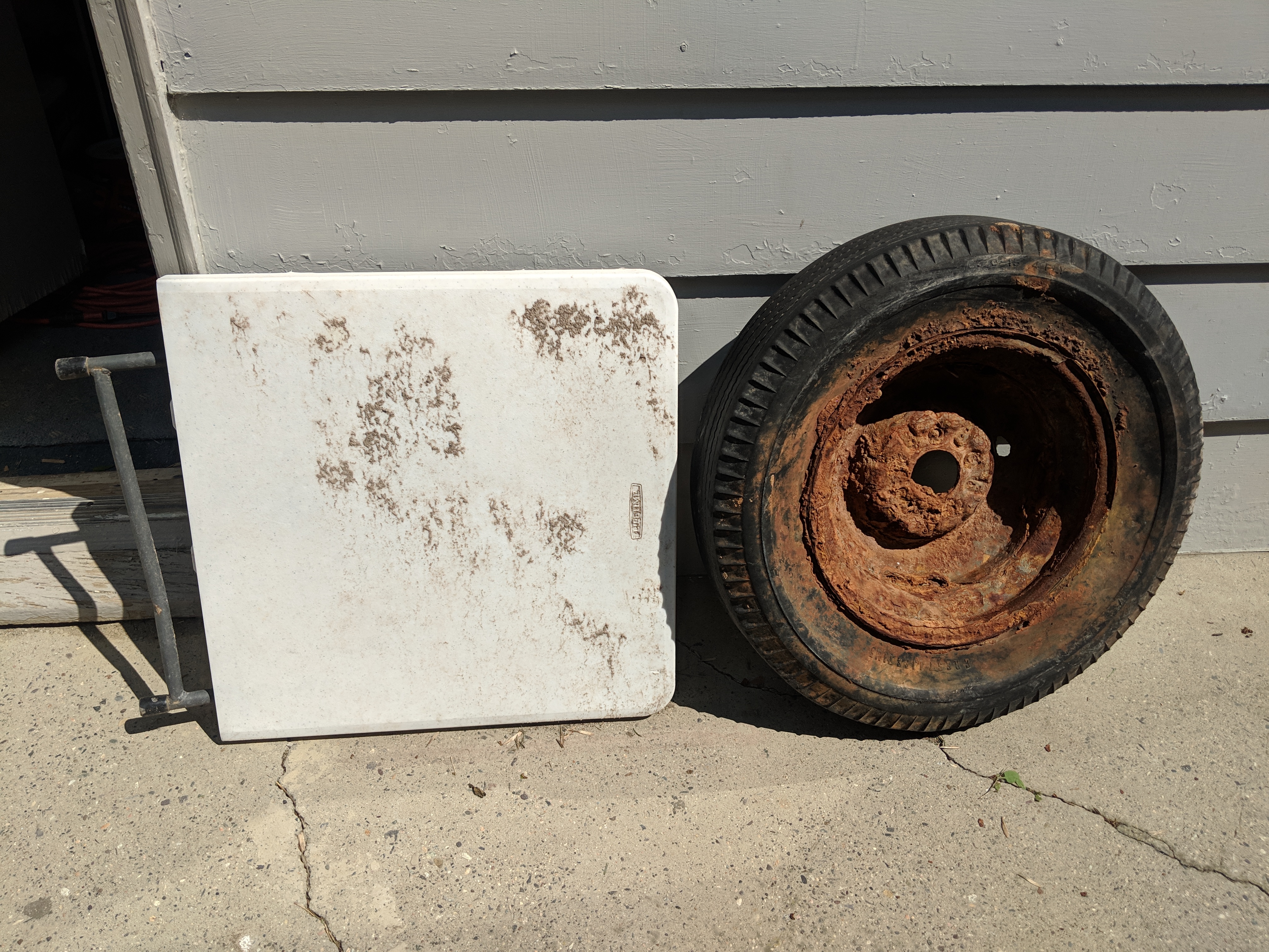
Spare tire and half a fish cleaning table
Cold, partly sunny to rainy conditions
Adventure Scuba
Nic Besel
1
2
2
3
2
2
64.00
46
110.00
3.00
measured
1024.00
1
Al cans
Can package
On
pounds
I have debris data to report
Smooth (wavelets) for waves 0.1 - 0.5 meter high
5
m2
1
feet
other
5
2
9
United States
State\Province
MT
City
Billings
Map Help


Dive Location

If you know your survey site coordinates, enter them manually in decimal degrees using WGS84 Map Datum. Use the minus sign for latitudes south of the equator and longitudes west of the Prime Meridian to 180 degrees.

If you do not know your survey site coordinates, click the “Map Location” tab to use the map to zoom into your survey site and drop the pin on the map to fall within your survey dive site in the water (not on land or the beach). Ensure you zoom in as much as possible to ensure data accuracy.

Entangled Help


Use the vertical tabs below to record any entangled animals you found of each type.

Ecosystem Other
Man-made reservoir

ADS531 - Billy's Grotto

0
0
0
0

17.089162752109, -61.931308186361

0
0
0
coral
0
0
0
0
0
Sandals Grande Antigua (store number 7109)
Maurice Watson
0
0
0
2
0
0
0
0
0
0
0
0
0
0
0
0
0
0
0
4
0
0
0
0
0
0
3
0
0
0
0
0
0
0
0
0
4.00
42
55.00
40.00
0
estimated
0
0
0
0
200.00
0
0
0
0
0
Glass bottles
Plastic
0
On
pounds
0
I have debris data to report
3
0
0
Slight for waves 0.5 -1.25 meter high
0
0
0
0
0
0
0
ft2
0
0
feet
coral reef
0
0
0
0
0
0
0
0
0
0
0
0
0
0
0
0
0
0
0
0
0
0
0
0
0
0
0
0
0
Antigua and Barbuda
City
St Johns
Map Help


Dive Location

If you know your survey site coordinates, enter them manually in decimal degrees using WGS84 Map Datum. Use the minus sign for latitudes south of the equator and longitudes west of the Prime Meridian to 180 degrees.

If you do not know your survey site coordinates, click the “Map Location” tab to use the map to zoom into your survey site and drop the pin on the map to fall within your survey dive site in the water (not on land or the beach). Ensure you zoom in as much as possible to ensure data accuracy.

Entangled Help


Use the vertical tabs below to record any entangled animals you found of each type.

ADS175 - Blue Bay

0
0
0

35.031984, 34.042372

0
0
0
sand
0
0
0
0
0
0
0
0
0
0
0
0
0
0
0
0
0
0
0
0
0
0
0
0
0
Taba Diving Centre
Manuel Vollmer
0
0
0
0
0
0
0
0
0
0
0
0
0
0
0
0
0
0
0
3
0
0
0
0
0
0
0
0
0
0
0
0
0
0
1.00
45
6.00
1.00
0
estimated
0
0
200.00
0
0
0
0
0
1
On
kilograms
0
I have debris data to report
1
0
0
Calm (glassy to rippled) for waves 0 – 0.1 meter high
0
0
2
0
0
0
0
m2
0
0
meters
rocky reef
0
0
0
0
0
0
0
0
0
0
0
0
0
0
0
0
0
0
0
0
0
0
0
0
0
0
0
0
Cyprus
City
Protaras
Map Help


Dive Location

If you know your survey site coordinates, enter them manually in decimal degrees using WGS84 Map Datum. Use the minus sign for latitudes south of the equator and longitudes west of the Prime Meridian to 180 degrees.

If you do not know your survey site coordinates, click the “Map Location” tab to use the map to zoom into your survey site and drop the pin on the map to fall within your survey dive site in the water (not on land or the beach). Ensure you zoom in as much as possible to ensure data accuracy.

Entangled Help


Use the vertical tabs below to record any entangled animals you found of each type.

Subscribe to