Menu

ADS187 - Koh Koun South

2

10.626453, 103.2987

sand
1
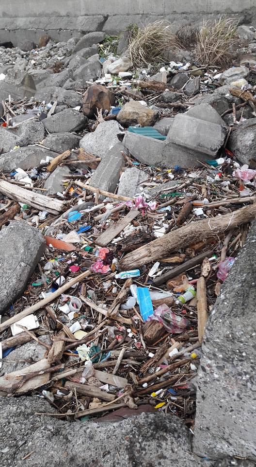
neglect for environment
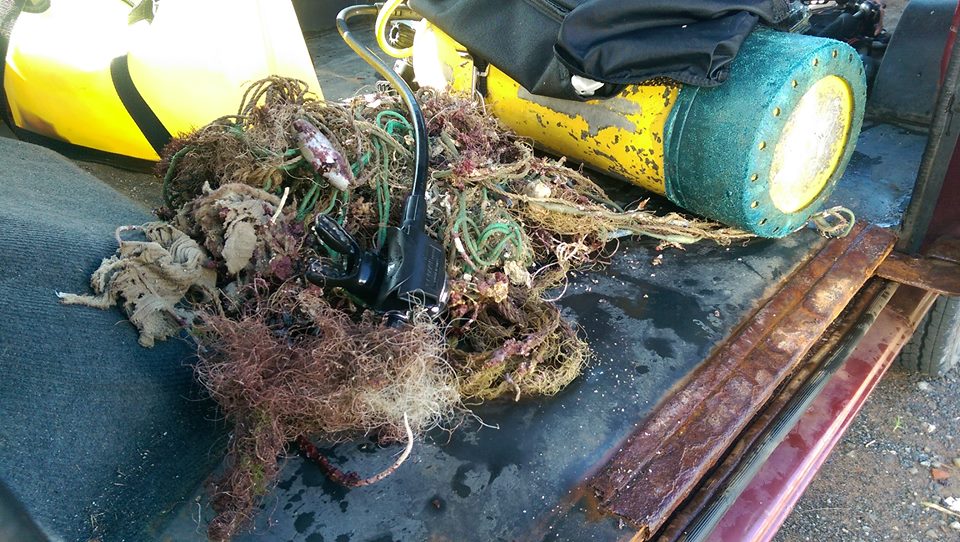
cut out with scissors on boat & then relaeased unharmed
Very severe current under water and cloudy windy day
Had to abort the dive after 14 minutes as current was not allowing us to stay in one place to collect debris, however collected debris at boat level when we returned to surface - as it went by with the current.
Save Cambodian Marine Life
Dianne Martyn
2
2
1
9.95
34
7.50
1.00
1
estimated
6.00
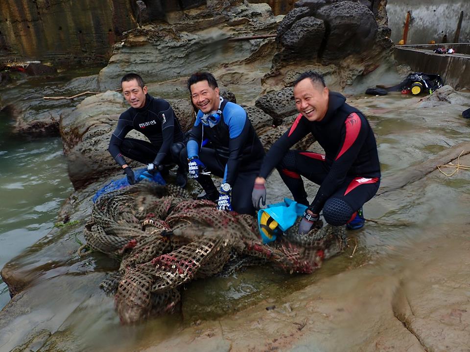
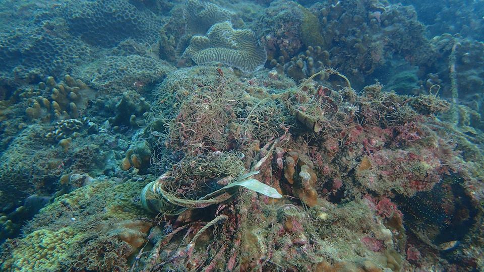
nets covering the coral on the reef
On
kilograms
I have debris data to report
1
Slight for waves 0.5 -1.25 meter high
fine mesh fishing net
Small crabs
Released Unharmed
2
m2
1
meters
coral reef
1
2
1
Cambodia
State\Province
Koh Rong Samloem
City
M'Pai Bay
Map Help


Dive Location

If you know your survey site coordinates, enter them manually in decimal degrees using WGS84 Map Datum. Use the minus sign for latitudes south of the equator and longitudes west of the Prime Meridian to 180 degrees.

If you do not know your survey site coordinates, click the “Map Location” tab to use the map to zoom into your survey site and drop the pin on the map to fall within your survey dive site in the water (not on land or the beach). Ensure you zoom in as much as possible to ensure data accuracy.

Entangled Help


Use the vertical tabs below to record any entangled animals you found of each type.

ADS188 - Sunset Pier

2

10.624192, 103.294936

rock
1
1
fishermen throwing out over side of boats, nets & fishing gear from fishing boats
cut out with scissor & released unharmed
Windy overcast
Save Cambodian Marine Life
Dianne martyn
2
2
1
6.81
45
2.50
1.00
estimated
5.00
On
kilograms
I have debris data to report
Smooth (wavelets) for waves 0.1 - 0.5 meter high
fine net
Micro crab
Released Unharmed
1
1
m2
1
meters
rocky reef
1
1
Cambodia
State\Province
Koh Rong Samloem
City
M'Pai Bay
Map Help


Dive Location

If you know your survey site coordinates, enter them manually in decimal degrees using WGS84 Map Datum. Use the minus sign for latitudes south of the equator and longitudes west of the Prime Meridian to 180 degrees.

If you do not know your survey site coordinates, click the “Map Location” tab to use the map to zoom into your survey site and drop the pin on the map to fall within your survey dive site in the water (not on land or the beach). Ensure you zoom in as much as possible to ensure data accuracy.

Entangled Help


Use the vertical tabs below to record any entangled animals you found of each type.

ADS104 - Loutraki Harbor

37.978736, 22.975437

seagrass
2
GOOD
Loutraki Divers
Chrysanthos Chormpas
1
2
7
4
8
12
50.00
57
7.00
7.00
estimated
3
100.00
On
kilograms
I have debris data to report
34
Calm (glassy to rippled) for waves 0 – 0.1 meter high
5
m2
meters
seagrass
5
23
6
2
4
3
Greece
State\Province
Loutraki
City
Loutraki
Map Help


Dive Location

If you know your survey site coordinates, enter them manually in decimal degrees using WGS84 Map Datum. Use the minus sign for latitudes south of the equator and longitudes west of the Prime Meridian to 180 degrees.

If you do not know your survey site coordinates, click the “Map Location” tab to use the map to zoom into your survey site and drop the pin on the map to fall within your survey dive site in the water (not on land or the beach). Ensure you zoom in as much as possible to ensure data accuracy.

Entangled Help


Use the vertical tabs below to record any entangled animals you found of each type.

Dog's Point

10
14
1
sand
3
2

-8.710478653836269, 115.26984080672264

Less rubbish than we expected in the area.
welcome matt
Generally good however 1 rain storm
Blue Season Bali
Sue Gibbins
1
1
5
1
1
6
2.00
40
8.90
1.50
1
estimated
750.00
plastic bags
food packaging
fishing lines
On
kilograms
I have debris data to report
1
Smooth (wavelets) for waves 0.1 - 0.5 meter high m2
meters
coral reef
Indonesia
State\Province
Bali
City
Sanur
Map Help


Dive Location

If you know your survey site coordinates, enter them manually in decimal degrees using WGS84 Map Datum. Use the minus sign for latitudes south of the equator and longitudes west of the Prime Meridian to 180 degrees.

If you do not know your survey site coordinates, click the “Map Location” tab to use the map to zoom into your survey site and drop the pin on the map to fall within your survey dive site in the water (not on land or the beach). Ensure you zoom in as much as possible to ensure data accuracy.

Entangled Help


Use the vertical tabs below to record any entangled animals you found of each type.

八斗子秘密花園

2

25.14606157613749, 121.79743766784668

silt

25.14606157613749, 121.79743766784668

Po Hsiung Huang
4
31.00
42
25.00
4.00
estimated
1.00
On
kilograms
I have debris data to report
Calm (glassy to rippled) for waves 0 – 0.1 meter high m2
meters
coral reef
Taiwan
Map Help


Dive Location

If you know your survey site coordinates, enter them manually in decimal degrees using WGS84 Map Datum. Use the minus sign for latitudes south of the equator and longitudes west of the Prime Meridian to 180 degrees.

If you do not know your survey site coordinates, click the “Map Location” tab to use the map to zoom into your survey site and drop the pin on the map to fall within your survey dive site in the water (not on land or the beach). Ensure you zoom in as much as possible to ensure data accuracy.

Entangled Help


Use the vertical tabs below to record any entangled animals you found of each type.

墾丁出水口

1

21.94045187565272, 120.79796059057117

sand

21.94045187565272, 120.79796059057117

Po Hsiung Huang
3
9.00
51
7.00
0.00
estimated
2
1.00
On
kilograms
I have debris data to report
Calm (glassy to rippled) for waves 0 – 0.1 meter high m2
meters
coral reef
Taiwan
City
new taipei city
Map Help


Dive Location

If you know your survey site coordinates, enter them manually in decimal degrees using WGS84 Map Datum. Use the minus sign for latitudes south of the equator and longitudes west of the Prime Meridian to 180 degrees.

If you do not know your survey site coordinates, click the “Map Location” tab to use the map to zoom into your survey site and drop the pin on the map to fall within your survey dive site in the water (not on land or the beach). Ensure you zoom in as much as possible to ensure data accuracy.

Entangled Help


Use the vertical tabs below to record any entangled animals you found of each type.

八斗子潮境公園

4
rock
10

25.14207407211195, 121.79517066491826

Po Hsiung Huang
2
20.00
35
20.00
2.00
estimated
2.00
On
kilograms
I have debris data to report
Smooth (wavelets) for waves 0.1 - 0.5 meter high m2
meters
coral reef
Taiwan
City
new taipei city
Map Help


Dive Location

If you know your survey site coordinates, enter them manually in decimal degrees using WGS84 Map Datum. Use the minus sign for latitudes south of the equator and longitudes west of the Prime Meridian to 180 degrees.

If you do not know your survey site coordinates, click the “Map Location” tab to use the map to zoom into your survey site and drop the pin on the map to fall within your survey dive site in the water (not on land or the beach). Ensure you zoom in as much as possible to ensure data accuracy.

Entangled Help


Use the vertical tabs below to record any entangled animals you found of each type.

瑞芳蕃仔澳

66
16
13
6

25.131748532760902, 121.8204429326579

0
0
3
sand
0
34
19
0
0

25.131748532760902, 121.8204429326579

good
Po Hsiung Huang
0
5
0
0
0
0
0
3
31
47
0
3
6
3
0
0
9
9
13
47
69
0
3
8
24
0
0
0
87.00
129
9.00
0.00
7
estimated
63
0
2.00
On
kilograms
I have debris data to report
Calm (glassy to rippled) for waves 0 – 0.1 meter high
0
m2
meters
coral reef
Taiwan
City
new taipei city
Map Help


Dive Location

If you know your survey site coordinates, enter them manually in decimal degrees using WGS84 Map Datum. Use the minus sign for latitudes south of the equator and longitudes west of the Prime Meridian to 180 degrees.

If you do not know your survey site coordinates, click the “Map Location” tab to use the map to zoom into your survey site and drop the pin on the map to fall within your survey dive site in the water (not on land or the beach). Ensure you zoom in as much as possible to ensure data accuracy.

Entangled Help


Use the vertical tabs below to record any entangled animals you found of each type.

Dogs Point

2
6
1
4
sand
13
8

-8.709145061154505, 115.26939120143652

Blue Season Bali
Yoshihiro Ono
2
3
8
1
4
10.00
45
8.30
2.00
estimated
1
2500.00
1
On
kilograms
I have debris data to report
Smooth (wavelets) for waves 0.1 - 0.5 meter high m2
meters
rocky reef
1
1
Indonesia
State\Province
Bali
City
Sanur
Map Help


Dive Location

If you know your survey site coordinates, enter them manually in decimal degrees using WGS84 Map Datum. Use the minus sign for latitudes south of the equator and longitudes west of the Prime Meridian to 180 degrees.

If you do not know your survey site coordinates, click the “Map Location” tab to use the map to zoom into your survey site and drop the pin on the map to fall within your survey dive site in the water (not on land or the beach). Ensure you zoom in as much as possible to ensure data accuracy.

Entangled Help


Use the vertical tabs below to record any entangled animals you found of each type.

Cripple Cove

sand

36.56113505346482, -121.93760186433792

We have been diving here for the past 6 months, since may and we have collected over 5,000 golf balls. This is over 500 pounds of plastic debris which is very toxic to the marine environment because it contains Zinc Acrylate. To find more information check out the link in our bio.
The cove we are diving under is just under the pebble beach golf course
No major surf
1350
Golf Balls
The Plastic Pick-Up
Alex Weber
3
135.00
60
20.00
1.00
measured
2500.00
golf balls
rubber tire pieces
plastic PVC pipe pieces
On
pounds
I have debris data to report
Smooth (wavelets) for waves 0.1 - 0.5 meter high ft2
feet
other
United States
State\Province
CA
City
Carmel
Map Help


Dive Location

If you know your survey site coordinates, enter them manually in decimal degrees using WGS84 Map Datum. Use the minus sign for latitudes south of the equator and longitudes west of the Prime Meridian to 180 degrees.

If you do not know your survey site coordinates, click the “Map Location” tab to use the map to zoom into your survey site and drop the pin on the map to fall within your survey dive site in the water (not on land or the beach). Ensure you zoom in as much as possible to ensure data accuracy.

Entangled Help


Use the vertical tabs below to record any entangled animals you found of each type.

Ecosystem Other
shallow sandy water ranging to shallow reef
Subscribe to