Menu

ADS345 - Divewise House Reef

4
42
1

35.924292, 14.493816

rock
3
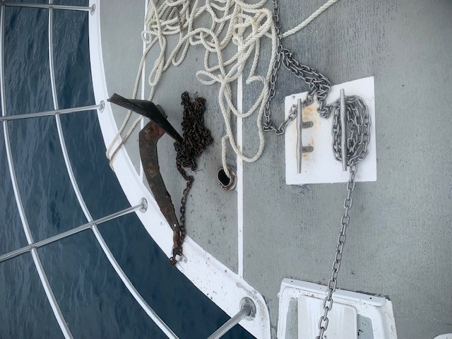
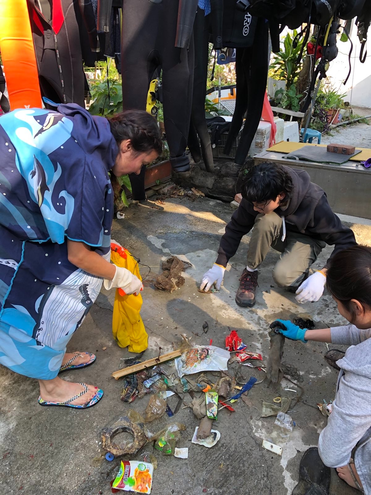
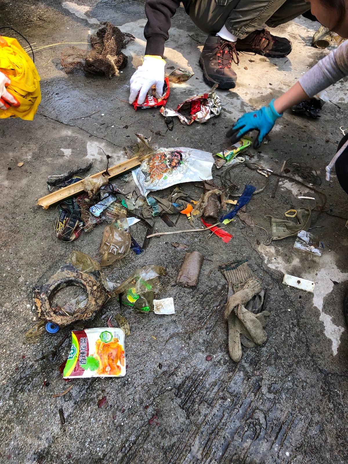
Severe storm over the past week has uncovered historical debris
Firework with parachute
Stormy, rain, wind up to force 7 from east
32
Fibre Glass
Divewise
Howard
6
2
7
1
8
3
1
24.00
70
21.00
2.00
4
estimated
7861.00
17
Glass fragments
Fibre glass
On
kilograms
I have debris data to report
5
3
Slight for waves 0.5 -1.25 meter high
12
3
m2
meters
rocky reef
15
31
10
1
3
7
153
Malta
City
St Julians
Map Help


Dive Location

If you know your survey site coordinates, enter them manually in decimal degrees using WGS84 Map Datum. Use the minus sign for latitudes south of the equator and longitudes west of the Prime Meridian to 180 degrees.

If you do not know your survey site coordinates, click the “Map Location” tab to use the map to zoom into your survey site and drop the pin on the map to fall within your survey dive site in the water (not on land or the beach). Ensure you zoom in as much as possible to ensure data accuracy.

Entangled Help


Use the vertical tabs below to record any entangled animals you found of each type.

Something Special (Bonaire)

1
sand
8

12.161429502167, -68.283816576004

Metal sign saying 'private property no tresspassing'
Calm
1
'Private property' sign (metal)
Claudia Hacke
1
1
1.00
30
4.00
1.50
estimated
60.00
Fishing lines
1
On
kilograms
I have debris data to report
Calm (glassy to rippled) for waves 0 – 0.1 meter high
1
m2
3
meters
coral reef
1
Netherlands Antilles
City
Kralendijk
Map Help


Dive Location

If you know your survey site coordinates, enter them manually in decimal degrees using WGS84 Map Datum. Use the minus sign for latitudes south of the equator and longitudes west of the Prime Meridian to 180 degrees.

If you do not know your survey site coordinates, click the “Map Location” tab to use the map to zoom into your survey site and drop the pin on the map to fall within your survey dive site in the water (not on land or the beach). Ensure you zoom in as much as possible to ensure data accuracy.

Entangled Help


Use the vertical tabs below to record any entangled animals you found of each type.

Captain Foolish

24.839733, -80.626867

coral
Ongoing commercial and recreational fishing
calm
1
anchor and chain
Key Dives
Cortney Benson
2
66.00
45
50.00
30.00
measured
1
5000.00
anchor
fishing debris
On
pounds
I have debris data to report
Smooth (wavelets) for waves 0.1 - 0.5 meter high ft2
1
feet
coral reef
United States
State\Province
FL
City
Islamorada
Map Help


Dive Location

If you know your survey site coordinates, enter them manually in decimal degrees using WGS84 Map Datum. Use the minus sign for latitudes south of the equator and longitudes west of the Prime Meridian to 180 degrees.

If you do not know your survey site coordinates, click the “Map Location” tab to use the map to zoom into your survey site and drop the pin on the map to fall within your survey dive site in the water (not on land or the beach). Ensure you zoom in as much as possible to ensure data accuracy.

Entangled Help


Use the vertical tabs below to record any entangled animals you found of each type.

ADS474 - Yellow Submarine

9

12.158809323006, -68.280972871826

1
sand
10

12.158809323006, -68.280972871826

Saw one green turtle with big fish hook in his mouth.
Inner tire of bicycle
Calm
Dive Freinds
Duncan Versteegh
2
2
1
2
7
3.00
75
10.00
2.00
estimated
3500.00
2
1
fishing line
plastic
2
On
kilograms
I have debris data to report
Calm (glassy to rippled) for waves 0 – 0.1 meter high m2
1
meters
coral reef
1
1
1
2
Netherlands Antilles
City
Kralendijk
Map Help


Dive Location

If you know your survey site coordinates, enter them manually in decimal degrees using WGS84 Map Datum. Use the minus sign for latitudes south of the equator and longitudes west of the Prime Meridian to 180 degrees.

If you do not know your survey site coordinates, click the “Map Location” tab to use the map to zoom into your survey site and drop the pin on the map to fall within your survey dive site in the water (not on land or the beach). Ensure you zoom in as much as possible to ensure data accuracy.

Entangled Help


Use the vertical tabs below to record any entangled animals you found of each type.

CFK Lagoon

9
silt
1

24.584176999746, -81.745114038192

I found a piece of tarp that was destroyed by hurricane Irma in 2016. We are still finding pieces of that tarp in our lagoon 5 years later.
Calm
The College of the Florida Keys
Lucja Rice
1
1
2
1
0.82
90
25.00
15.00
measured
2000.00
On
pounds
I have debris data to report
Calm (glassy to rippled) for waves 0 – 0.1 meter high m2
feet
mangroves
United States
State\Province
Florida
City
Key West
Map Help


Dive Location

If you know your survey site coordinates, enter them manually in decimal degrees using WGS84 Map Datum. Use the minus sign for latitudes south of the equator and longitudes west of the Prime Meridian to 180 degrees.

If you do not know your survey site coordinates, click the “Map Location” tab to use the map to zoom into your survey site and drop the pin on the map to fall within your survey dive site in the water (not on land or the beach). Ensure you zoom in as much as possible to ensure data accuracy.

Entangled Help


Use the vertical tabs below to record any entangled animals you found of each type.

ADS323 - Tung Ping Chau

30
68

22.545909, 114.431823

4
1
sand
3
50
6
2
Diaper, rope (diameter 20cm), surgical masks
Sunny
Tursiopsdivers
Eszter
8
3
4
5
8
1
2
10
3
9
1
2
20.50
48
5.90
1.00
16
measured
2988.31
Plastic wrappers
2
On
kilograms
I have debris data to report
Calm (glassy to rippled) for waves 0 – 0.1 meter high
2
1
Rope, plastic wrap
Rock crab, shrimp
Released Unharmed
3
2
3
m2
meters
coral reef
1
4
1
6
1
2
4
Hong Kong S.A.R., China
Map Help


Dive Location

If you know your survey site coordinates, enter them manually in decimal degrees using WGS84 Map Datum. Use the minus sign for latitudes south of the equator and longitudes west of the Prime Meridian to 180 degrees.

If you do not know your survey site coordinates, click the “Map Location” tab to use the map to zoom into your survey site and drop the pin on the map to fall within your survey dive site in the water (not on land or the beach). Ensure you zoom in as much as possible to ensure data accuracy.

Entangled Help


Use the vertical tabs below to record any entangled animals you found of each type.

Alimos underwater cleanup with Garnier

4
3
sand
5
15
5
3

37.909054060541, 23.71178370098

https://allforblue.org/2021/11/08/beach-and-underwater-cleanup-at-the-beach-of-alimos-with-garnier/
calm
All For Blue
Katerina Topouzoglou
5
4
8
15
3
5
6
6
22
19
18
4
4
3
1
3
254.00
56
8.00
1.00
measured
7
6777.00
2
2
On
kilograms
I have debris data to report
27
Calm (glassy to rippled) for waves 0 – 0.1 meter high
8
4
m2
3
meters
rocky reef
2
3
4
13
1
3
87
4
1
1
4
7
3
Greece
City
Athens
Map Help


Dive Location

If you know your survey site coordinates, enter them manually in decimal degrees using WGS84 Map Datum. Use the minus sign for latitudes south of the equator and longitudes west of the Prime Meridian to 180 degrees.

If you do not know your survey site coordinates, click the “Map Location” tab to use the map to zoom into your survey site and drop the pin on the map to fall within your survey dive site in the water (not on land or the beach). Ensure you zoom in as much as possible to ensure data accuracy.

Entangled Help


Use the vertical tabs below to record any entangled animals you found of each type.

Ladders

24.889236, -80.554383

coral
60
Ongoing commercial and recreational fishing
Tickle stick
Windy
2
1
Anchor
Tickle Stick
Key Dives
Cortney
18
241.00
45
45.00
30.00
measured
1
2
6
50000.00
Lobster Traps
Anchors
Fishing Line
On
pounds
I have debris data to report
1
Slight for waves 0.5 -1.25 meter high
8
ft2
30
feet
coral reef
1
United States
State\Province
FL
City
Islamorada
Map Help


Dive Location

If you know your survey site coordinates, enter them manually in decimal degrees using WGS84 Map Datum. Use the minus sign for latitudes south of the equator and longitudes west of the Prime Meridian to 180 degrees.

If you do not know your survey site coordinates, click the “Map Location” tab to use the map to zoom into your survey site and drop the pin on the map to fall within your survey dive site in the water (not on land or the beach). Ensure you zoom in as much as possible to ensure data accuracy.

Entangled Help


Use the vertical tabs below to record any entangled animals you found of each type.

Chutes

24.900567, -80.531083

coral
20
Hoop Net
Windy
2
1
Anchors
Hoop Net
Key Dives
Cortney
18
366.00
50
60.00
30.00
measured
1
3
5
50000.00
Lobster Traps
Anchors
Fishing Line
On
pounds
I have debris data to report
1
Slight for waves 0.5 -1.25 meter high
20
ft2
30
feet
coral reef
1
United States
State\Province
FL
City
Islamorada
Map Help


Dive Location

If you know your survey site coordinates, enter them manually in decimal degrees using WGS84 Map Datum. Use the minus sign for latitudes south of the equator and longitudes west of the Prime Meridian to 180 degrees.

If you do not know your survey site coordinates, click the “Map Location” tab to use the map to zoom into your survey site and drop the pin on the map to fall within your survey dive site in the water (not on land or the beach). Ensure you zoom in as much as possible to ensure data accuracy.

Entangled Help


Use the vertical tabs below to record any entangled animals you found of each type.

Dougie's Dip

24.900883, -80.529733

coral
25
ongoing commercial and recreational fishing
Both were trapped inside a derelict lobster trap.
Windy
1
3
Plastic Lobster Trap Entrance
Anchor with chain
Key Dives
Cortney
18
250.00
45
50.00
30.00
measured
2
4
30000.00
Lobster Traps
Anchors
Fishing line
On
pounds
I have debris data to report
Slight for waves 0.5 -1.25 meter high
26
Released Unharmed
Porcupinefish & Trunk Fish
2
Lobster Trap
ft2
30
feet
coral reef
1
United States
State\Province
FL
City
Islamorada
Map Help


Dive Location

If you know your survey site coordinates, enter them manually in decimal degrees using WGS84 Map Datum. Use the minus sign for latitudes south of the equator and longitudes west of the Prime Meridian to 180 degrees.

If you do not know your survey site coordinates, click the “Map Location” tab to use the map to zoom into your survey site and drop the pin on the map to fall within your survey dive site in the water (not on land or the beach). Ensure you zoom in as much as possible to ensure data accuracy.

Entangled Help


Use the vertical tabs below to record any entangled animals you found of each type.

Subscribe to